Lenhart Farmhouse

Log in to your account

AroundUs is a community-driven map of interesting places, built by curious explorers like you. It grows with every review, story, and photo you share.
Connect to save your favorite spots, contribute locations, and create personalized routes.
Continue with Google
Continue with Apple
Continue with X
Continue with Facebook
Continue with email
By continuing, you accept our Terms and Conditions and our Privacy Policy
Create an account
Add to collection
Map
Suggest a change
Share

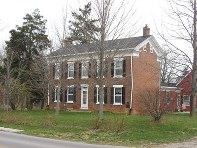
Lenhart Farmhouse, Historic farmhouse in Root Township, United States.

Lenhart Farmhouse is a two-story masonry house in Root Township with a gable roof and thick brick walls constructed in common bond pattern. Inside, a central walnut staircase rises through three stories, and later additions include an enclosed porch conversion to kitchen space and a bedroom extension.

The land was patented to Benjamin Franklin Blossom in 1836 before John Lehnart purchased the farmhouse site in 1845. The house's architectural style reflects building practices of that era.

The property sits along a road with historical significance and overlooks the river bottomland of the St. Marys River, which Native Americans called Nameewa Siipiiwi. This location ties the farmhouse story to the land's deeper past and its original inhabitants.

The property encompasses roughly 1.7 acres with brick foundation and cellar areas beneath the main structure. Visitors should note that the various additions come from different periods, which helps when exploring the building's layout.

An adjacent creek, once called Lenhart's Run, flows as a natural tributary into the St. Marys River, traditionally known as the Sturgeon River. This local waterway played a role in why settlers chose this land.

Location: Root Township

Architectural style: Federal architecture, Greek Revival architecture

GPS coordinates: 40.84640,-84.92000

Latest update: December 14, 2025 14:21

Photos
Around this place
Nickel Plate Road 765
United States of America

Nickel Plate Road 765

26.9 km
Ouabache State Park
United States of America

Ouabache State Park

21.3 km
Richardville House
United States of America

Richardville House

29.1 km
Gene Stratton Porter Cabin
United States of America

Gene Stratton Porter Cabin

29.1 km
United States of America

Fort Wayne Moraine

18.4 km
Brumback Library
United States of America

Brumback Library

28.4 km
Marsh Foundation School
United States of America

Marsh Foundation School

30.1 km
Van Wert County Courthouse
United States of America

Van Wert County Courthouse

28.6 km
Fort Wayne Park and Boulevard System Historic District
United States of America

Fort Wayne Park and Boulevard System Historic District

28.2 km
St. Louis, Besancon, Historic District
United States of America

St. Louis, Besancon, Historic District

22.8 km
Ceylon Covered Bridge
United States of America

Ceylon Covered Bridge

25.9 km
Peace Monument
United States of America

Peace Monument

1.9 km
Van Wert Bandstand
United States of America

Van Wert Bandstand

28.6 km
St. Peter's Square
United States of America

St. Peter's Square

30.1 km
Adams County Courthouse
United States of America

Adams County Courthouse

1.9 km
Southwood Park Historic District
United States of America

Southwood Park Historic District

29.1 km
Stewart-Studebaker House
United States of America

Stewart-Studebaker House

24.6 km
Charles Dugan House
United States of America

Charles Dugan House

1.8 km
Wells County Courthouse
United States of America

Wells County Courthouse

24.3 km
Lafayette Place Historic District
United States of America

Lafayette Place Historic District

28.4 km
Bethel Methodist Episcopal Church
United States of America

Bethel Methodist Episcopal Church

24.5 km
Geneva Downtown Commercial Historic District
United States of America

Geneva Downtown Commercial Historic District

28.5 km
Foster Park Neighborhood Historic District
United States of America

Foster Park Neighborhood Historic District

29.9 km
Round Barn
United States of America

Round Barn

13.3 km
Villa North Historic District
United States of America

Villa North Historic District

23.6 km
Oakdale Historic District
United States of America

Oakdale Historic District

29.8 km
Ben Colter Polygonal Barn
United States of America

Ben Colter Polygonal Barn

8.6 km
John S. Bowers House
United States of America

John S. Bowers House

1.4 km
Show the full map
Reviews

Visited this place? Tap the stars to rate it and share your experience / photos with the community! Try now! You can cancel it anytime.

« Lenhart Farmhouse - Historic farmhouse in Root Township, United States » is provided by Around Us (aroundus.com). Images and texts are derived from Wikimedia project under a Creative Commons license. You are allowed to copy, distribute, and modify copies of this page, under the conditions set by the license, as long as this note is clearly visible.

Discover hidden gems everywhere you go!

From secret cafés to breathtaking viewpoints, skip the crowded tourist spots and find places that match your style. Our app makes it easy with voice search, smart filtering, route optimization, and insider tips from travelers worldwide. Download now for the complete mobile experience.

Around Us App Screenshot

A unique approach to discovering new places

Le Figaro

All the places worth exploring

France Info

A tailor-made excursion in just a few clicks

20 Minutes