Enable Location

We need your location to show you interesting places around you

Discover nearby places

Find interesting locations and hidden gems around you

Precise directions

Get accurate directions and distances to places

Your location is never shared with other users. It's only used when you tap the location button.

Charles-George Reclamation Trust Landfill

Log in to your account

Start exploring — it's free

Trusted by 62,984 travelers worldwide

Continue with Google
Continue with Apple
or

We will send you a code to connect

By continuing, you accept our Terms and Conditions and our Privacy Policy

Check your inbox

We've sent a pincode in your inbox. Please enter the code below.

Charles-George Reclamation Trust Landfill
Discussion Reviews 1 Photos
1.3k Popularity

Charles-George Reclamation Trust Landfill, Superfund landfill site in Tyngsborough, Massachusetts

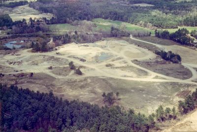
The Charles-George Reclamation Trust Landfill is a former waste facility occupying about 19 acres of land near Flint Pond Marsh and Dunstable Brook. It sits roughly 1 mile south of Tyngsborough's town center and is now marked by engineering controls and ongoing environmental monitoring systems.

The site began as a small municipal dump in the 1950s and expanded to accept industrial and chemical waste materials over time. Operations ceased in 1983, after which the property entered a long phase of remediation and environmental oversight.

The site's name reflects the families who shaped waste management in the region during its operational years. Today you can observe how local residents and agencies work together to monitor environmental conditions at the location.

The site is not open to casual public visits because active management and monitoring remain in effect. For information, contact the EPA or local authorities, which publish regular updates on safety conditions and environmental status.

The formerly contaminated property now hosts a 2.6-megawatt solar farm that has fed electricity into the local grid since 2017. The transformation demonstrates how old industrial sites can become sources of renewable energy production.

The community of curious travelers

AroundUs brings together thousands of curated places, local tips, and hidden gems, enriched daily by 60,000 contributors worldwide.

Start exploring
GPS coordinates
42.66590,-71.44576
Latest update
December 14, 2025 17:41
Around this place
Haystack Observatory
United States of America

Haystack Observatory

5.9 km
Pawtucket Falls
United States of America

Pawtucket Falls

9.5 km
Lowell Heritage State Park
United States of America

Lowell Heritage State Park

7.9 km
Tyngsborough Bridge
United States of America

Tyngsborough Bridge

2.3 km
Millstone Hill Antenna
United States of America

Millstone Hill Antenna

6.5 km
Fun-World
United States of America

Fun-World

5.6 km
Jerathmell Bowers House
United States of America

Jerathmell Bowers House

8.4 km
Graniteville Historic District
United States of America

Graniteville Historic District

8.1 km
Allen House
United States of America

Allen House

9.3 km
Millstone Hill Observatory
United States of America

Millstone Hill Observatory

6.4 km
Brookside Historic District
United States of America

Brookside Historic District

6.8 km
Old Town Hall
United States of America

Old Town Hall

2 km
Killicut-Way House
United States of America

Killicut-Way House

7.6 km
United States of America

Stony Brook

6.6 km
Chelmsford Glass Works' Long House
United States of America

Chelmsford Glass Works' Long House

8.7 km
North Town Hall
United States of America

North Town Hall

6.1 km
Dunstable Town Hall
United States of America

Dunstable Town Hall

3.5 km
Westford Town Farm
United States of America

Westford Town Farm

9.3 km
Fairview Cemetery
United States of America

Fairview Cemetery

9 km
Winslow School and Littlefield Library
United States of America

Winslow School and Littlefield Library

2.2 km
Wright Cemetery
United States of America

Wright Cemetery

6.6 km
Tyler Park Historic District
United States of America

Tyler Park Historic District

9.4 km
Jonathon Keyes Sr. House
United States of America

Jonathon Keyes Sr. House

7.8 km
District 7 School
United States of America

District 7 School

9.2 km
Bennett-Shattuck House
United States of America

Bennett-Shattuck House

8.7 km
Max's Country Golf
United States of America

Max's Country Golf

3.2 km
Dunstable Center Historic District
United States of America

Dunstable Center Historic District

3.1 km
Mascuppic Lake Beach
United States of America

Mascuppic Lake Beach

4.6 km
Show the full map
Reviews
Share your experience

No review yet

Discussions
Start a discussion...

No discussion yet

« Charles-George Reclamation Trust Landfill - Superfund landfill site in Tyngsborough, Massachusetts » is provided by Around Us (aroundus.com). Images and texts are derived from Wikimedia project under a Creative Commons license. You are allowed to copy, distribute, and modify copies of this page, under the conditions set by the license, as long as this note is clearly visible.

Discover hidden gems everywhere you go!

From secret cafés to breathtaking viewpoints, skip the crowded tourist spots and find places that match your style. Our app makes it easy with voice search, smart filtering, route optimization, and insider tips from travelers worldwide. Download now for the complete mobile experience.

Around Us App Screenshot

A unique approach to discovering new places

Le Figaro

All the places worth exploring

France Info

A tailor-made excursion in just a few clicks

20 Minutes

Around Us
Travel Guide & Maps
Download

Send to your phone

QR Code
1

Open the camera app on your mobile.

2

Point at the QR code with your camera. A notification will appear.

3

Tap the notification to open the link.