Enable Location

We need your location to show you interesting places around you

Discover nearby places

Find interesting locations and hidden gems around you

Precise directions

Get accurate directions and distances to places

Your location is never shared with other users. It's only used when you tap the location button.

Charles Spangenberg Farmstead

Log in to your account

Start exploring — it's free

Trusted by 62,941 travelers worldwide

Continue with Google
Continue with Apple
or

We will send you a code to connect

By continuing, you accept our Terms and Conditions and our Privacy Policy

Check your inbox

We've sent a pincode in your inbox. Please enter the code below.

Discussion Reviews 1 Photos
1.4k Popularity

Charles Spangenberg Farmstead, human settlement in Woodbury, Minnesota, United States of America

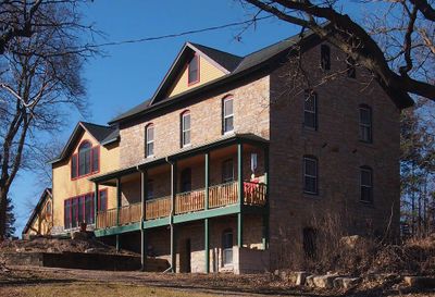
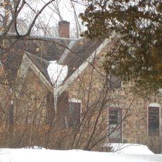
Charles Spangenberg Farmstead is a historic farm in Woodbury with structures built in the late 1800s, including a limestone house from 1871, a large barn built around 1887, and a granary from about 1875. The buildings sit closely together on a small hill and display traditional construction methods using timber framing and locally sourced materials.

Charles Spangenberg was a pioneer who founded this farm with his brother Frederick in the late 1800s using locally quarried limestone for the original house. The farm remained in the family but was sold to the Czikalla family in 1901, who operated a dairy operation and added more structures, before the site was listed on the National Register of Historic Places in 1978.

The name Spangenberg comes from Charles, the pioneer who established this farm in the late 1800s. The buildings reflect how early settlers built with local materials and practical designs that shaped daily life for farming families.

The site is easy to access, located just off Dale Road, with open fields and room to walk around the various buildings on the property. Visitors can move through the structures and surrounding land to imagine how daily work and life unfolded on this farm over a century ago.

The thick limestone walls of the house, measuring roughly 2 feet (0.6 m) at the base and tapering toward the top, show how settlers built efficiently with local materials. The barn was strategically built into a slope to provide access to different levels for animals and hay storage, a practical design still visible today.

The community of curious travelers

AroundUs brings together thousands of curated places, local tips, and hidden gems, enriched daily by 60,000 contributors worldwide.

Start exploring
Location
GPS coordinates
44.87583,-92.91472
Latest update
February 9, 2026 07:47
Around this place
Indian Mounds Park
United States of America

Indian Mounds Park

13.4 km
Afton State Park
United States of America

Afton State Park

10.5 km
El Burrito Mercado
United States of America

El Burrito Mercado

14.2 km
Lock and Dam No. 2
United States of America

Lock and Dam No. 2

13.4 km
Kinnickinnic State Park
United States of America

Kinnickinnic State Park

13.9 km
St. Paul Minnesota Temple
United States of America

St. Paul Minnesota Temple

12.3 km
Rock Island Swing Bridge
United States of America

Rock Island Swing Bridge

7.8 km
Wakota Bridge
United States of America

Wakota Bridge

8 km
Stockyards Exchange
United States of America

Stockyards Exchange

9.5 km
St. Paul Union Pacific Rail Bridge
United States of America

St. Paul Union Pacific Rail Bridge

11.7 km
Cordenio Severance House
United States of America

Cordenio Severance House

3.1 km
St. Stefan's Romanian Orthodox Church
United States of America

St. Stefan's Romanian Orthodox Church

10 km
Serbian Home
United States of America

Serbian Home

9.7 km
Riverside Hangar
United States of America

Riverside Hangar

13.7 km
Reuben Freeman House
United States of America

Reuben Freeman House

10.7 km
Riverview Branch Library
United States of America

Riverview Branch Library

14.7 km
George W. Wentworth House
United States of America

George W. Wentworth House

12.7 km
Saint Matthew's School
United States of America

Saint Matthew's School

14.8 km
John P. Furber House
United States of America

John P. Furber House

4.4 km
Charles W. Schneider House
United States of America

Charles W. Schneider House

13.8 km
Euclid View Flats
United States of America

Euclid View Flats

14.8 km
John T. Cyphers House
United States of America

John T. Cyphers House

14.9 km
Newington Gilbert House
United States of America

Newington Gilbert House

10.4 km
Rau/Strong House
United States of America

Rau/Strong House

14.7 km
Giesen–Hauser House
United States of America

Giesen–Hauser House

14.3 km
Mitchell Jackson Farmhouse
United States of America

Mitchell Jackson Farmhouse

12.9 km
Lake Elmo Regional Park
United States of America

Lake Elmo Regional Park

12.1 km
Sun Ray Branch Library
United States of America

Sun Ray Branch Library

11.6 km
Show the full map
Reviews
Share your experience

No review yet

Discussions
Start a discussion...

No discussion yet

« Charles Spangenberg Farmstead - human settlement in Woodbury, Minnesota, United States of America » is provided by Around Us (aroundus.com). Images and texts are derived from Wikimedia project under a Creative Commons license. You are allowed to copy, distribute, and modify copies of this page, under the conditions set by the license, as long as this note is clearly visible.

Discover hidden gems everywhere you go!

From secret cafés to breathtaking viewpoints, skip the crowded tourist spots and find places that match your style. Our app makes it easy with voice search, smart filtering, route optimization, and insider tips from travelers worldwide. Download now for the complete mobile experience.

Around Us App Screenshot

A unique approach to discovering new places

Le Figaro

All the places worth exploring

France Info

A tailor-made excursion in just a few clicks

20 Minutes

Around Us
Travel Guide & Maps
Download

Send to your phone

QR Code
1

Open the camera app on your mobile.

2

Point at the QR code with your camera. A notification will appear.

3

Tap the notification to open the link.