Enable Location

We need your location to show you interesting places around you

Discover nearby places

Find interesting locations and hidden gems around you

Precise directions

Get accurate directions and distances to places

Your location is never shared with other users. It's only used when you tap the location button.

Newburgh Lock and Dam

Log in to your account

Start exploring — it's free

Trusted by 63,002 travelers worldwide

Continue with Google
Continue with Apple
or

We will send you a code to connect

By continuing, you accept our Terms and Conditions and our Privacy Policy

Check your inbox

We've sent a pincode in your inbox. Please enter the code below.

Newburgh Lock and Dam
Discussion Reviews 1 Photos
2.3k Popularity

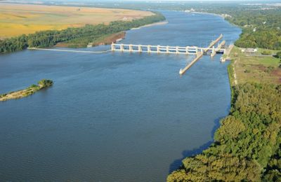
Newburgh Lock and Dam, Lock and gravity dam on Ohio River, Henderson County, United States

Newburgh Lock and Dam is a water control structure spanning the Ohio River with two separate locks that allow vessels to pass through different water levels. The facility uses large gates to regulate flow and maintain a stable water level for navigation year-round.

The project started in the mid-1960s and was completed in the 1970s, replacing older facilities that had previously managed river traffic. Its completion modernized how water and vessel traffic were controlled on this section of the Ohio River.

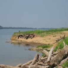
The facility connects communities along the Ohio River through water transportation, supporting local commerce and regional trade. This connection shapes how people in the area interact and depend on the river for their livelihoods.

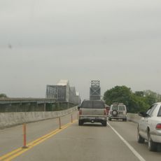
The location is best visited during daylight hours when river activity is visible and the structure can be seen clearly. Public access is available from nearby roads and walking paths, though visitors should stay aware of active shipping traffic.

The facility uses a series of large gates to control water flow, which visitors can watch operating at different water levels throughout the year. These gates are especially interesting to observe when handling the river's seasonal variations.

The community of curious travelers

AroundUs brings together thousands of curated places, local tips, and hidden gems, enriched daily by 60,000 contributors worldwide.

Start exploring
Location
GPS coordinates
37.92940,-87.37340
Latest update
December 13, 2025 12:24
Around this place
Angel Mounds
United States of America

Angel Mounds

7.3 km
Bi-State Vietnam Gold Star Bridges
United States of America

Bi-State Vietnam Gold Star Bridges

15.8 km
Wesselman Woods Nature Preserve
United States of America

Wesselman Woods Nature Preserve

13.2 km
St. Benedict Cathedral
United States of America

St. Benedict Cathedral

15.4 km
United States of America

Haynies Corner Arts District

17.3 km
Yankeetown Site
United States of America

Yankeetown Site

6.7 km
Bayard Park Neighborhood
United States of America

Bayard Park Neighborhood

16 km
Alhambra Theatorium
United States of America

Alhambra Theatorium

17.3 km
Washington Avenue Historic District
United States of America

Washington Avenue Historic District

16.6 km
Bernardin-Johnson House
United States of America

Bernardin-Johnson House

13.9 km
Ellerbusch Site
United States of America

Ellerbusch Site

5.2 km
Liberty Baptist Church
United States of America

Liberty Baptist Church

17.3 km
Old Newburgh Presbyterian Church
United States of America

Old Newburgh Presbyterian Church

3.3 km
Independence Historic District
United States of America

Independence Historic District

16.6 km
Edgar A. Igleheart House
United States of America

Edgar A. Igleheart House

10.7 km
Boonville Public Square Historic District
United States of America

Boonville Public Square Historic District

15.9 km
Old Warrick County Jail
United States of America

Old Warrick County Jail

16.1 km
John W. Boehne House
United States of America

John W. Boehne House

15.7 km
Roberts-Morton House
United States of America

Roberts-Morton House

1.9 km
Original Newburgh Historic District
United States of America

Original Newburgh Historic District

3.3 km
Peter Augustus Maier House
United States of America

Peter Augustus Maier House

17.2 km
Hooker-Ensle-Pierce House
United States of America

Hooker-Ensle-Pierce House

16.8 km
William Bedford Sr. House
United States of America

William Bedford Sr. House

16 km
Michael Schaeffer House
United States of America

Michael Schaeffer House

17.1 km
Parson and Scoville Building
United States of America

Parson and Scoville Building

17.5 km
John James Audubon State Park
United States of America

John James Audubon State Park

16.2 km
Lincolnshire Historic District
United States of America

Lincolnshire Historic District

17 km
Riverside Historic District
United States of America

Riverside Historic District

16.6 km
Show the full map
Reviews
Share your experience

No review yet

Discussions
Start a discussion...

No discussion yet

« Newburgh Lock and Dam - Lock and gravity dam on Ohio River, Henderson County, United States » is provided by Around Us (aroundus.com). Images and texts are derived from Wikimedia project under a Creative Commons license. You are allowed to copy, distribute, and modify copies of this page, under the conditions set by the license, as long as this note is clearly visible.

Discover hidden gems everywhere you go!

From secret cafés to breathtaking viewpoints, skip the crowded tourist spots and find places that match your style. Our app makes it easy with voice search, smart filtering, route optimization, and insider tips from travelers worldwide. Download now for the complete mobile experience.

Around Us App Screenshot

A unique approach to discovering new places

Le Figaro

All the places worth exploring

France Info

A tailor-made excursion in just a few clicks

20 Minutes

Around Us
Travel Guide & Maps
Download

Send to your phone

QR Code
1

Open the camera app on your mobile.

2

Point at the QR code with your camera. A notification will appear.

3

Tap the notification to open the link.