Enable Location

We need your location to show you interesting places around you

Discover nearby places

Find interesting locations and hidden gems around you

Precise directions

Get accurate directions and distances to places

Your location is never shared with other users. It's only used when you tap the location button.

Grave Creek Bridge

Log in to your account

Start exploring — it's free

Trusted by 62,437 travelers worldwide

Continue with Google
Continue with Apple
or

We will send you a code to connect

By continuing, you accept our Terms and Conditions and our Privacy Policy

Check your inbox

We've sent a pincode in your inbox. Please enter the code below.

Grave Creek Bridge, Covered bridge in Sunny Valley, Oregon.

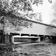
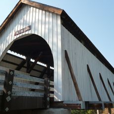
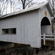
Grave Creek Bridge is a covered wooden bridge roughly 105 feet long with distinctive Gothic windows on both sides and rounded portals. The structure features a shake roof and crosses the creek below while carrying a local road over the water.

The bridge was built in 1920 and originally served as a crossing for the Pacific Highway, a major north-south route of its time. It received recognition on the National Register in 1979 and underwent significant restoration work from the late 1990s into the 2000s.

The bridge represents a connection between rural communities in the region and reflects how transportation shaped settlement patterns. Visitors can see how the structure was designed to serve local traffic rather than major highways.

The bridge sits about 15 miles north of Grants Pass and is visible from Interstate 5, making it accessible for those passing through the area. You can approach it on foot to examine the wooden structure and interior details up close.

The bridge was designed using a Howe truss system by engineers A.A. Clausen and J. Elmer Nelson, a structural approach that proved durable enough to serve for over a century. This particular construction method became one of the most reliable timber bridge designs of its era.

The community of curious travelers

AroundUs brings together thousands of curated places, local tips, and hidden gems, enriched daily by 60,000 contributors worldwide.

Start exploring
Location
GPS coordinates
42.63583,-123.37750
Latest update
December 14, 2025 17:02
Around this place
Oregon Vortex
United States of America

Oregon Vortex

28.8 km
Golden
United States of America

Golden

6.5 km
Wolf Creek Inn
United States of America

Wolf Creek Inn

6.8 km
Valley of the Rogue State Park
United States of America

Valley of the Rogue State Park

31.2 km
Medford Oregon Temple
United States of America

Medford Oregon Temple

46.7 km
Rogue River Ranch
United States of America

Rogue River Ranch

42.3 km
Zane Grey Cabin
United States of America

Zane Grey Cabin

35.7 km
TouVelle State Recreation Site
United States of America

TouVelle State Recreation Site

45.4 km
Jackson County Fairground
United States of America

Jackson County Fairground

47.3 km
Rand Ranger Station
United States of America

Rand Ranger Station

17.5 km
Whisky Creek Cabin
United States of America

Whisky Creek Cabin

21.2 km
Chavner Family House
United States of America

Chavner Family House

36.3 km
Redwoods Hotel
United States of America

Redwoods Hotel

22.1 km
Milo Academy Bridge
United States of America

Milo Academy Bridge

43.4 km
Fort Lane
United States of America

Fort Lane

40.3 km
Horse Creek Bridge
United States of America

Horse Creek Bridge

43.7 km
Wimer Bridge
United States of America

Wimer Bridge

21.6 km
Neal Lane Bridge
United States of America

Neal Lane Bridge

43.2 km
Newman United Methodist Church
United States of America

Newman United Methodist Church

21.9 km
Canyonville United Methodist Church
United States of America

Canyonville United Methodist Church

33.4 km
Hugo Community Baptist Church
United States of America

Hugo Community Baptist Church

6 km
John and Susanna Ahlf House
United States of America

John and Susanna Ahlf House

21.6 km
Grants Pass Supervisor's Warehouse
United States of America

Grants Pass Supervisor's Warehouse

22.3 km
Rogue River Pedestrian Bridge
United States of America

Rogue River Pedestrian Bridge

23.4 km
Bear Hotel
United States of America

Bear Hotel

23.8 km
Grants Pass Museum of Art
United States of America

Grants Pass Museum of Art

22.2 km
Rogue Theatre
United States of America

Rogue Theatre

22.5 km
Kienlen-Harbeck Building
United States of America

Kienlen-Harbeck Building

22.3 km
Show the full map
« Grave Creek Bridge - Covered bridge in Sunny Valley, Oregon » is provided by Around Us (aroundus.com). Images and texts are derived from Wikimedia project under a Creative Commons license. You are allowed to copy, distribute, and modify copies of this page, under the conditions set by the license, as long as this note is clearly visible.

Discover hidden gems everywhere you go!

From secret cafés to breathtaking viewpoints, skip the crowded tourist spots and find places that match your style. Our app makes it easy with voice search, smart filtering, route optimization, and insider tips from travelers worldwide. Download now for the complete mobile experience.

Around Us App Screenshot

A unique approach to discovering new places

Le Figaro

All the places worth exploring

France Info

A tailor-made excursion in just a few clicks

20 Minutes

Around Us
Travel Guide & Maps
Download

Send to your phone

QR Code
1

Open the camera app on your mobile.

2

Point at the QR code with your camera. A notification will appear.

3

Tap the notification to open the link.