Enable Location

We need your location to show you interesting places around you

Discover nearby places

Find interesting locations and hidden gems around you

Precise directions

Get accurate directions and distances to places

Your location is never shared with other users. It's only used when you tap the location button.

Milo Academy Bridge

Log in to your account

Start exploring — it's free

Trusted by 61,527 travelers worldwide

Continue with Google
Continue with Apple
or

We will send you a code to connect

By continuing, you accept our Terms and Conditions and our Privacy Policy

Check your inbox

We've sent a pincode in your inbox. Please enter the code below.

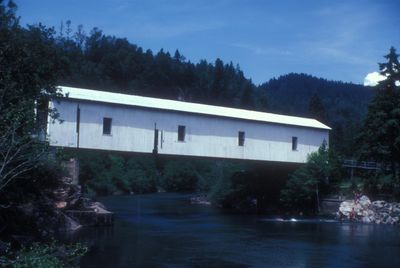
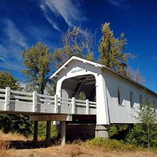
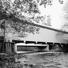
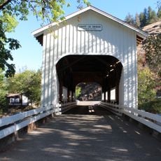
Milo Academy Bridge, Covered bridge in Days Creek, Oregon.

Description

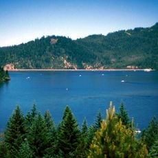
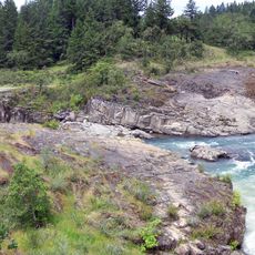
The Milo Academy Bridge is a covered bridge spanning the South Umpqua River in Days Creek that merges modern steel construction with a traditional wooden exterior. The structure includes four rectangular windows set into its gabled roof and sits on concrete supports at both riverbanks.

History

An original wooden bridge was built in 1920 and was later replaced in 1962 with a steel truss structure. Locals requested that the new bridge retain traditional wooden covering, so the modern frame was enclosed with a period-style exterior.

Culture

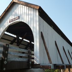
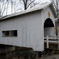
The bridge reflects how local communities valued preserving traditional character even when upgrading infrastructure. Today you can observe how the wooden exterior wraps around a modern structure beneath, showing this balance between old and new aesthetics.

Practical

This is a single-lane crossing, so oncoming traffic is possible when driving over it to reach Milo Adventist Academy. Pedestrians can walk across to view the structure, but remain alert to vehicles using the bridge for access to the school.

Did you know?

This bridge is unique as Oregon's only covered bridge where the wooden exterior serves a purely decorative purpose rather than providing structural support. The entire wooden shell was added to a completed steel structure simply to maintain visual continuity with local heritage.

Location
GPS coordinates
42.93560,-123.03700
Latest update
December 14, 2025 18:47

AroundUs brings together thousands of curated places, local tips, and hidden gems, enriched daily by 60,000 contributors worldwide. Discover all places nearby (Douglas County).

Around this place
Wildlife Safari
United States of America

Wildlife Safari

39.1 km
Lost Creek Lake
United States of America

Lost Creek Lake

42 km
Golden
United States of America

Golden

36.9 km
Wolf Creek Inn
United States of America

Wolf Creek Inn

39.7 km
Joseph H. Stewart State Recreation Area
United States of America

Joseph H. Stewart State Recreation Area

44.1 km
Colliding Rivers
United States of America

Colliding Rivers

40.7 km
Casey State Recreation Site
United States of America

Casey State Recreation Site

41.5 km
North Umpqua Trail
United States of America

North Umpqua Trail

43.7 km
Tiller Ranger Station
United States of America

Tiller Ranger Station

7.2 km
Grave Creek Bridge
United States of America

Grave Creek Bridge

43.4 km
Yakso Falls
United States of America

Yakso Falls

41.4 km
Methodist Episcopal Church South
United States of America

Methodist Episcopal Church South

39.2 km
Floed–Lane House
United States of America

Floed–Lane House

39.7 km
Horse Creek Bridge
United States of America

Horse Creek Bridge

22.8 km
Wimer Bridge
United States of America

Wimer Bridge

45.2 km
Neal Lane Bridge
United States of America

Neal Lane Bridge

21.4 km
Roseburg National Guard Armory
United States of America

Roseburg National Guard Armory

39.2 km
Judge James Watson Hamilton House
United States of America

Judge James Watson Hamilton House

39.1 km
James Wimer Octagonal Barn
United States of America

James Wimer Octagonal Barn

46.8 km
Canyonville United Methodist Church
United States of America

Canyonville United Methodist Church

19.8 km
Cavitt Creek Bridge
United States of America

Cavitt Creek Bridge

34.4 km
Glide Ranger Station
United States of America

Glide Ranger Station

40.7 km
U.S. Post Office
United States of America

U.S. Post Office

39.4 km
Whaleback Snow-Survey Cabin
United States of America

Whaleback Snow-Survey Cabin

37.3 km
Kohlhagen Building
United States of America

Kohlhagen Building

39.3 km
Oregon State Soldier's Home Hospital
United States of America

Oregon State Soldier's Home Hospital

41 km
Douglas County Museum
United States of America

Douglas County Museum

39 km
Red Mountain Lookout
United States of America

Red Mountain Lookout

7.2 km
Show the full map
« Milo Academy Bridge - Covered bridge in Days Creek, Oregon » is provided by Around Us (aroundus.com). Images and texts are derived from Wikimedia project under a Creative Commons license. You are allowed to copy, distribute, and modify copies of this page, under the conditions set by the license, as long as this note is clearly visible.

Discover hidden gems everywhere you go!

From secret cafés to breathtaking viewpoints, skip the crowded tourist spots and find places that match your style. Our app makes it easy with voice search, smart filtering, route optimization, and insider tips from travelers worldwide. Download now for the complete mobile experience.

Around Us App Screenshot

A unique approach to discovering new places

Le Figaro

All the places worth exploring

France Info

A tailor-made excursion in just a few clicks

20 Minutes

Around Us
Travel Guide & Maps
Download

Send to your phone

QR Code
1

Open the camera app on your mobile.

2

Point at the QR code with your camera. A notification will appear.

3

Tap the notification to open the link.