North Umpqua Trail

Log in to your account

AroundUs is a community-driven map of interesting places, built by curious explorers like you. It grows with every review, story, and photo you share.
Connect to save your favorite spots, contribute locations, and create personalized routes.
Continue with Google
Continue with Apple
Continue with X
Continue with Facebook
Continue with email
By continuing, you accept our Terms and Conditions and our Privacy Policy
Create an account

North Umpqua Trail

Add to collection
Map
Suggest a change
Share

North Umpqua Trail, Hiking trail network in Umpqua National Forest, Oregon.

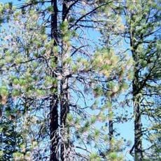
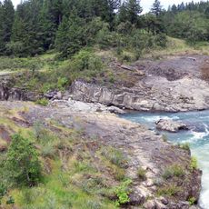
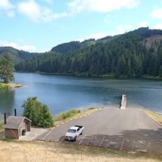
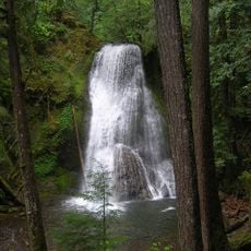
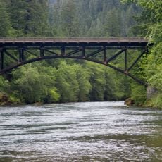
The North Umpqua Trail is a hiking network in Umpqua National Forest that follows the North Umpqua River through dense forests with numerous waterfalls and mountain views. The route is divided into multiple segments of varying lengths and difficulty levels, each offering different forest types and river scenery.

Indigenous peoples used these routes through the region for thousands of years before the modern trail system was developed. The formal network was established in recent decades to provide public access to these traditional travel corridors.

The trail network contains eleven segments that showcase the natural features of the Pacific Northwest through old-growth forests and river corridors.

The network offers options for different abilities, with both challenging multi-day routes and shorter day hikes available throughout the system. Sturdy footwear and weather protection are essential, as conditions in the dense forest can change quickly.

Individual segments were deliberately designed for different experience levels, ranging from strenuous mountain sections to leisurely river-side forest walks. This variety allows visitors of different fitness and skill levels to explore portions of the system.

Location: Oregon

GPS coordinates: 43.32760,-123.00400

Latest update: December 14, 2025 13:06

Photos
Around this place
Wildlife Safari
United States of America

Wildlife Safari

40 km
Boulder Creek Wilderness
United States of America

Boulder Creek Wilderness

39.5 km
Bohemia Mountain
United States of America

Bohemia Mountain

39.4 km
Colliding Rivers
United States of America

Colliding Rivers

8.6 km
Cooper Creek Reservoir
United States of America

Cooper Creek Reservoir

23.2 km
Musick Guard Station
United States of America

Musick Guard Station

40.7 km
Yakso Falls
United States of America

Yakso Falls

26 km
Methodist Episcopal Church South
United States of America

Methodist Episcopal Church South

30.7 km
Floed–Lane House
United States of America

Floed–Lane House

30.6 km
Milo Academy Bridge
United States of America

Milo Academy Bridge

43.7 km
Horse Creek Bridge
United States of America

Horse Creek Bridge

41.1 km
Neal Lane Bridge
United States of America

Neal Lane Bridge

41 km
Roseburg National Guard Armory
United States of America

Roseburg National Guard Armory

30.4 km
Rochester Covered Bridge
United States of America

Rochester Covered Bridge

30.2 km
Judge James Watson Hamilton House
United States of America

Judge James Watson Hamilton House

30.6 km
Cavitt Creek Bridge
United States of America

Cavitt Creek Bridge

9.4 km
Glide Ranger Station
United States of America

Glide Ranger Station

8.5 km
U.S. Post Office
United States of America

U.S. Post Office

30.8 km
Stearns Hardware Store
United States of America

Stearns Hardware Store

26 km
Oakland Historic District
United States of America

Oakland Historic District

26 km
Kohlhagen Building
United States of America

Kohlhagen Building

30.5 km
Oregon State Soldier's Home Hospital
United States of America

Oregon State Soldier's Home Hospital

32.1 km
Charles Applegate House
United States of America

Charles Applegate House

38.3 km
English Settlement School
United States of America

English Settlement School

24 km
Sutherlin Bank Building
United States of America

Sutherlin Bank Building

25.9 km
Mott Bridge
United States of America

Mott Bridge

21.9 km
Douglas County Museum
United States of America

Douglas County Museum

32.5 km
Oakland Bridge
United States of America

Oakland Bridge

26.5 km
Show the full map
Reviews

Visited this place? Tap the stars to rate it and share your experience / photos with the community! Try now! You can cancel it anytime.

« North Umpqua Trail - Hiking trail network in Umpqua National Forest, Oregon » is provided by Around Us (aroundus.com). Images and texts are derived from Wikimedia project under a Creative Commons license. You are allowed to copy, distribute, and modify copies of this page, under the conditions set by the license, as long as this note is clearly visible.

Discover hidden gems everywhere you go!

From secret cafés to breathtaking viewpoints, skip the crowded tourist spots and find places that match your style. Our app makes it easy with voice search, smart filtering, route optimization, and insider tips from travelers worldwide. Download now for the complete mobile experience.

Around Us App Screenshot

A unique approach to discovering new places

Le Figaro

All the places worth exploring

France Info

A tailor-made excursion in just a few clicks

20 Minutes