Enable Location

We need your location to show you interesting places around you

Discover nearby places

Find interesting locations and hidden gems around you

Precise directions

Get accurate directions and distances to places

Your location is never shared with other users. It's only used when you tap the location button.

Casey State Recreation Site

Log in to your account

Start exploring — it's free

Trusted by 63,029 travelers worldwide

Continue with Google
Continue with Apple
or

We will send you a code to connect

By continuing, you accept our Terms and Conditions and our Privacy Policy

Check your inbox

We've sent a pincode in your inbox. Please enter the code below.

Casey State Recreation Site
Discussion Reviews 1 Photos
2.3k Popularity

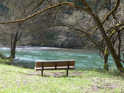
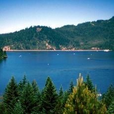
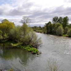
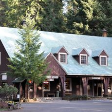
Casey State Recreation Site, State recreation site along Rogue River near Medford, Oregon, US.

Casey State Recreation Site is a recreation area along the Rogue River near Medford with open lawns, picnic tables, and grilling spots set beneath trees. The site includes a boat launch, walking trails, and parking areas designed for visitors spending time along the river.

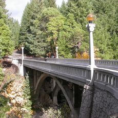
The federal government leased this land in 1932 and purchased it in 1937 after James Allen Casey operated a small restaurant and tourist camp there. During the 1930s, the Civilian Conservation Corps built parking areas, tables, grills, and walking trails on the site.

The Civilian Conservation Corps enhanced the site by constructing parking lots, tables, individual stoves, a boat ramp, and walking trails.

Bring your own drinking water since none is available on-site, and check current fishing regulations before planning any angling activities. The boat ramp is accessible for launching, and the walking paths are easy to navigate.

The site offers direct access to salmon, steelhead, and trout fishing spots along the Rogue River that are active during different seasons. Anglers can target multiple fish species as each has its own time of year when it is present.

The community of curious travelers

AroundUs brings together thousands of curated places, local tips, and hidden gems, enriched daily by 60,000 contributors worldwide.

Start exploring
Location
GPS coordinates
42.66010,-122.69400
Latest update
December 13, 2025 12:24
Around this place
Oregon Vortex
United States of America

Oregon Vortex

37.1 km
Mount McLoughlin
United States of America

Mount McLoughlin

39.2 km
Lost Creek Lake
United States of America

Lost Creek Lake

4.1 km
Sky Lakes Wilderness
United States of America

Sky Lakes Wilderness

38.2 km
Prospect State Scenic Viewpoint
United States of America

Prospect State Scenic Viewpoint

18.4 km
Medford Oregon Temple
United States of America

Medford Oregon Temple

37.5 km
Joseph H. Stewart State Recreation Area
United States of America

Joseph H. Stewart State Recreation Area

6.7 km
Agate Lake
United States of America

Agate Lake

28.4 km
TouVelle State Recreation Site
United States of America

TouVelle State Recreation Site

29.1 km
Mill Creek Falls
United States of America

Mill Creek Falls

18.5 km
Antelope Creek Bridge
United States of America

Antelope Creek Bridge

22.7 km
Lost Creek Bridge
United States of America

Lost Creek Bridge

32.6 km
Tiller Ranger Station
United States of America

Tiller Ranger Station

36.3 km
Conro Fiero House
United States of America

Conro Fiero House

34.8 km
Willow Prairie Cabin
United States of America

Willow Prairie Cabin

37.5 km
Imnaha Guard Station
United States of America

Imnaha Guard Station

30.1 km
Chavner Family House
United States of America

Chavner Family House

37.8 km
Fort Lane
United States of America

Fort Lane

34.8 km
Frank Chamberlain Clark House
United States of America

Frank Chamberlain Clark House

38.9 km
Wimer Bridge
United States of America

Wimer Bridge

39.7 km
Barnum Hotel
United States of America

Barnum Hotel

39.8 km
Union Creek Historic District
United States of America

Union Creek Historic District

34.1 km
Elks Lodge
United States of America

Elks Lodge

39.7 km
Whaleback Snow-Survey Cabin
United States of America

Whaleback Snow-Survey Cabin

29.4 km
Camp White Station Hospital Administration Building
United States of America

Camp White Station Hospital Administration Building

27.2 km
Red Mountain Lookout
United States of America

Red Mountain Lookout

36.2 km
Sparta Building
United States of America

Sparta Building

39.7 km
North Fork Rogue River Bridge
United States of America

North Fork Rogue River Bridge

18.8 km
Show the full map
Reviews
Share your experience

No review yet

Discussions
Start a discussion...

No discussion yet

« Casey State Recreation Site - State recreation site along Rogue River near Medford, Oregon, US » is provided by Around Us (aroundus.com). Images and texts are derived from Wikimedia project under a Creative Commons license. You are allowed to copy, distribute, and modify copies of this page, under the conditions set by the license, as long as this note is clearly visible.

Discover hidden gems everywhere you go!

From secret cafés to breathtaking viewpoints, skip the crowded tourist spots and find places that match your style. Our app makes it easy with voice search, smart filtering, route optimization, and insider tips from travelers worldwide. Download now for the complete mobile experience.

Around Us App Screenshot

A unique approach to discovering new places

Le Figaro

All the places worth exploring

France Info

A tailor-made excursion in just a few clicks

20 Minutes

Around Us
Travel Guide & Maps
Download

Send to your phone

QR Code
1

Open the camera app on your mobile.

2

Point at the QR code with your camera. A notification will appear.

3

Tap the notification to open the link.