Enable Location

We need your location to show you interesting places around you

Discover nearby places

Find interesting locations and hidden gems around you

Precise directions

Get accurate directions and distances to places

Your location is never shared with other users. It's only used when you tap the location button.

Mount McLoughlin

Log in to your account

Start exploring — it's free

Trusted by 62,397 travelers worldwide

Continue with Google
Continue with Apple
or

We will send you a code to connect

By continuing, you accept our Terms and Conditions and our Privacy Policy

Check your inbox

We've sent a pincode in your inbox. Please enter the code below.

Mount McLoughlin

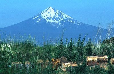
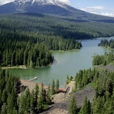
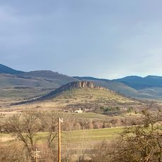
Mount McLoughlin, Steep stratovolcano in southern Oregon, United States.

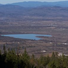
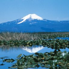
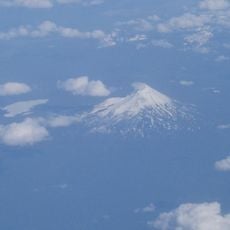
Mount McLoughlin is a stratovolcano in Jackson County that rises to 2,894 meters (9,495 feet) and is formed from andesite. The southern side shows a symmetrical cone, while the northern face exposes the inner workings of its volcanic core.

The peak took its current name in 1838 after John McLoughlin, who worked as chief administrator for the Hudson's Bay Company across the Pacific Northwest. This naming happened during active colonial times when trading routes through Oregon were being established.

The Takelma people called this peak Mal-sr and saw it as home to Tasuune, their Acorn Woman spirit. This connection shaped how communities in the region understood the mountain long before it received its current name.

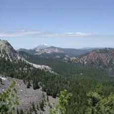
The summit trail covers around 8 kilometers (5 miles) through the Sky Lakes Wilderness and requires crampons and ice axes during winter months. Late spring through early fall offers better conditions once snowmelt progresses and trails become more accessible.

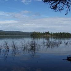
The western slopes supply drinking water to Medford as snowmelt feeds into Big Butte Springs. This process provides clean water for the city and makes this peak a working part of municipal infrastructure.

The community of curious travelers

AroundUs brings together thousands of curated places, local tips, and hidden gems, enriched daily by 60,000 contributors worldwide.

Start exploring
Location
Elevation above the sea
2,894 m
Made from material
andesite
GPS coordinates
42.44455,-122.31596
Latest update
December 20, 2025 12:02
Around this place
Train Mountain Railroad
United States of America

Train Mountain Railroad

37 km
Lost Creek Lake
United States of America

Lost Creek Lake

38.4 km
Fort Klamath
United States of America

Fort Klamath

39.3 km
Sky Lakes Wilderness
United States of America

Sky Lakes Wilderness

20.6 km
Emigrant Lake
United States of America

Emigrant Lake

39.4 km
Prospect State Scenic Viewpoint
United States of America

Prospect State Scenic Viewpoint

35.8 km
Fish Lake
United States of America

Fish Lake

7.9 km
Joseph H. Stewart State Recreation Area
United States of America

Joseph H. Stewart State Recreation Area

36.5 km
Mountain Lakes Wilderness
United States of America

Mountain Lakes Wilderness

20.6 km
Howard Prairie Lake
United States of America

Howard Prairie Lake

25.9 km
Agate Lake
United States of America

Agate Lake

37.5 km
Upper Klamath National Wildlife Refuge
United States of America

Upper Klamath National Wildlife Refuge

23.6 km
Fourmile Lake
United States of America

Fourmile Lake

5.6 km
Casey State Recreation Site
United States of America

Casey State Recreation Site

39.2 km
Tub Springs State Wayside
United States of America

Tub Springs State Wayside

37.9 km
Hyatt Reservoir
United States of America

Hyatt Reservoir

30.9 km
Mill Creek Falls
United States of America

Mill Creek Falls

36.1 km
Antelope Creek Bridge
United States of America

Antelope Creek Bridge

39.9 km
Lost Creek Bridge
United States of America

Lost Creek Bridge

22.8 km
Willow Prairie Cabin
United States of America

Willow Prairie Cabin

7.6 km
Dead Indian Soda Springs
United States of America

Dead Indian Soda Springs

16.6 km
Imnaha Guard Station
United States of America

Imnaha Guard Station

28.9 km
Lake of the Woods Ranger Station
United States of America

Lake of the Woods Ranger Station

9.7 km
Nils Ahlstrom House
United States of America

Nils Ahlstrom House

37.7 km
Honeymoon Creek Snow-Survey Cabin
United States of America

Honeymoon Creek Snow-Survey Cabin

26.7 km
Pompadour Bluff
United States of America

Pompadour Bluff

38.4 km
Fish Lake Shelter
United States of America

Fish Lake Shelter

5.7 km
North Fork Rogue River Bridge
United States of America

North Fork Rogue River Bridge

36.6 km
Show the full map
« Mount McLoughlin - Steep stratovolcano in southern Oregon, United States » is provided by Around Us (aroundus.com). Images and texts are derived from Wikimedia project under a Creative Commons license. You are allowed to copy, distribute, and modify copies of this page, under the conditions set by the license, as long as this note is clearly visible.

Discover hidden gems everywhere you go!

From secret cafés to breathtaking viewpoints, skip the crowded tourist spots and find places that match your style. Our app makes it easy with voice search, smart filtering, route optimization, and insider tips from travelers worldwide. Download now for the complete mobile experience.

Around Us App Screenshot

A unique approach to discovering new places

Le Figaro

All the places worth exploring

France Info

A tailor-made excursion in just a few clicks

20 Minutes

Around Us
Travel Guide & Maps
Download

Send to your phone

QR Code
1

Open the camera app on your mobile.

2

Point at the QR code with your camera. A notification will appear.

3

Tap the notification to open the link.