Enable Location

We need your location to show you interesting places around you

Discover nearby places

Find interesting locations and hidden gems around you

Precise directions

Get accurate directions and distances to places

Your location is never shared with other users. It's only used when you tap the location button.

Dead Indian Soda Springs

Log in to your account

Start exploring — it's free

Trusted by 62,397 travelers worldwide

Continue with Google
Continue with Apple
or

We will send you a code to connect

By continuing, you accept our Terms and Conditions and our Privacy Policy

Check your inbox

We've sent a pincode in your inbox. Please enter the code below.

Dead Indian Soda Springs, Mineral spring near Eagle Point, Oregon, United States.

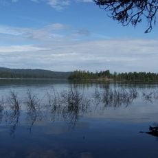
Dead Indian Soda Springs is a mineral water site near Eagle Point featuring several natural spring sources that feed into Dead Indian Creek. The waters carry sodium, iron, and magnesium compounds through the creek as it flows through the local landscape.

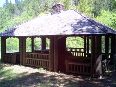
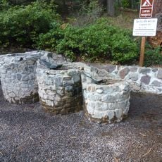
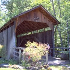
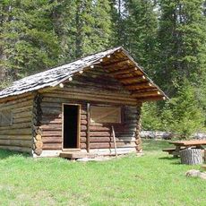
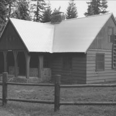
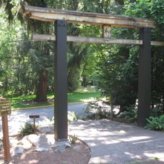
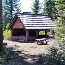
John Tyrell discovered the springs in 1871 while hunting elk, bringing attention to the location and its potential as a gathering place. During the 1930s, conservation workers developed the site with constructed features to improve access and enjoyment.

The name reflects a difficult chapter in local Native American history that shaped how people understand this place. Visitors who learn this history often develop a deeper respect for the land and its complex past.

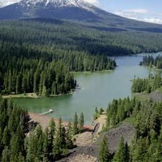
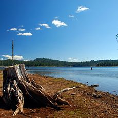
The site sits about 35 miles east of Medford in a wooded setting and is best reached by car. Visitors will find picnic areas, stone pathways, and walking routes that can be explored on foot throughout the grounds.

The site earned listing on the National Register of Historic Places in 2000 for its well-preserved examples of 1930s rustic architecture. This building style was designed to blend structures with the natural forest without drawing excessive attention.

The community of curious travelers

AroundUs brings together thousands of curated places, local tips, and hidden gems, enriched daily by 60,000 contributors worldwide.

Start exploring
Location
GPS coordinates
42.33220,-122.44800
Latest update
December 14, 2025 18:14
Around this place
Mount McLoughlin
United States of America

Mount McLoughlin

16.6 km
Lithia Park
United States of America

Lithia Park

27.2 km
Emigrant Lake
United States of America

Emigrant Lake

23 km
Ashland Springs Hotel
United States of America

Ashland Springs Hotel

26.6 km
Fish Lake
United States of America

Fish Lake

9.6 km
Allen Elizabethan Theatre
United States of America

Allen Elizabethan Theatre

26.7 km
Howard Prairie Lake
United States of America

Howard Prairie Lake

14.2 km
Fourmile Lake
United States of America

Fourmile Lake

21.8 km
Tub Springs State Wayside
United States of America

Tub Springs State Wayside

24.1 km
Hyatt Reservoir
United States of America

Hyatt Reservoir

16.3 km
Lost Creek Bridge
United States of America

Lost Creek Bridge

12 km
Willow Prairie Cabin
United States of America

Willow Prairie Cabin

9.4 km
Ashland Masonic Lodge Building
United States of America

Ashland Masonic Lodge Building

26.7 km
Lake of the Woods Ranger Station
United States of America

Lake of the Woods Ranger Station

19.2 km
First Baptist Church
United States of America

First Baptist Church

26.6 km
I.O.O.F. Building
United States of America

I.O.O.F. Building

26.7 km
Ashland Oregon National Guard Armory
United States of America

Ashland Oregon National Guard Armory

26.3 km
Ashland Hills Hotel and Suites
United States of America

Ashland Hills Hotel and Suites

24 km
ScienceWorks Museum
United States of America

ScienceWorks Museum

25.2 km
Japanese Garden
United States of America

Japanese Garden

27.3 km
Trinity Episcopal Church
United States of America

Trinity Episcopal Church

26.5 km
Nils Ahlstrom House
United States of America

Nils Ahlstrom House

24.3 km
Carter Memorial Fountain
United States of America

Carter Memorial Fountain

26.7 km
Pompadour Bluff
United States of America

Pompadour Bluff

21.9 km
Women's Civic Improvement Clubhouse
United States of America

Women's Civic Improvement Clubhouse

26.8 km
Varsity Theater
United States of America

Varsity Theater

26.6 km
Angus Bowmer Theatre
United States of America

Angus Bowmer Theatre

26.7 km
Fish Lake Shelter
United States of America

Fish Lake Shelter

12.7 km
Show the full map
« Dead Indian Soda Springs - Mineral spring near Eagle Point, Oregon, United States » is provided by Around Us (aroundus.com). Images and texts are derived from Wikimedia project under a Creative Commons license. You are allowed to copy, distribute, and modify copies of this page, under the conditions set by the license, as long as this note is clearly visible.

Discover hidden gems everywhere you go!

From secret cafés to breathtaking viewpoints, skip the crowded tourist spots and find places that match your style. Our app makes it easy with voice search, smart filtering, route optimization, and insider tips from travelers worldwide. Download now for the complete mobile experience.

Around Us App Screenshot

A unique approach to discovering new places

Le Figaro

All the places worth exploring

France Info

A tailor-made excursion in just a few clicks

20 Minutes

Around Us
Travel Guide & Maps
Download

Send to your phone

QR Code
1

Open the camera app on your mobile.

2

Point at the QR code with your camera. A notification will appear.

3

Tap the notification to open the link.