Enable Location

We need your location to show you interesting places around you

Discover nearby places

Find interesting locations and hidden gems around you

Precise directions

Get accurate directions and distances to places

Your location is never shared with other users. It's only used when you tap the location button.

Lake of the Woods Ranger Station

Log in to your account

Start exploring — it's free

Trusted by 62,386 travelers worldwide

Continue with Google
Continue with Apple
or

We will send you a code to connect

By continuing, you accept our Terms and Conditions and our Privacy Policy

Check your inbox

We've sent a pincode in your inbox. Please enter the code below.

Lake of the Woods Ranger Station, distrikt historik në Shtetet e Bashkuara

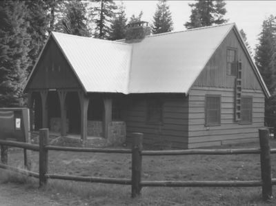
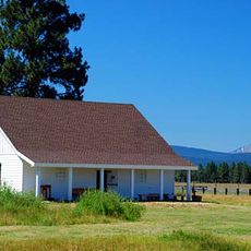
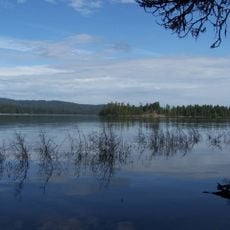
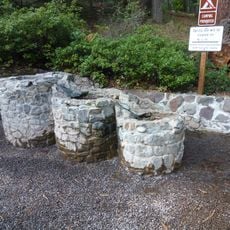
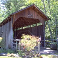
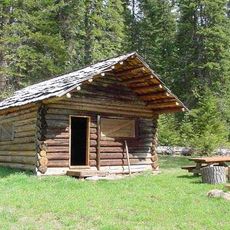
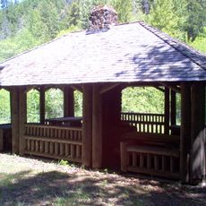
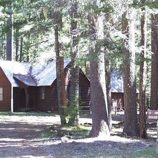
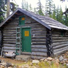
Lake of the Woods Ranger Station is a complex of eight buildings constructed between 1937 and 1939 in a forested area overlooking a lake in Klamath County, Oregon. The structures use horizontal boards, wood shingles, and natural stone, with a central office building featuring knotty-pine walls and a large stone fireplace, along with ranger residences, a crew house, a garage, and a barn built from peeled logs.

The ranger station was built from 1937 to 1939 by the Civilian Conservation Corps, an employment program during the Great Depression. These stations served as bases for forest workers in remote areas and helped with fire protection and resource management in forest reserves originally established in 1898.

The buildings reflect a practical connection to forest work, with pine tree cutouts on the gables symbolizing the Forest Service's relationship with the surrounding woods. The local materials and simple design show how workers lived and operated in close harmony with the landscape they managed.

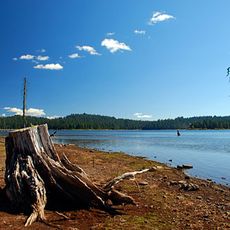
The ranger station sits at about 5,000 feet elevation near Lake of the Woods and is easily accessible from Oregon Route 140, with parking available near the buildings. The site can be explored on foot, and the old office building serves as a visitor center during summer months with exhibits about forest history and work.

A barn structure was built from peeled logs with a gambrel roof, standing out distinctly from the other buildings in its rustic character. This unusual construction method shows the practical craftsmanship of forest workers who used materials readily available on site.

The community of curious travelers

AroundUs brings together thousands of curated places, local tips, and hidden gems, enriched daily by 60,000 contributors worldwide.

Start exploring
Location
Architects
United States Forest Service
Architectural style
Forest Service rustic
GPS coordinates
42.38670,-122.22700
Latest update
February 9, 2026 07:40
Around this place
Mount McLoughlin
United States of America

Mount McLoughlin

9.7 km
Train Mountain Railroad
United States of America

Train Mountain Railroad

33.9 km
Fort Klamath
United States of America

Fort Klamath

39.8 km
Link River Dam
United States of America

Link River Dam

38.9 km
Sky Lakes Wilderness
United States of America

Sky Lakes Wilderness

25.8 km
Emigrant Lake
United States of America

Emigrant Lake

39.9 km
Collier Memorial State Park
United States of America

Collier Memorial State Park

40.2 km
Fish Lake
United States of America

Fish Lake

10 km
John C. Boyle Dam
United States of America

John C. Boyle Dam

32.8 km
Mountain Lakes Wilderness
United States of America

Mountain Lakes Wilderness

11.2 km
Howard Prairie Lake
United States of America

Howard Prairie Lake

22.6 km
Upper Klamath National Wildlife Refuge
United States of America

Upper Klamath National Wildlife Refuge

20.4 km
Fourmile Lake
United States of America

Fourmile Lake

9.1 km
Tub Springs State Wayside
United States of America

Tub Springs State Wayside

34.8 km
Hyatt Reservoir
United States of America

Hyatt Reservoir

29.1 km
Baldwin Hotel
United States of America

Baldwin Hotel

40.7 km
Lost Creek Bridge
United States of America

Lost Creek Bridge

29 km
Willow Prairie Cabin
United States of America

Willow Prairie Cabin

13.8 km
Dead Indian Soda Springs
United States of America

Dead Indian Soda Springs

19.2 km
Imnaha Guard Station
United States of America

Imnaha Guard Station

36.4 km
Klamath Falls City Hall
United States of America

Klamath Falls City Hall

41 km
Nils Ahlstrom House
United States of America

Nils Ahlstrom House

34.2 km
Judge Henry L. Benson House
United States of America

Judge Henry L. Benson House

40.6 km
Honeymoon Creek Snow-Survey Cabin
United States of America

Honeymoon Creek Snow-Survey Cabin

31.4 km
Richardson–Ulrich House
United States of America

Richardson–Ulrich House

40.1 km
Pompadour Bluff
United States of America

Pompadour Bluff

40.2 km
Klamath County Museum
United States of America

Klamath County Museum

41.2 km
Ross Ragland Theatre
United States of America

Ross Ragland Theatre

40.7 km
Show the full map
« Lake of the Woods Ranger Station - distrikt historik në Shtetet e Bashkuara » is provided by Around Us (aroundus.com). Images and texts are derived from Wikimedia project under a Creative Commons license. You are allowed to copy, distribute, and modify copies of this page, under the conditions set by the license, as long as this note is clearly visible.

Discover hidden gems everywhere you go!

From secret cafés to breathtaking viewpoints, skip the crowded tourist spots and find places that match your style. Our app makes it easy with voice search, smart filtering, route optimization, and insider tips from travelers worldwide. Download now for the complete mobile experience.

Around Us App Screenshot

A unique approach to discovering new places

Le Figaro

All the places worth exploring

France Info

A tailor-made excursion in just a few clicks

20 Minutes

Around Us
Travel Guide & Maps
Download

Send to your phone

QR Code
1

Open the camera app on your mobile.

2

Point at the QR code with your camera. A notification will appear.

3

Tap the notification to open the link.