John C. Boyle Dam

Log in to your account

AroundUs is a community-driven map of interesting places, built by curious explorers like you. It grows with every review, story, and photo you share.
Connect to save your favorite spots, contribute locations, and create personalized routes.
Continue with Google
Continue with Apple
Continue with X
Continue with Facebook
Continue with email
By continuing, you accept our Terms and Conditions and our Privacy Policy
Create an account
Add to collection
Map
Suggest a change
Share

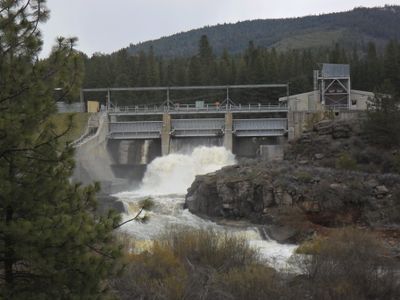
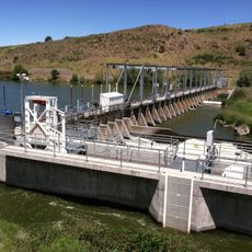
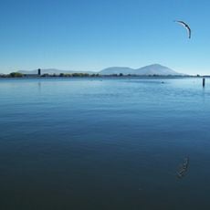
John C. Boyle Dam, Embankment gravity dam in Klamath County, US.

The John C. Boyle Dam was a concrete structure that stretched across the Klamath River and incorporated an earthen section designed for water storage and electricity generation. The facility included three spillway gates, fish screens, and a fish ladder that worked together to manage flow and protect aquatic life.

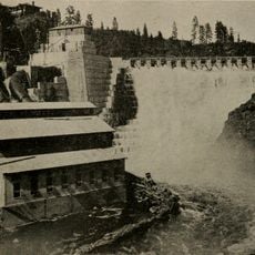
Built from 1956 to 1958, the dam was part of a broader hydroelectric project designed to power the region with renewable energy. In 2024, the structure was decommissioned and removed, marking a significant reversal in the region's approach to river management.

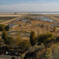
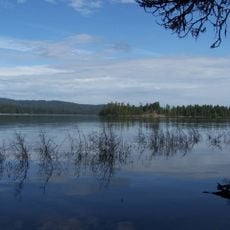
The dam's removal in 2024 marked a turning point in how the region views waterways, with communities embracing the restoration of the river and its natural processes. This shift reflected growing recognition that returning the river to its original state could benefit both local ecosystems and future generations.

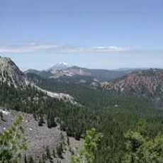
Information about the removal process and ongoing restoration efforts is available through local sources and regional water management agencies. Visiting the site today shows the area in transition as the river begins to reclaim its natural form.

The dam removal was one of the largest infrastructure removal projects completed in the western United States focused on river restoration. This event marked a dramatic shift in how society balances energy needs with environmental recovery.

Location: Klamath County

GPS coordinates: 42.12350,-122.04800

Latest update: December 12, 2025 12:02

Photos
Around this place
Mount McLoughlin
United States of America

Mount McLoughlin

42 km
Lower Klamath National Wildlife Refuge
United States of America

Lower Klamath National Wildlife Refuge

34.9 km
Copco Lake
United States of America

Copco Lake

26.6 km
Link River Dam
United States of America

Link River Dam

23.7 km
Tule Lake National Wildlife Refuge
United States of America

Tule Lake National Wildlife Refuge

53 km
OC&E Woods Line State Trail
United States of America

OC&E Woods Line State Trail

26.2 km
Fish Lake
United States of America

Fish Lake

37.6 km
Lake Ewauna
United States of America

Lake Ewauna

24.4 km
Mountain Lakes Wilderness
United States of America

Mountain Lakes Wilderness

25.6 km
Howard Prairie Lake
United States of America

Howard Prairie Lake

29 km
Soda Mountain Wilderness
United States of America

Soda Mountain Wilderness

35.5 km
Bear Valley National Wildlife Refuge
United States of America

Bear Valley National Wildlife Refuge

14.6 km
Upper Klamath National Wildlife Refuge
United States of America

Upper Klamath National Wildlife Refuge

42.8 km
Fourmile Lake
United States of America

Fourmile Lake

41.7 km
Klamath Basin National Wildlife Refuge Complex
United States of America

Klamath Basin National Wildlife Refuge Complex

44.5 km
Tub Springs State Wayside
United States of America

Tub Springs State Wayside

32.1 km
Hyatt Reservoir
United States of America

Hyatt Reservoir

34.2 km
Baldwin Hotel
United States of America

Baldwin Hotel

24.1 km
Willow Prairie Cabin
United States of America

Willow Prairie Cabin

42.4 km
Dead Indian Soda Springs
United States of America

Dead Indian Soda Springs

40.3 km
Lake of the Woods Ranger Station
United States of America

Lake of the Woods Ranger Station

32.8 km
Klamath Falls City Hall
United States of America

Klamath Falls City Hall

24.7 km
Nils Ahlstrom House
United States of America

Nils Ahlstrom House

30.9 km
Blackburn Sanitarium
United States of America

Blackburn Sanitarium

25.8 km
Judge Henry L. Benson House
United States of America

Judge Henry L. Benson House

24.4 km
Richardson–Ulrich House
United States of America

Richardson–Ulrich House

23.8 km
Klamath County Museum
United States of America

Klamath County Museum

25.4 km
Ross Ragland Theatre
United States of America

Ross Ragland Theatre

24.7 km
Show the full map
Reviews

Visited this place? Tap the stars to rate it and share your experience / photos with the community! Try now! You can cancel it anytime.

« John C. Boyle Dam - Embankment gravity dam in Klamath County, US » is provided by Around Us (aroundus.com). Images and texts are derived from Wikimedia project under a Creative Commons license. You are allowed to copy, distribute, and modify copies of this page, under the conditions set by the license, as long as this note is clearly visible.

Discover hidden gems everywhere you go!

From secret cafés to breathtaking viewpoints, skip the crowded tourist spots and find places that match your style. Our app makes it easy with voice search, smart filtering, route optimization, and insider tips from travelers worldwide. Download now for the complete mobile experience.

Around Us App Screenshot

A unique approach to discovering new places

Le Figaro

All the places worth exploring

France Info

A tailor-made excursion in just a few clicks

20 Minutes