Enable Location

We need your location to show you interesting places around you

Discover nearby places

Find interesting locations and hidden gems around you

Precise directions

Get accurate directions and distances to places

Your location is never shared with other users. It's only used when you tap the location button.

Mill Creek Falls

Log in to your account

Start exploring — it's free

Trusted by 63,038 travelers worldwide

Continue with Google
Continue with Apple
or

We will send you a code to connect

By continuing, you accept our Terms and Conditions and our Privacy Policy

Check your inbox

We've sent a pincode in your inbox. Please enter the code below.

Mill Creek Falls
Discussion Reviews 1 Photos
1.7k Popularity

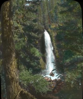
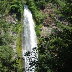
Mill Creek Falls, Double waterfall in Prospect State Scenic Viewpoint, Oregon, US.

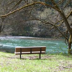
Mill Creek Falls is a double waterfall within Prospect State Scenic Viewpoint that shares a carved rock face with Barr Creek Falls. Both cascades plunge into the Rogue River Canyon through a dramatic slot in the stone.

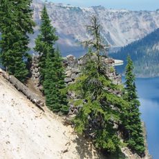
The rock formations around the falls contain layers of petrified volcanic ash from Mount Mazama's eruption thousands of years ago. This ancient geological event shaped the canyon and the cliff formations visitors see today.

The Mill Creek Falls Scenic Area incorporates viewing platforms and trail systems developed by Boise Cascade Corporation to enhance public access to natural landmarks.

A short trail of roughly half a mile departs from the parking area on Mill Creek Drive to reach observation platforms overlooking the falls. Multiple viewpoints along the route allow visitors to see both cascades from different angles.

The water flows year-round at a constant rate, keeping the falls forceful even during dry months when other regional waterfalls diminish. This reliable flow comes from mountain springs and snowmelt higher up in the watershed.

The community of curious travelers

AroundUs brings together thousands of curated places, local tips, and hidden gems, enriched daily by 60,000 contributors worldwide.

Start exploring
GPS coordinates
42.74028,-122.49528
Latest update
December 14, 2025 13:07
Around this place
Crater Lake Lodge
United States of America

Crater Lake Lodge

34.6 km
Lost Creek Lake
United States of America

Lost Creek Lake

14.5 km
Rim Village Historic District
United States of America

Rim Village Historic District

34.4 km
Sky Lakes Wilderness
United States of America

Sky Lakes Wilderness

25.5 km
Prospect State Scenic Viewpoint
United States of America

Prospect State Scenic Viewpoint

276 m
Joseph H. Stewart State Recreation Area
United States of America

Joseph H. Stewart State Recreation Area

11.9 km
Watchman Lookout Station
United States of America

Watchman Lookout Station

34.7 km
Union Peak
United States of America

Union Peak

24.4 km
Casey State Recreation Site
United States of America

Casey State Recreation Site

18.5 km
Sinnott Memorial Observation Station
United States of America

Sinnott Memorial Observation Station

34.5 km
Comfort Station No. 72
United States of America

Comfort Station No. 72

34.2 km
Crater Lake Superintendent's Residence
United States of America

Crater Lake Superintendent's Residence

34.2 km
Comfort Station No. 68
United States of America

Comfort Station No. 68

34.3 km
Munson Valley Historic District
United States of America

Munson Valley Historic District

34.3 km
Imnaha Guard Station
United States of America

Imnaha Guard Station

14 km
Union Creek Historic District
United States of America

Union Creek Historic District

19 km
Hershberger Mountain Lookout
United States of America

Hershberger Mountain Lookout

32.8 km
Whaleback Snow-Survey Cabin
United States of America

Whaleback Snow-Survey Cabin

20.3 km
Honeymoon Creek Snow-Survey Cabin
United States of America

Honeymoon Creek Snow-Survey Cabin

25.7 km
Rim Drive Historic District
United States of America

Rim Drive Historic District

34.6 km
Castle Crest Wildflower Trail
United States of America

Castle Crest Wildflower Trail

34.3 km
Administration Building
United States of America

Administration Building

34.3 km
Rim Visitor Center
United States of America

Rim Visitor Center

34.5 km
Watchman Peak Trail
United States of America

Watchman Peak Trail

34.6 km
Steel Visitor Center
United States of America

Steel Visitor Center

34.2 km
Discovery Point
United States of America

Discovery Point

33.8 km
Mess Hall
United States of America

Mess Hall

34.2 km
North Fork Rogue River Bridge
United States of America

North Fork Rogue River Bridge

611 m
Show the full map
Reviews
Share your experience

No review yet

Discussions
Start a discussion...

No discussion yet

« Mill Creek Falls - Double waterfall in Prospect State Scenic Viewpoint, Oregon, US » is provided by Around Us (aroundus.com). Images and texts are derived from Wikimedia project under a Creative Commons license. You are allowed to copy, distribute, and modify copies of this page, under the conditions set by the license, as long as this note is clearly visible.

Discover hidden gems everywhere you go!

From secret cafés to breathtaking viewpoints, skip the crowded tourist spots and find places that match your style. Our app makes it easy with voice search, smart filtering, route optimization, and insider tips from travelers worldwide. Download now for the complete mobile experience.

Around Us App Screenshot

A unique approach to discovering new places

Le Figaro

All the places worth exploring

France Info

A tailor-made excursion in just a few clicks

20 Minutes

Around Us
Travel Guide & Maps
Download

Send to your phone

QR Code
1

Open the camera app on your mobile.

2

Point at the QR code with your camera. A notification will appear.

3

Tap the notification to open the link.