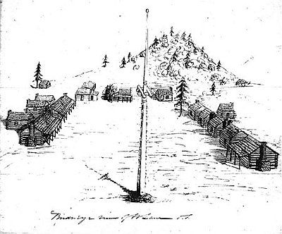
Enable Location

We need your location to show you interesting places around you

Discover nearby places

Find interesting locations and hidden gems around you

Precise directions

Get accurate directions and distances to places

Your location is never shared with other users. It's only used when you tap the location button.

Fort Lane

Log in to your account

Start exploring — it's free

Trusted by 62,408 travelers worldwide

Continue with Google
Continue with Apple
or

We will send you a code to connect

By continuing, you accept our Terms and Conditions and our Privacy Policy

Check your inbox

We've sent a pincode in your inbox. Please enter the code below.

Fort Lane

Fort Lane is a historic military fort in Oregon built in 1853 and listed on the National Register of Historic Places. The site is marked by a monument placed along Gold Ray Road in 1929 by the Daughters of the American Revolution, and is now managed by the Oregon Parks and Recreation Department.

The fort was established in 1853 under Captain Andrew Jackson Smith's command to control the region during the Rogue River War. It later served as a holding facility for Native Americans before being abandoned in 1856.

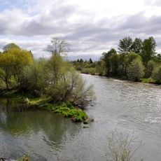
The site is visible from Gold Ray Road, though binoculars or a camera zoom lens can help with viewing. The interior is closed to visitors to protect artifacts, but the monument and plaque are accessible from the road.

Joseph Lane, whom the fort was named after, negotiated a peace treaty with the Takelma, Latgawa, Shasta, and Athabaskan peoples in the same year the fort was founded. Just two years later, a settler attack sparked violence that quickly shattered this fragile agreement.

The community of curious travelers

AroundUs brings together thousands of curated places, local tips, and hidden gems, enriched daily by 60,000 contributors worldwide.

Start exploring
Location
GPS coordinates
42.42661,-122.97697
Latest update
February 9, 2026 07:43
Around this place
Oregon Vortex
United States of America

Oregon Vortex

11.6 km
Valley of the Rogue State Park
United States of America

Valley of the Rogue State Park

14.3 km
Medford Oregon Temple
United States of America

Medford Oregon Temple

6.9 km
Bear Creek Greenway
United States of America

Bear Creek Greenway

21.6 km
Agate Lake
United States of America

Agate Lake

17.1 km
TouVelle State Recreation Site
United States of America

TouVelle State Recreation Site

7.4 km
Jacksonville Historic District
United States of America

Jacksonville Historic District

12.7 km
US Cellular Community Park
United States of America

US Cellular Community Park

17.4 km
Holly Theatre
United States of America

Holly Theatre

14 km
Medford Carnegie Library
United States of America

Medford Carnegie Library

14.1 km
Antelope Creek Bridge
United States of America

Antelope Creek Bridge

15.4 km
James A. Redden Federal Courthouse
United States of America

James A. Redden Federal Courthouse

13.9 km
Patrick F. McManus House
United States of America

Patrick F. McManus House

21.7 km
Conro Fiero House
United States of America

Conro Fiero House

8.4 km
Chavner Family House
United States of America

Chavner Family House

4.7 km
Jackson County Courthouse
United States of America

Jackson County Courthouse

14.1 km
Frank Chamberlain Clark House
United States of America

Frank Chamberlain Clark House

15.3 km
Wimer Bridge
United States of America

Wimer Bridge

18.9 km
Barnum Hotel
United States of America

Barnum Hotel

13.9 km
Newman United Methodist Church
United States of America

Newman United Methodist Church

28.5 km
Jackson County Courthouse
United States of America

Jackson County Courthouse

12.5 km
Elks Lodge
United States of America

Elks Lodge

13.8 km
John and Susanna Ahlf House
United States of America

John and Susanna Ahlf House

28.6 km
Cornelius C. Beekman House
United States of America

Cornelius C. Beekman House

12.7 km
Craterian Theater
United States of America

Craterian Theater

14.1 km
Camp White Station Hospital Administration Building
United States of America

Camp White Station Hospital Administration Building

11.3 km
Bear Hotel
United States of America

Bear Hotel

26.2 km
Sparta Building
United States of America

Sparta Building

14.1 km
Show the full map
« Fort Lane » is provided by Around Us (aroundus.com). Images and texts are derived from Wikimedia project under a Creative Commons license. You are allowed to copy, distribute, and modify copies of this page, under the conditions set by the license, as long as this note is clearly visible.

Discover hidden gems everywhere you go!

From secret cafés to breathtaking viewpoints, skip the crowded tourist spots and find places that match your style. Our app makes it easy with voice search, smart filtering, route optimization, and insider tips from travelers worldwide. Download now for the complete mobile experience.

Around Us App Screenshot

A unique approach to discovering new places

Le Figaro

All the places worth exploring

France Info

A tailor-made excursion in just a few clicks

20 Minutes

Around Us
Travel Guide & Maps
Download

Send to your phone

QR Code
1

Open the camera app on your mobile.

2

Point at the QR code with your camera. A notification will appear.

3

Tap the notification to open the link.