Enable Location

We need your location to show you interesting places around you

Discover nearby places

Find interesting locations and hidden gems around you

Precise directions

Get accurate directions and distances to places

Your location is never shared with other users. It's only used when you tap the location button.

Kohlreiter Square

Log in to your account

Start exploring — it's free

Trusted by 63,044 travelers worldwide

Continue with Google
Continue with Apple
or

We will send you a code to connect

By continuing, you accept our Terms and Conditions and our Privacy Policy

Check your inbox

We've sent a pincode in your inbox. Please enter the code below.

Kohlreiter Square
Discussion Reviews 1 Photos
2.6k Popularity

Kohlreiter Square, Public green space in Arverne, Queens, US

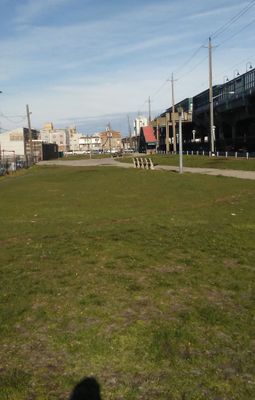
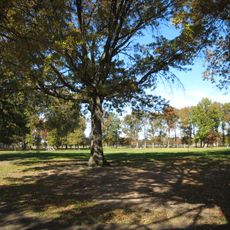
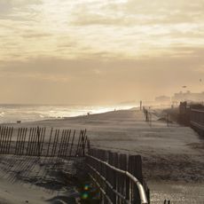
Kohlreiter Square is a public green space of approximately 8.6 acres located in Arverne along the north side of Rockaway Freeway between Beach 67th and Beach 69th Streets. The grounds spread across a flat, open layout with various areas designed for pedestrian use.

The site began as a plaza for the Arverne-Gaston Avenue Long Island Railroad station, which opened in 1887 during the development of Arverne-By-The-Sea. Its transformation into public parkland took place in 1946 when the city acquired the property from the railroad.

The square is named after Nathan A. Kohlreiter and his son Fred, two local citizens who shaped the area through their civic work. Their names remain connected to how people remember this part of Queens.

The square is accessible by public transportation with both subway and bus connections available along Rockaway Freeway. Plan your visit during daylight hours and keep in mind the proximity of the main road that runs alongside the grounds.

The square remains relatively unknown despite its foundation in a historic railroad station that served early 20th century coastal development. Visitors often overlook the connection between this modern green space and its past as a transportation hub.

The community of curious travelers

AroundUs brings together thousands of curated places, local tips, and hidden gems, enriched daily by 60,000 contributors worldwide.

Start exploring
Location
GPS coordinates
40.59117,-73.79657
Latest update
December 12, 2025 17:47
Around this place
Jacob Riis Park
United States of America

Jacob Riis Park

7.1 km
Fort Tilden
United States of America

Fort Tilden

9 km
Marine Parkway-Gil Hodges Memorial Bridge
United States of America

Marine Parkway-Gil Hodges Memorial Bridge

7.7 km
Baisley Park Houses
United States of America

Baisley Park Houses

10.5 km
Shirley Chisholm State Park
United States of America

Shirley Chisholm State Park

8.8 km
Christian Cultural Center
United States of America

Christian Cultural Center

10.2 km
Cross Bay Veterans Memorial Bridge
United States of America

Cross Bay Veterans Memorial Bridge

1.9 km
Spring Creek Park
United States of America

Spring Creek Park

8 km
Marine Park
United States of America

Marine Park

10.5 km
Atlantic Beach Bridge
United States of America

Atlantic Beach Bridge

5 km
Far Rockaway Beach Bungalow Historic District
United States of America

Far Rockaway Beach Bungalow Historic District

3.3 km
Mill Basin Bridge
United States of America

Mill Basin Bridge

8.8 km
Congregation Aish Kodesh
United States of America

Congregation Aish Kodesh

8.4 km
Joseph P. Addabbo Memorial Bridge
United States of America

Joseph P. Addabbo Memorial Bridge

6.5 km
Springfield Park
United States of America

Springfield Park

8.4 km
Rock Hall
United States of America

Rock Hall

5.6 km
First Presbyterian Church of Far Rockaway
United States of America

First Presbyterian Church of Far Rockaway

4.6 km
Temple of Israel Synagogue
United States of America

Temple of Israel Synagogue

1.2 km
Cobble Villa
United States of America

Cobble Villa

10.5 km
Rockaway Courthouse
United States of America

Rockaway Courthouse

1.7 km
Hook Creek Bridge
United States of America

Hook Creek Bridge

6.8 km
Samuel Vaisberg House
United States of America

Samuel Vaisberg House

10.5 km
Trinity Chapel
United States of America

Trinity Chapel

4.1 km
Rockaway Beach
United States of America

Rockaway Beach

5.1 km
Pauline Felix House
United States of America

Pauline Felix House

10.5 km
Jamaica Bay Wildlife Refuge
United States of America

Jamaica Bay Wildlife Refuge

4 km
Rock Hall Museum
United States of America

Rock Hall Museum

5.6 km
House at 226 West Penn Street
United States of America

House at 226 West Penn Street

10.6 km
Show the full map
Reviews
Share your experience

No review yet

Discussions
Start a discussion...

No discussion yet

« Kohlreiter Square - Public green space in Arverne, Queens, US » is provided by Around Us (aroundus.com). Images and texts are derived from Wikimedia project under a Creative Commons license. You are allowed to copy, distribute, and modify copies of this page, under the conditions set by the license, as long as this note is clearly visible.

Discover hidden gems everywhere you go!

From secret cafés to breathtaking viewpoints, skip the crowded tourist spots and find places that match your style. Our app makes it easy with voice search, smart filtering, route optimization, and insider tips from travelers worldwide. Download now for the complete mobile experience.

Around Us App Screenshot

A unique approach to discovering new places

Le Figaro

All the places worth exploring

France Info

A tailor-made excursion in just a few clicks

20 Minutes

Around Us
Travel Guide & Maps
Download

Send to your phone

QR Code
1

Open the camera app on your mobile.

2

Point at the QR code with your camera. A notification will appear.

3

Tap the notification to open the link.