Enable Location

We need your location to show you interesting places around you

Discover nearby places

Find interesting locations and hidden gems around you

Precise directions

Get accurate directions and distances to places

Your location is never shared with other users. It's only used when you tap the location button.

Shell Rock Bridge

Log in to your account

Start exploring — it's free

Trusted by 62,838 travelers worldwide

Continue with Google
Continue with Apple
or

We will send you a code to connect

By continuing, you accept our Terms and Conditions and our Privacy Policy

Check your inbox

We've sent a pincode in your inbox. Please enter the code below.

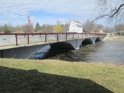
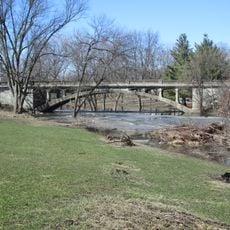
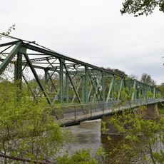
Shell Rock Bridge, Historic concrete arch bridge in Shell Rock, Iowa, United States.

The Shell Rock Bridge is a three-span concrete filled spandrel arch structure measuring 266 feet in length and 24 feet in width, featuring curved wing walls and handrails that extend across the full street width over the Shell Rock River.

Constructed in 1915 by Miller-Hey Construction Company under Iowa State Highway Commission plans, the bridge cost approximately $16,500 and was completed by November as part of Butler County's infrastructure improvement initiative.

Listed on the National Register of Historic Places, the bridge represents early 20th-century engineering excellence and serves as a symbol of regional development during the automobile expansion era for the Shell Rock community.

Located on Cherry Street in Shell Rock Township, the bridge remains open to vehicular traffic with routine maintenance inspections ensuring structural integrity while adhering to historic preservation standards for any modifications.

The bridge retains its original builder's plates and displays the year '1915' cast into the keystone of each span, maintaining exceptional physical integrity after more than a century of continuous service.

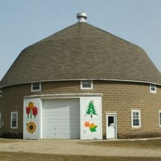
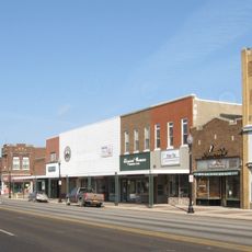
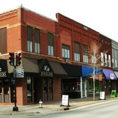
The community of curious travelers

AroundUs brings together thousands of curated places, local tips, and hidden gems, enriched daily by 60,000 contributors worldwide.

Start exploring
Location
Architects
Iowa Department of Transportation
GPS coordinates
42.71111,-92.58139
Latest update
July 25, 2025 19:49
Around this place
Wartburg College
United States of America

Wartburg College

8.4 km
UNI-Dome
United States of America

UNI-Dome

23.7 km
McElroy Auditorium
United States of America

McElroy Auditorium

28.2 km
United States of America

Waverly Public Library

7.7 km
Black Hawk Hotel
United States of America

Black Hawk Hotel

22.3 km
Cedar Falls Ice House
United States of America

Cedar Falls Ice House

22.1 km
Hartman Reserve Nature Center
United States of America

Hartman Reserve Nature Center

25.4 km
United States of America

Sans Souci Island

27.8 km
Sturdevant Southwest Historic District
United States of America

Sturdevant Southwest Historic District

8.8 km
Bremer County Court House
United States of America

Bremer County Court House

9.7 km
Cotton Theatre
United States of America

Cotton Theatre

22.4 km
Cedar Falls Independent Order of Odd Fellows
United States of America

Cedar Falls Independent Order of Odd Fellows

22.6 km
Old Main
United States of America

Old Main

8.4 km
Butler County Courthouse
United States of America

Butler County Courthouse

18.2 km
Cherry Street Bridge
United States of America

Cherry Street Bridge

504 m
Waverly House
United States of America

Waverly House

8.8 km
Charles H. & Theresa H. McBride Bungalow
United States of America

Charles H. & Theresa H. McBride Bungalow

277 m
C.A. Rownd Round Barn
United States of America

C.A. Rownd Round Barn

25.7 km
Waverly East Bremer Avenue Commercial Historic District
United States of America

Waverly East Bremer Avenue Commercial Historic District

9.3 km
Third Street Bridge
United States of America

Third Street Bridge

9.4 km
Cedar Falls Downtown Historic District
United States of America

Cedar Falls Downtown Historic District

22.4 km
Old Cedar Falls Post Office
United States of America

Old Cedar Falls Post Office

22.4 km
Bennington No. 4
United States of America

Bennington No. 4

26.4 km
Waverly Municipal Hydroelectric Powerhouse
United States of America

Waverly Municipal Hydroelectric Powerhouse

9.3 km
Round Barn
United States of America

Round Barn

17.1 km
Daniel and Margaret Wild House
United States of America

Daniel and Margaret Wild House

22 km
Old Fourth Ward Southeast Historic District
United States of America

Old Fourth Ward Southeast Historic District

9.4 km
Harmon and LeValley Northwest Historic District
United States of America

Harmon and LeValley Northwest Historic District

9.1 km
Show the full map
« Shell Rock Bridge - Historic concrete arch bridge in Shell Rock, Iowa, United States » is provided by Around Us (aroundus.com). Images and texts are derived from Wikimedia project under a Creative Commons license. You are allowed to copy, distribute, and modify copies of this page, under the conditions set by the license, as long as this note is clearly visible.

Discover hidden gems everywhere you go!

From secret cafés to breathtaking viewpoints, skip the crowded tourist spots and find places that match your style. Our app makes it easy with voice search, smart filtering, route optimization, and insider tips from travelers worldwide. Download now for the complete mobile experience.

Around Us App Screenshot

A unique approach to discovering new places

Le Figaro

All the places worth exploring

France Info

A tailor-made excursion in just a few clicks

20 Minutes

Around Us
Travel Guide & Maps
Download

Send to your phone

QR Code
1

Open the camera app on your mobile.

2

Point at the QR code with your camera. A notification will appear.

3

Tap the notification to open the link.