Enable Location

We need your location to show you interesting places around you

Discover nearby places

Find interesting locations and hidden gems around you

Precise directions

Get accurate directions and distances to places

Your location is never shared with other users. It's only used when you tap the location button.

Cooley Covered Bridge

Log in to your account

Start exploring — it's free

Trusted by 62,370 travelers worldwide

Continue with Google
Continue with Apple
or

We will send you a code to connect

By continuing, you accept our Terms and Conditions and our Privacy Policy

Check your inbox

We've sent a pincode in your inbox. Please enter the code below.

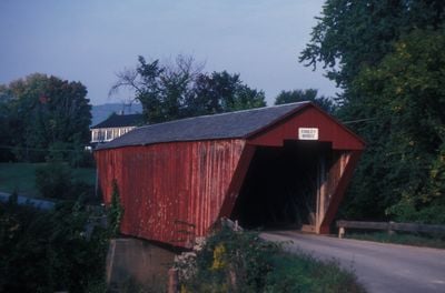
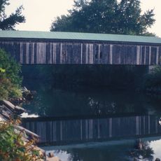
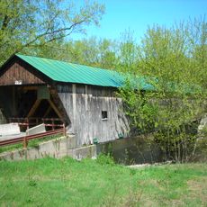
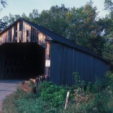
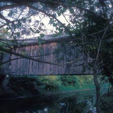
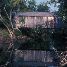
Cooley Covered Bridge, covered bridge in Pittsford, Vermont

The Cooley Covered Bridge is a wooden structure with a roof and enclosed sides that spans a small river in Pittsford, Vermont. Built in 1849 using a Town lattice truss design, the bridge measures about 50 feet (15 meters) long and 18 feet (5.5 meters) wide, with an overhanging roof that extends approximately 16 feet (5 meters) past the sides to shelter the wooden framework from weather.

The bridge was constructed in 1849 by Nicholas M. Powers, a local builder whose innovative methods became influential in regional covered bridge design. His craftsmanship shaped the character of crossings throughout the area, and his legacy endures through structures like this one that remain standing after more than a century and a half.

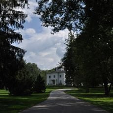
The bridge has served as a local connector for generations, linking parts of Pittsford through shared stories passed down by families. It remains a place where visitors can feel the continuity of community life across time.

The bridge accommodates both pedestrians and vehicles and offers a quiet crossing over the water with minimal traffic. Walk or drive at a leisurely pace to appreciate the wooden structure, and be mindful of the narrow interior space and low clearance typical of covered bridges.

The bridge's slate roof extends about 16 feet past its sides, a particularly generous overhang that shields the wooden frame exceptionally well from the elements. This design feature is rarely seen on older covered bridges and demonstrates Powers' innovative approach to maximizing structural durability and longevity.

The community of curious travelers

AroundUs brings together thousands of curated places, local tips, and hidden gems, enriched daily by 60,000 contributors worldwide.

Start exploring
Location
GPS coordinates
43.69000,-73.02917
Latest update
February 9, 2026 07:41
Around this place
Wilson Castle
United States of America

Wilson Castle

8.5 km
Vermont Marble Museum
United States of America

Vermont Marble Museum

2.9 km
Castleton Medical College Building
United States of America

Castleton Medical College Building

15 km
Paramount Theatre
United States of America

Paramount Theatre

10.2 km
St. Peter's Church and Mount St. Joseph Convent Complex
United States of America

St. Peter's Church and Mount St. Joseph Convent Complex

10.3 km
Thomas H. Palmer House
United States of America

Thomas H. Palmer House

2.1 km
Clementwood
United States of America

Clementwood

10.2 km
Gorham Covered Bridge
United States of America

Gorham Covered Bridge

1.3 km
Marble Bridge
United States of America

Marble Bridge

3.2 km
Hammond Covered Bridge
United States of America

Hammond Covered Bridge

3.9 km
Fort Warren
United States of America

Fort Warren

13.9 km
Linden Terrace
United States of America

Linden Terrace

8.7 km
Rutland Jewish Center
United States of America

Rutland Jewish Center

9.5 km
Sanderson Covered Bridge
United States of America

Sanderson Covered Bridge

12.9 km
Chaffee-Moloney Houses
United States of America

Chaffee-Moloney Houses

9.7 km
Depot Covered Bridge
United States of America

Depot Covered Bridge

2.4 km
Dean Covered Bridge
United States of America

Dean Covered Bridge

11.3 km
Proctor-Clement House
United States of America

Proctor-Clement House

7.8 km
Longfellow School
United States of America

Longfellow School

9.9 km
West Rutland Town Hall
United States of America

West Rutland Town Hall

10.7 km
Colburn Bridge
United States of America

Colburn Bridge

2 km
Watkins School
United States of America

Watkins School

9.6 km
Cold River Bridge
United States of America

Cold River Bridge

14.3 km
Pittsford Green Historic District
United States of America

Pittsford Green Historic District

1.9 km
Rutland Courthouse Historic District
United States of America

Rutland Courthouse Historic District

10.2 km
Arthur Perkins House
United States of America

Arthur Perkins House

12 km
Marble Street Historic District
United States of America

Marble Street Historic District

10.4 km
Wonderfeet Kid's Museum
United States of America

Wonderfeet Kid's Museum

10 km
Show the full map
« Cooley Covered Bridge - covered bridge in Pittsford, Vermont » is provided by Around Us (aroundus.com). Images and texts are derived from Wikimedia project under a Creative Commons license. You are allowed to copy, distribute, and modify copies of this page, under the conditions set by the license, as long as this note is clearly visible.

Discover hidden gems everywhere you go!

From secret cafés to breathtaking viewpoints, skip the crowded tourist spots and find places that match your style. Our app makes it easy with voice search, smart filtering, route optimization, and insider tips from travelers worldwide. Download now for the complete mobile experience.

Around Us App Screenshot

A unique approach to discovering new places

Le Figaro

All the places worth exploring

France Info

A tailor-made excursion in just a few clicks

20 Minutes

Around Us
Travel Guide & Maps
Download

Send to your phone

QR Code
1

Open the camera app on your mobile.

2

Point at the QR code with your camera. A notification will appear.

3

Tap the notification to open the link.