Enable Location

We need your location to show you interesting places around you

Discover nearby places

Find interesting locations and hidden gems around you

Precise directions

Get accurate directions and distances to places

Your location is never shared with other users. It's only used when you tap the location button.

Sam Brown Memorial State Wayside

Log in to your account

Start exploring — it's free

Trusted by 61,910 travelers worldwide

Continue with Google
Continue with Apple
or

We will send you a code to connect

By continuing, you accept our Terms and Conditions and our Privacy Policy

Check your inbox

We've sent a pincode in your inbox. Please enter the code below.

Sam Brown Memorial State Wayside

Sam Brown Memorial State Wayside, Historical state park in Browns Valley, Minnesota, United States.

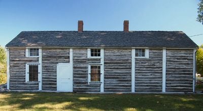
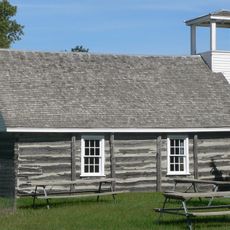
Sam Brown Memorial State Wayside is a small park in Browns Valley featuring a preserved log cabin from the 1860s and outdoor areas for recreation. The one-acre site includes picnic tables and basic visitor facilities set among open grounds.

The log building was constructed in 1864 as part of a military station that served the region's early settlement. The park was established in 1929 to honor Samuel Brown, a local figure who became known for his actions during a crisis.

The log building shows how people lived during the early days of European settlement in Minnesota. Walking through it gives a sense of the conditions and daily life settlers faced in this region.

The park is open year-round with easy walking paths across the grounds accessible to most visitors. Restroom facilities are simple, and the historic cabin can be viewed during warmer months when staff is available.

The cabin was built using a distinctive post-and-plank method that stacked vertical logs in a way different from typical log construction techniques. This building method tells a story about the practical skills and materials available to builders in that era.

The community of curious travelers

AroundUs brings together thousands of curated places, local tips, and hidden gems, enriched daily by 60,000 contributors worldwide.

Start exploring
GPS coordinates
45.59583,-96.84083
Latest update
December 14, 2025 12:21
Around this place
Big Stone Lake
United States of America

Big Stone Lake

27.2 km
International Vinegar Museum
United States of America

International Vinegar Museum

51.9 km
Fort Sisseton
United States of America

Fort Sisseton

54.1 km
Big Stone Lake State Park
United States of America

Big Stone Lake State Park

34.9 km
Big Stone National Wildlife Refuge
United States of America

Big Stone National Wildlife Refuge

55.1 km
Waubay National Wildlife Refuge
United States of America

Waubay National Wildlife Refuge

43.4 km
First Congregational Church of Milbank
United States of America

First Congregational Church of Milbank

44.5 km
Lebanon Lutheran Church
United States of America

Lebanon Lutheran Church

44.4 km
Zoar Norwegian Lutheran Church
United States of America

Zoar Norwegian Lutheran Church

31.6 km
District No. 44 School
United States of America

District No. 44 School

52.5 km
Walla Lutheran Church
United States of America

Walla Lutheran Church

30.3 km
Lars J. Fiksdal House
United States of America

Lars J. Fiksdal House

60.8 km
Browns Valley Carnegie Library
United States of America

Browns Valley Carnegie Library

784 m
Big Stone County Courthouse
United States of America

Big Stone County Courthouse

44.9 km
Palestine Evangelical Lutheran Church
United States of America

Palestine Evangelical Lutheran Church

48.9 km
Brown Earth Presbyterian Church
United States of America

Brown Earth Presbyterian Church

53 km
Roberts County Courthouse
United States of America

Roberts County Courthouse

17.5 km
Andrew and Mary Stavig House
United States of America

Andrew and Mary Stavig House

18 km
Waddel Mansion
United States of America

Waddel Mansion

60.1 km
First National Bank
United States of America

First National Bank

60.5 km
John and Kittie Williams House
United States of America

John and Kittie Williams House

60.4 km
Anton and Mary Agnes Karpen House
United States of America

Anton and Mary Agnes Karpen House

60.5 km
Grant County Courthouse
United States of America

Grant County Courthouse

45.1 km
Sisseton Carnegie Library
United States of America

Sisseton Carnegie Library

17.8 km
Sica Hollow State Park
United States of America

Sica Hollow State Park

34.4 km
Fort Sisseton Historic State Park
United States of America

Fort Sisseton Historic State Park

54.6 km
Nicollet Tower & Interpretive Center
United States of America

Nicollet Tower & Interpretive Center

23.9 km
Graceville Historical Marker
United States of America

Graceville Historical Marker

30.6 km
Show the full map
« Sam Brown Memorial State Wayside - Historical state park in Browns Valley, Minnesota, United States » is provided by Around Us (aroundus.com). Images and texts are derived from Wikimedia project under a Creative Commons license. You are allowed to copy, distribute, and modify copies of this page, under the conditions set by the license, as long as this note is clearly visible.

Discover hidden gems everywhere you go!

From secret cafés to breathtaking viewpoints, skip the crowded tourist spots and find places that match your style. Our app makes it easy with voice search, smart filtering, route optimization, and insider tips from travelers worldwide. Download now for the complete mobile experience.

Around Us App Screenshot

A unique approach to discovering new places

Le Figaro

All the places worth exploring

France Info

A tailor-made excursion in just a few clicks

20 Minutes

Around Us
Travel Guide & Maps
Download

Send to your phone

QR Code
1

Open the camera app on your mobile.

2

Point at the QR code with your camera. A notification will appear.

3

Tap the notification to open the link.