Enable Location

We need your location to show you interesting places around you

Discover nearby places

Find interesting locations and hidden gems around you

Precise directions

Get accurate directions and distances to places

Your location is never shared with other users. It's only used when you tap the location button.

Waubay National Wildlife Refuge

Log in to your account

Start exploring — it's free

Trusted by 62,857 travelers worldwide

Continue with Google
Continue with Apple
or

We will send you a code to connect

By continuing, you accept our Terms and Conditions and our Privacy Policy

Check your inbox

We've sent a pincode in your inbox. Please enter the code below.

Waubay National Wildlife Refuge

Waubay National Wildlife Refuge, National Wildlife Refuge in Day County, South Dakota.

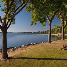
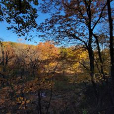
Waubay National Wildlife Refuge is a protected area in Day County covering about 4,650 acres of wetlands, native tallgrass prairie, and bur oak forest. These varied habitats support more than 240 bird species that reside or pass through throughout the year.

The refuge was established in 1935 by the U.S. Fish and Wildlife Service to protect migratory birds. Its creation was part of a broader effort to preserve the natural diversity of the Prairie Pothole Region.

The name comes from the Dakota word 'wabe', meaning a place where many birds build their nests. You can observe these nesting areas, particularly during breeding season when activity peaks around the shallow waters and grasslands.

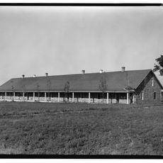
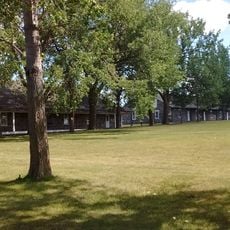
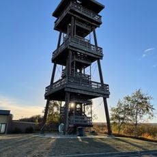
The refuge is open during daylight hours and offers a 1.5-mile hiking trail from the headquarters area and a 110-foot observation tower for wildlife viewing. An information center provides guidance and helps visitors understand what to look for throughout the property.

The refuge sits at a crossroads where animal and plant species from different geographic regions meet and overlap. This unusual location allows visitors to observe species that typically inhabit separate ecosystems existing together in one place.

The community of curious travelers

AroundUs brings together thousands of curated places, local tips, and hidden gems, enriched daily by 60,000 contributors worldwide.

Start exploring
Location
Inception
1935
GPS coordinates
45.42490,-97.34090
Latest update
December 14, 2025 13:02
Around this place
Big Stone Lake
United States of America

Big Stone Lake

56.5 km
International Vinegar Museum
United States of America

International Vinegar Museum

14.2 km
Fort Sisseton
United States of America

Fort Sisseton

29.8 km
Bramble Park Zoo
United States of America

Bramble Park Zoo

59.9 km
Sam Brown Memorial State Wayside
United States of America

Sam Brown Memorial State Wayside

43.4 km
Watertown Stadium
United States of America

Watertown Stadium

60.1 km
Augustana Swedish Lutheran Church
United States of America

Augustana Swedish Lutheran Church

55.1 km
Lebanon Lutheran Church
United States of America

Lebanon Lutheran Church

22.6 km
Zoar Norwegian Lutheran Church
United States of America

Zoar Norwegian Lutheran Church

15.4 km
Lars J. Fiksdal House
United States of America

Lars J. Fiksdal House

17.6 km
Browns Valley Carnegie Library
United States of America

Browns Valley Carnegie Library

44.1 km
Palestine Evangelical Lutheran Church
United States of America

Palestine Evangelical Lutheran Church

55.6 km
Brown Earth Presbyterian Church
United States of America

Brown Earth Presbyterian Church

55.9 km
Roberts County Courthouse
United States of America

Roberts County Courthouse

35.2 km
Andrew and Mary Stavig House
United States of America

Andrew and Mary Stavig House

34.6 km
Marshall County Courthouse
United States of America

Marshall County Courthouse

52.1 km
Waddel Mansion
United States of America

Waddel Mansion

17 km
First National Bank
United States of America

First National Bank

17.3 km
John and Kittie Williams House
United States of America

John and Kittie Williams House

17.1 km
First Presbyterian Church of Langford
United States of America

First Presbyterian Church of Langford

43.1 km
William Havens House
United States of America

William Havens House

17.7 km
Anton and Mary Agnes Karpen House
United States of America

Anton and Mary Agnes Karpen House

17.2 km
Grant County Courthouse
United States of America

Grant County Courthouse

59.8 km
Sisseton Carnegie Library
United States of America

Sisseton Carnegie Library

35.2 km
Sica Hollow State Park
United States of America

Sica Hollow State Park

36.5 km
Fort Sisseton Historic State Park
United States of America

Fort Sisseton Historic State Park

30 km
Nicollet Tower & Interpretive Center
United States of America

Nicollet Tower & Interpretive Center

30.7 km
West Pickerel Lake Recreation Area
United States of America

West Pickerel Lake Recreation Area

9.8 km
Show the full map
« Waubay National Wildlife Refuge - National Wildlife Refuge in Day County, South Dakota » is provided by Around Us (aroundus.com). Images and texts are derived from Wikimedia project under a Creative Commons license. You are allowed to copy, distribute, and modify copies of this page, under the conditions set by the license, as long as this note is clearly visible.

Discover hidden gems everywhere you go!

From secret cafés to breathtaking viewpoints, skip the crowded tourist spots and find places that match your style. Our app makes it easy with voice search, smart filtering, route optimization, and insider tips from travelers worldwide. Download now for the complete mobile experience.

Around Us App Screenshot

A unique approach to discovering new places

Le Figaro

All the places worth exploring

France Info

A tailor-made excursion in just a few clicks

20 Minutes

Around Us
Travel Guide & Maps
Download

Send to your phone

QR Code
1

Open the camera app on your mobile.

2

Point at the QR code with your camera. A notification will appear.

3

Tap the notification to open the link.