·

Enable Location

We need your location to show you interesting places around you

Discover nearby places

Find interesting locations and hidden gems around you

Precise directions

Get accurate directions and distances to places

Your location is never shared with other users. It's only used when you tap the location button.

Culver Union Hospital

Log in to your account

Start exploring — it's free

Trusted by 62,647 travelers worldwide

Continue with Google
Continue with Apple
or

We will send you a code to connect

By continuing, you accept our Terms and Conditions and our Privacy Policy

Check your inbox

We've sent a pincode in your inbox. Please enter the code below.

Culver Union Hospital, hospital in Indiana, United States

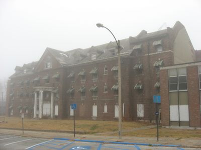
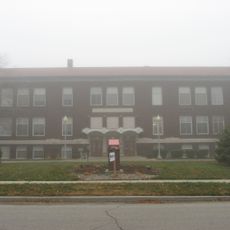
Culver Union Hospital is a four-story brick building in Colonial Revival style with Ionic columns at the entrance and a pitched roof. Built in 1902 and expanded multiple times through 1977, it was converted in 2016 into Historic Whitlock Place, offering studios and one- to two-bedroom apartments for residents.

The hospital was founded in 1902 with support from L.L. Culver and served Montgomery County as the main healthcare facility with all local doctors on staff. After financial struggles, it closed in 1984 and was fully vacated in 1997, then recognized on the National Register of Historic Places in 2001.

The building reflects the role women and local communities played in establishing healthcare in the area. Its transformation into apartments shows how historic structures serve new purposes while maintaining their connection to the past.

The building now houses senior apartments in various sizes including studios and one- to two-bedroom units. The location is walkable with nearby shops and restaurants, and amenities like elevators and 24-hour maintenance support residents throughout the property.

The hospital was started by women in Montgomery County in the late 1800s who raised funds and worked with doctors to create healthcare for their community. This founding story makes it a notable example of women's civic participation in rural America during that era.

The community of curious travelers

AroundUs brings together thousands of curated places, local tips, and hidden gems, enriched daily by 60,000 contributors worldwide.

Start exploring
Location
GPS coordinates
40.04444,-86.89667
Latest update
February 9, 2026 08:20
Around this place
Shades State Park
United States of America

Shades State Park

20.2 km
General Lew Wallace Study
United States of America

General Lew Wallace Study

472 m
Ropkey Armor Museum
United States of America

Ropkey Armor Museum

8.7 km
Montgomery County Jail and Sheriff's Residence
United States of America

Montgomery County Jail and Sheriff's Residence

431 m
Crawfordsville Senior High School
United States of America

Crawfordsville Senior High School

816 m
Portland Mills Covered Bridge
United States of America

Portland Mills Covered Bridge

26.2 km
Henry S. Lane House
United States of America

Henry S. Lane House

497 m
Col. Isaac C. Elston House
United States of America

Col. Isaac C. Elston House

472 m
Darlington Covered Bridge
United States of America

Darlington Covered Bridge

11.3 km
George Seybold House
United States of America

George Seybold House

22.6 km
Bethel AME Church of Crawfordsville
United States of America

Bethel AME Church of Crawfordsville

616 m
Thorntown Public Library
United States of America

Thorntown Public Library

26.5 km
T.C. Steele Boyhood Home
United States of America

T.C. Steele Boyhood Home

22.6 km
Saint John's Episcopal Church
United States of America

Saint John's Episcopal Church

521 m
McClelland-Layne House
United States of America

McClelland-Layne House

1.1 km
Normal Hall
United States of America

Normal Hall

16.5 km
Elston Grove Historic District
United States of America

Elston Grove Historic District

509 m
Crawfordsville Commercial Historic District
United States of America

Crawfordsville Commercial Historic District

3.1 km
Ashby
United States of America

Ashby

16.8 km
Samuel Brown House
United States of America

Samuel Brown House

25.8 km
Abijah O'Neall II House
United States of America

Abijah O'Neall II House

7.8 km
Colfax Carnegie Library
United States of America

Colfax Carnegie Library

25.7 km
Milligan Park Pool and Splash Pad
United States of America

Milligan Park Pool and Splash Pad

2.1 km
William Fisher Polygonal Barn
United States of America

William Fisher Polygonal Barn

18.1 km
Linden Depot
United States of America

Linden Depot

16.6 km
Linden Depot Museum
United States of America

Linden Depot Museum

16.5 km
Cornstalk Covered Bridge
United States of America

Cornstalk Covered Bridge

20.3 km
Deer's Mill Covered Bridge
United States of America

Deer's Mill Covered Bridge

17.7 km
Show the full map
« Culver Union Hospital - hospital in Indiana, United States » is provided by Around Us (aroundus.com). Images and texts are derived from Wikimedia project under a Creative Commons license. You are allowed to copy, distribute, and modify copies of this page, under the conditions set by the license, as long as this note is clearly visible.

Discover hidden gems everywhere you go!

From secret cafés to breathtaking viewpoints, skip the crowded tourist spots and find places that match your style. Our app makes it easy with voice search, smart filtering, route optimization, and insider tips from travelers worldwide. Download now for the complete mobile experience.

Around Us App Screenshot

A unique approach to discovering new places

Le Figaro

All the places worth exploring

France Info

A tailor-made excursion in just a few clicks

20 Minutes

Around Us
Travel Guide & Maps
Download

Send to your phone

QR Code
1

Open the camera app on your mobile.

2

Point at the QR code with your camera. A notification will appear.

3

Tap the notification to open the link.