Hunting Camp Creek Wilderness

Log in to your account

AroundUs is a community-driven map of interesting places, built by curious explorers like you. It grows with every review, story, and photo you share.
Connect to save your favorite spots, contribute locations, and create personalized routes.
By continuing, you accept our Terms and Conditions and our Privacy Policy

Hunting Camp Creek Wilderness

Add to collection
Map
Suggest a change
Share

Hunting Camp Creek Wilderness, Protected wilderness area in Bland County, Virginia, United States

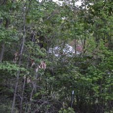
Hunting Camp Creek Wilderness is a protected forest zone in the George Washington and Jefferson National Forests, featuring steep mountain ridges, dense deciduous woodlands, and numerous streams throughout the landscape. The terrain supports diverse plant and animal communities in a remote, undeveloped setting.

The wilderness was designated through Congressional action via the Eastern Wilderness Act to protect it from development and preserve its natural condition. This legislation recognized the importance of safeguarding undeveloped forest land in the region.

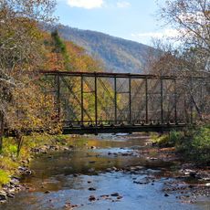
The Appalachian National Scenic Trail extends 7.5 miles through the wilderness, offering connections to the broader Appalachian mountain heritage.

Access is available through trailheads located along Virginia Routes 615 and 623, with maps essential for navigation in this remote location. Visitors should prepare for challenging terrain featuring steep slopes and wet stream areas.

Multiple beaver ponds in upper Hunting Camp Creek create wetland areas where uncommon plants such as cinnamon ferns and red catchfly thrive naturally. These ecosystems enrich the biological diversity throughout the wilderness.

GPS coordinates: 37.08795,-81.24977

Latest update: December 14, 2025 18:08

Photos
Around this place
Big Walker Lookout
United States of America

Big Walker Lookout

5.1 km
Pinnacle Rock State Park
United States of America

Pinnacle Rock State Park

26.3 km
Mountain Glen
United States of America

Mountain Glen

11.8 km
Walker Mountain Cluster
United States of America

Walker Mountain Cluster

12 km
Wytheville Historic District
United States of America

Wytheville Historic District

21.7 km
Beartown Wilderness
United States of America

Beartown Wilderness

17.3 km
Walter McDonald Sanders House
United States of America

Walter McDonald Sanders House

16.8 km
Hancock House
United States of America

Hancock House

21.1 km
Loretto
United States of America

Loretto

20.9 km
Wolf Creek Bridge
United States of America

Wolf Creek Bridge

21.6 km
Crockett's Cove Presbyterian Church
United States of America

Crockett's Cove Presbyterian Church

20.1 km
James Wynn House
United States of America

James Wynn House

24.1 km
Wythe County Poorhouse Farm
United States of America

Wythe County Poorhouse Farm

23 km
Bramwell Historic District
United States of America

Bramwell Historic District

26.8 km
Sharon Lutheran Church and Cemetery
United States of America

Sharon Lutheran Church and Cemetery

12 km
Alexander St. Clair House
United States of America

Alexander St. Clair House

17.1 km
Kimberling Lutheran Cemetery
United States of America

Kimberling Lutheran Cemetery

19.6 km
Reed Creek Mill
United States of America

Reed Creek Mill

23 km
Tazewell Historic District
United States of America

Tazewell Historic District

24.3 km
Haller-Gibboney Rock House
United States of America

Haller-Gibboney Rock House

21.2 km
Capt. James Moore Homestead
United States of America

Capt. James Moore Homestead

23.8 km
South Bluefield Historic District
United States of America

South Bluefield Historic District

19.2 km
Bramwell Additions Historic District
United States of America

Bramwell Additions Historic District

26.8 km
Pocahontas Historic District
United States of America

Pocahontas Historic District

25.8 km
Easley House
United States of America

Easley House

18.1 km
Junius Marcellus Updyke Farm
United States of America

Junius Marcellus Updyke Farm

19.7 km
Clynchdale
United States of America

Clynchdale

20 km
Mountaineer Bowling Lanes
United States of America

Mountaineer Bowling Lanes

19.4 km
Show the full map
Reviews

Visited this place? Tap the stars to rate it and share your experience / photos with the community! Try now! You can cancel it anytime.

« Hunting Camp Creek Wilderness - Protected wilderness area in Bland County, Virginia, United States » is provided by Around Us (aroundus.com). Images and texts are derived from Wikimedia project under a Creative Commons license. You are allowed to copy, distribute, and modify copies of this page, under the conditions set by the license, as long as this note is clearly visible.

Discover hidden gems everywhere you go!

From secret cafés to breathtaking viewpoints, skip the crowded tourist spots and find places that match your style. Our app makes it easy with voice search, smart filtering, route optimization, and insider tips from travelers worldwide. Download now for the complete mobile experience.

Around Us App Screenshot

A unique approach to discovering new places

Le Figaro

All the places worth exploring

France Info

A tailor-made excursion in just a few clicks

20 Minutes