Enable Location

We need your location to show you interesting places around you

Discover nearby places

Find interesting locations and hidden gems around you

Precise directions

Get accurate directions and distances to places

Your location is never shared with other users. It's only used when you tap the location button.

Indian Stones

Log in to your account

Start exploring — it's free

Trusted by 61,937 travelers worldwide

Continue with Google
Continue with Apple
or

We will send you a code to connect

By continuing, you accept our Terms and Conditions and our Privacy Policy

Check your inbox

We've sent a pincode in your inbox. Please enter the code below.

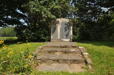
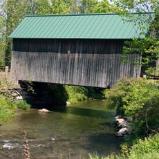
Indian Stones, Historic memorial stones in Reading, Vermont

Indian Stones are memorial markers carved into granite located along Route 106 in Reading, Vermont. The stones sit directly beside the state highway with informational plaques nearby to explain what they commemorate.

Elizabeth Captive Johnson commissioned these stones in 1799 to mark where she was born during captivity with Native American tribes. The site reflects a turning point in how European settlers remembered their encounters with indigenous peoples.

The stones mark a meeting point between the Abenaki people and European settlers during early colonial times. Visitors today can trace the connections between these two worlds through the carved markers.

The stones sit right along State Highway 106 and are easy to reach from the road. Early morning or late afternoon visits work well when traffic is lighter and the light better shows the carved details.

These rank among Vermont's oldest memorial markers, recording an unusual birth story that might otherwise have been forgotten. They show how early settlers preserved personal memories in stone long before organized historical preservation became common.

The community of curious travelers

AroundUs brings together thousands of curated places, local tips, and hidden gems, enriched daily by 60,000 contributors worldwide.

Start exploring
Location
GPS coordinates
43.44639,-72.53528
Latest update
December 14, 2025 18:09
Around this place
Juniper Hill Farm-Maxwell Evarts House
United States of America

Juniper Hill Farm-Maxwell Evarts House

12.4 km
Cornish–Windsor Covered Bridge
United States of America

Cornish–Windsor Covered Bridge

12.6 km
Mount Ascutney
United States of America

Mount Ascutney

6.5 km
American Precision Museum
United States of America

American Precision Museum

12.2 km
Jenne Farm
United States of America

Jenne Farm

8.9 km
Ascutney Mill Dam
United States of America

Ascutney Mill Dam

11.7 km
Salmon P. Chase Birthplace
United States of America

Salmon P. Chase Birthplace

12 km
Cornish Colony Museum
United States of America

Cornish Colony Museum

12.5 km
Ascutney State Park
United States of America

Ascutney State Park

7.8 km
Glimmerstone
United States of America

Glimmerstone

9.5 km
Brook Farm
United States of America

Brook Farm

9.7 km
Windsor Village Historic District
United States of America

Windsor Village Historic District

12.6 km
Bowers Covered Bridge
United States of America

Bowers Covered Bridge

3.9 km
Best's Covered Bridge
United States of America

Best's Covered Bridge

1.8 km
Upper Falls Covered Bridge
United States of America

Upper Falls Covered Bridge

5.4 km
Windsor House
United States of America

Windsor House

12.7 km
Iron Bridge at Howard Hill Road
United States of America

Iron Bridge at Howard Hill Road

5.7 km
Aaron Jr. and Susan Parker Farm
United States of America

Aaron Jr. and Susan Parker Farm

6.7 km
Fowler-Steele House
United States of America

Fowler-Steele House

13 km
Pollard Block
United States of America

Pollard Block

11 km
South Reading Schoolhouse
United States of America

South Reading Schoolhouse

5.8 km
NAMCO Block
United States of America

NAMCO Block

12.2 km
Weathersfield Center Historic District
United States of America

Weathersfield Center Historic District

9.3 km
Lockwood-Boynton House
United States of America

Lockwood-Boynton House

12.6 km
Spaulding Bridge
United States of America

Spaulding Bridge

9.3 km
Reading Town Hall
United States of America

Reading Town Hall

1 km
Twing Buckman House
United States of America

Twing Buckman House

12 km
Old Constitution House
United States of America

Old Constitution House

12.8 km
Show the full map
« Indian Stones - Historic memorial stones in Reading, Vermont » is provided by Around Us (aroundus.com). Images and texts are derived from Wikimedia project under a Creative Commons license. You are allowed to copy, distribute, and modify copies of this page, under the conditions set by the license, as long as this note is clearly visible.

Discover hidden gems everywhere you go!

From secret cafés to breathtaking viewpoints, skip the crowded tourist spots and find places that match your style. Our app makes it easy with voice search, smart filtering, route optimization, and insider tips from travelers worldwide. Download now for the complete mobile experience.

Around Us App Screenshot

A unique approach to discovering new places

Le Figaro

All the places worth exploring

France Info

A tailor-made excursion in just a few clicks

20 Minutes

Around Us
Travel Guide & Maps
Download

Send to your phone

QR Code
1

Open the camera app on your mobile.

2

Point at the QR code with your camera. A notification will appear.

3

Tap the notification to open the link.