Chest opened
+${chestReward.xp} XP
Explorer
NOUVEAU ×${chestReward.collectible.quantity}
tapez pour fermer
Chest locked

Open chests in the app

Around Us is built for your phone — chests unlock when you walk, explore and capture nearby places.

Enable Location

We need your location to show you interesting places around you

Discover nearby places

Find interesting locations and hidden gems around you

Precise directions

Get accurate directions and distances to places

Your location is never shared with other users. It's only used when you tap the location button.

Log in to your account

Start exploring — it's free

Trusted by 72,903 travelers worldwide

Continue with Google
Continue with Apple
or

We will send you a code to connect

By continuing, you accept our Terms and Conditions and our Privacy Policy

Check your inbox

We've sent a pincode in your inbox. Please enter the code below.

Backcountry
Discussion Reviews Photo
11.1k Popularity

Backcountry, Remote hiking destination in Monongahela National Forest, West Virginia.

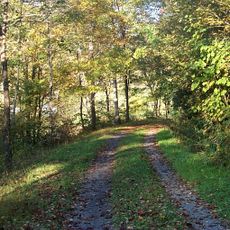
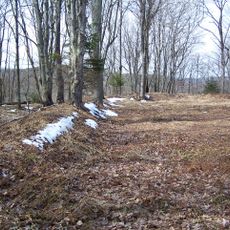
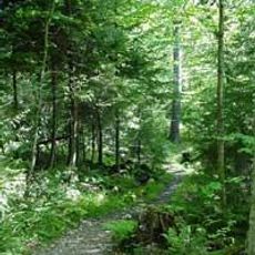
Backcountry is a remote wilderness area in Monongahela National Forest characterized by steep mountains, dense forest, flowing streams, and diverse wildlife throughout. The land remains largely undeveloped with few or no established services for visitors.

Extensive logging devastated the region until Monongahela National Forest was established in 1920 to protect what remained of the natural landscape. The forest has since recovered and grown back to become the wilderness it is today.

Local people have deep roots in outdoor traditions, and visitors can witness practices like foraging and hunting that remain part of daily life here. These activities shape how the community interacts with the land and its resources.

Visitors should bring detailed maps and GPS devices since the area is very remote with few marked trails and no cell phone coverage. Planning carefully is essential before heading out, as help can be far away.

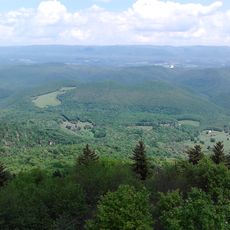
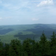
The North Fork Mountain Trail offers long ridge walks with views across multiple valleys and passes near rock formations dating back hundreds of millions of years. These geological features show the ancient processes that shaped the mountains.

The community of curious travelers

AroundUs brings together thousands of curated places, local tips, and hidden gems, enriched daily by 60,000 contributors worldwide.

Start exploring
Location
GPS coordinates
38.43850,-79.95920
Latest update
December 8, 2025 13:42
Around this place
Green Bank Telescope
United States of America

Green Bank Telescope

10.4 km
Cass Scenic Railroad State Park
United States of America

Cass Scenic Railroad State Park

6.1 km
Durbin and Greenbrier Valley Railroad
United States of America

Durbin and Greenbrier Valley Railroad

16.2 km
Greenbrier River Trail
United States of America

Greenbrier River Trail

26.9 km
Bald Knob
United States of America

Bald Knob

2.7 km
Green Bank Interferometer
United States of America

Green Bank Interferometer

10.5 km
White Top
United States of America

White Top

21.9 km
Gaudineer Scenic Area
United States of America

Gaudineer Scenic Area

23.4 km
Gaudineer Knob
United States of America

Gaudineer Knob

22.1 km
Reber Radio Telescope
United States of America

Reber Radio Telescope

12.4 km
40-foot telescope
United States of America

40-foot telescope

11.1 km
Monterey Hotel
United States of America

Monterey Hotel

33.1 km
Seneca State Forest
United States of America

Seneca State Forest

12.5 km
Shavers Fork Mountain Complex
United States of America

Shavers Fork Mountain Complex

22.1 km
Monterey High School
United States of America

Monterey High School

32.6 km
Camp Bartow Historic District
United States of America

Camp Bartow Historic District

19.8 km
Pocahontas County Opera House
United States of America

Pocahontas County Opera House

26.8 km
E. E. Hutton House
United States of America

E. E. Hutton House

30.9 km
Frank and Anna Hunter House
United States of America

Frank and Anna Hunter House

27.2 km
Pocahontas County Courthouse and Jail
United States of America

Pocahontas County Courthouse and Jail

27 km
Cass Historic District
United States of America

Cass Historic District

6.3 km
C.P. Jones House and Law Office
United States of America

C.P. Jones House and Law Office

33 km
IOOF Lodge Building
United States of America

IOOF Lodge Building

26.7 km
Green Bank Observatory
United States of America

Green Bank Observatory

10.7 km
Green Bank Observatory Science Center
United States of America

Green Bank Observatory Science Center

12.4 km
300 foot Radio Telescope
United States of America

300 foot Radio Telescope

10.4 km
Green Bank Jansky Antenna
United States of America

Green Bank Jansky Antenna

12.5 km
Howard E. Tatel Radio Telescope
United States of America

Howard E. Tatel Radio Telescope

11.4 km
Show the full map
Reviews
Share your experience

No review yet

Discussions
Start a discussion...

No discussion yet

« Backcountry - Remote hiking destination in Monongahela National Forest, West Virginia » is provided by Around Us (aroundus.com). Images and texts are derived from Wikimedia project under a Creative Commons license. You are allowed to copy, distribute, and modify copies of this page, under the conditions set by the license, as long as this note is clearly visible.

Discover hidden gems everywhere you go!

From secret cafés to breathtaking viewpoints, skip the crowded tourist spots and find places that match your style. Our app makes it easy with voice search, smart filtering, route optimization, and insider tips from travelers worldwide. Download now for the complete mobile experience.

Around Us App Screenshot

A unique approach to discovering new places

Le Figaro

All the places worth exploring

France Info

A tailor-made excursion in just a few clicks

20 Minutes

Around Us
Travel Guide & Maps
Download

Send to your phone

QR Code
1

Open the camera app on your mobile.

2

Point at the QR code with your camera. A notification will appear.

3

Tap the notification to open the link.