Enable Location

We need your location to show you interesting places around you

Discover nearby places

Find interesting locations and hidden gems around you

Precise directions

Get accurate directions and distances to places

Your location is never shared with other users. It's only used when you tap the location button.

Gaudineer Knob

Log in to your account

Start exploring — it's free

Trusted by 61,515 travelers worldwide

Continue with Google
Continue with Apple
or

We will send you a code to connect

By continuing, you accept our Terms and Conditions and our Privacy Policy

Check your inbox

We've sent a pincode in your inbox. Please enter the code below.

Gaudineer Knob

Gaudineer Knob, Mountain summit in Randolph County, United States.

Description

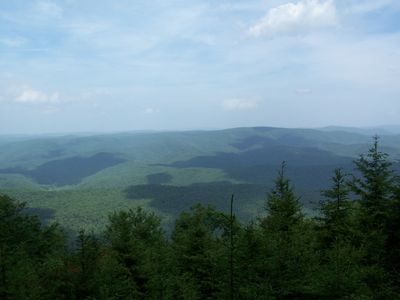
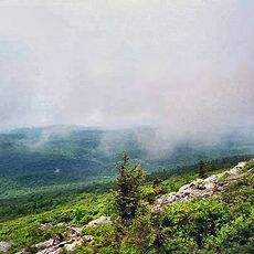
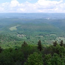
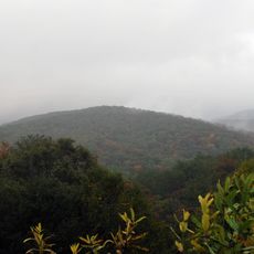
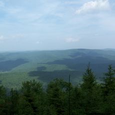
Gaudineer Knob is a mountain summit in the Allegheny Mountains that reaches about 4,460 feet in elevation. The peak sits covered in a vast red spruce forest that dominates the highest point of Shavers Mountain throughout the area.

History

A surveying mistake in the 1860s accidentally protected roughly 50 acres of red spruce forest from the logging boom of later decades. This error became fortunate, preserving the forest while surrounding areas faced heavy timber removal between 1890 and 1920.

Culture

The summit bears the name of Donald Gaudineer, a forest ranger whose memory was honored here starting in 1930 after a tragic loss. This naming connects the place to a personal story of sacrifice that shaped how people remember this mountain today.

Practical

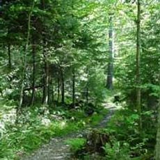
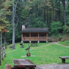
Forest Service Road 27A provides vehicle access to a summit parking area equipped with basic facilities like toilets and picnic tables. Several hiking trails depart from this location, offering routes of varying difficulty through the surrounding forest.

Did you know?

The individual red spruce trees here grow to diameters around one meter and some have lived for roughly 3 centuries. These ancient specimens have become quite rare in this region, making the forest here a remarkable sight to encounter.

Location
GPS coordinates
38.61539,-79.84423
Latest update
December 12, 2025 14:24

AroundUs brings together thousands of curated places, local tips, and hidden gems, enriched daily by 60,000 contributors worldwide. Discover all places nearby (West Virginia).

Around this place
Green Bank Telescope
United States of America

Green Bank Telescope

20.3 km
Spruce Knob
United States of America

Spruce Knob

28.7 km
Cass Scenic Railroad State Park
United States of America

Cass Scenic Railroad State Park

25.1 km
Durbin and Greenbrier Valley Railroad
United States of America

Durbin and Greenbrier Valley Railroad

7.9 km
Bald Knob
United States of America

Bald Knob

20.1 km
Green Bank Interferometer
United States of America

Green Bank Interferometer

20.3 km
White Top
United States of America

White Top

3 km
Gaudineer Scenic Area
United States of America

Gaudineer Scenic Area

1.4 km
Reber Radio Telescope
United States of America

Reber Radio Telescope

20.7 km
40-foot telescope
United States of America

40-foot telescope

19.9 km
Laurel Fork North Wilderness
United States of America

Laurel Fork North Wilderness

21.7 km
Middle Mountain Cabins
United States of America

Middle Mountain Cabins

12.5 km
Tygart Valley Homesteads Historic District
United States of America

Tygart Valley Homesteads Historic District

18.8 km
Laurel Fork South Wilderness
United States of America

Laurel Fork South Wilderness

15.3 km
Shavers Fork Mountain Complex
United States of America

Shavers Fork Mountain Complex

10 m
Camp Bartow Historic District
United States of America

Camp Bartow Historic District

11.2 km
E. E. Hutton House
United States of America

E. E. Hutton House

16.2 km
Cass Historic District
United States of America

Cass Historic District

25.8 km
Beverly Historic District
United States of America

Beverly Historic District

25.3 km
Butcher Hill Historic District
United States of America

Butcher Hill Historic District

25.5 km
Blackman-Bosworth Store
United States of America

Blackman-Bosworth Store

25.3 km
Green Bank Observatory
United States of America

Green Bank Observatory

19.8 km
Green Bank Observatory Science Center
United States of America

Green Bank Observatory Science Center

20.8 km
300 foot Radio Telescope
United States of America

300 foot Radio Telescope

20.3 km
Green Bank Jansky Antenna
United States of America

Green Bank Jansky Antenna

20.6 km
Beverly Heritage Center
United States of America

Beverly Heritage Center

25.2 km
Howard E. Tatel Radio Telescope
United States of America

Howard E. Tatel Radio Telescope

20 km
Green Bank 85-3 telescope
United States of America

Green Bank 85-3 telescope

20.7 km
Show the full map
« Gaudineer Knob - Mountain summit in Randolph County, United States » is provided by Around Us (aroundus.com). Images and texts are derived from Wikimedia project under a Creative Commons license. You are allowed to copy, distribute, and modify copies of this page, under the conditions set by the license, as long as this note is clearly visible.

Discover hidden gems everywhere you go!

From secret cafés to breathtaking viewpoints, skip the crowded tourist spots and find places that match your style. Our app makes it easy with voice search, smart filtering, route optimization, and insider tips from travelers worldwide. Download now for the complete mobile experience.

Around Us App Screenshot

A unique approach to discovering new places

Le Figaro

All the places worth exploring

France Info

A tailor-made excursion in just a few clicks

20 Minutes

Around Us
Travel Guide & Maps
Download

Send to your phone

QR Code
1

Open the camera app on your mobile.

2

Point at the QR code with your camera. A notification will appear.

3

Tap the notification to open the link.