Enable Location

We need your location to show you interesting places around you

Discover nearby places

Find interesting locations and hidden gems around you

Precise directions

Get accurate directions and distances to places

Your location is never shared with other users. It's only used when you tap the location button.

Foss Peak

Log in to your account

Start exploring — it's free

Trusted by 61,668 travelers worldwide

Continue with Google
Continue with Apple
or

We will send you a code to connect

By continuing, you accept our Terms and Conditions and our Privacy Policy

Check your inbox

We've sent a pincode in your inbox. Please enter the code below.

Foss Peak

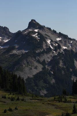
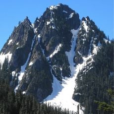
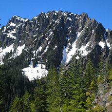
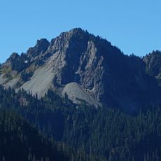
Foss Peak, Mountain summit in Mount Rainier National Park, United States

Description

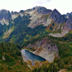
Foss Peak is a summit in the Tatoosh Range located south of Mount Rainier within the national park boundaries. The peak sits at approximately 6,500 feet and connects to other peaks in this mountain chain that draw climbers and hikers throughout the year.

History

The summit was named after Thea Foss, a businesswoman who was active in Washington state during the early 1900s. The peak has been a recognized climbing destination in this mountain range for many decades.

Culture

The peak forms part of several mountaineering challenges, including the Mount Rainier 100 Peaks Pin program organized by the Mountaineers Club.

Practical

The best time to climb is from June through September when snow coverage is minimal and conditions are safest. Routes require proper gear and fitness levels, so visitors should prepare accordingly before attempting the ascent.

Did you know?

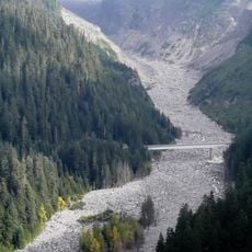
The peak is also known locally by the name Manatee Mountain, an alternative designation rarely used in climbing communities. Water draining from the summit flows into tributaries that feed the Cowlitz River system.

GPS coordinates
46.75522,-121.71271
Latest update
December 14, 2025 20:01

AroundUs brings together thousands of curated places, local tips, and hidden gems, enriched daily by 60,000 contributors worldwide. Discover all places nearby (United States of America).

Around this place
Paradise Inn
United States of America

Paradise Inn

3.9 km
Narada Falls
United States of America

Narada Falls

3.4 km
Henry M. Jackson Visitor Center
United States of America

Henry M. Jackson Visitor Center

3.9 km
Christine Falls
United States of America

Christine Falls

5.9 km
Paradise Historic District
United States of America

Paradise Historic District

3.8 km
Christine Falls Bridge
United States of America

Christine Falls Bridge

5.8 km
Narada Falls Bridge
United States of America

Narada Falls Bridge

3.4 km
Plummer Peak
United States of America

Plummer Peak

2.1 km
Edith Creek Chlorination House
United States of America

Edith Creek Chlorination House

4.6 km
Lane Peak
United States of America

Lane Peak

3.1 km
Narada Falls Comfort Station
United States of America

Narada Falls Comfort Station

3.4 km
Eagle Peak
United States of America

Eagle Peak

5.1 km
Pinnacle Peak
United States of America

Pinnacle Peak

1.5 km
Chutla Peak
United States of America

Chutla Peak

4.7 km
Denman Peak
United States of America

Denman Peak

2.4 km
Wahpenayo Peak
United States of America

Wahpenayo Peak

4.2 km
Mount Rainier National Historic Landmark District
United States of America

Mount Rainier National Historic Landmark District

3.9 km
Stevens Canyon Tunnel
United States of America

Stevens Canyon Tunnel

3.9 km
Myrtle Falls
United States of America

Myrtle Falls

4.3 km
Stevens Creek Bridge
United States of America

Stevens Creek Bridge

2.4 km
Edith Creek Bridge
United States of America

Edith Creek Bridge

4.1 km
Paradise Ranger Station
United States of America

Paradise Ranger Station

3.9 km
Paradise Climbing Information Center
United States of America

Paradise Climbing Information Center

3.9 km
Paradise River Fourth Crossing Bridge
United States of America

Paradise River Fourth Crossing Bridge

4 km
Cougar Rock Campground
United States of America

Cougar Rock Campground

6.4 km
Inspiration Point
United States of America

Inspiration Point

3.2 km
Stevens-Van Trump Historical Monument
United States of America

Stevens-Van Trump Historical Monument

4.3 km
Nisqually Glacier Bridge
United States of America

Nisqually Glacier Bridge

4.8 km
Show the full map
« Foss Peak - Mountain summit in Mount Rainier National Park, United States » is provided by Around Us (aroundus.com). Images and texts are derived from Wikimedia project under a Creative Commons license. You are allowed to copy, distribute, and modify copies of this page, under the conditions set by the license, as long as this note is clearly visible.

Discover hidden gems everywhere you go!

From secret cafés to breathtaking viewpoints, skip the crowded tourist spots and find places that match your style. Our app makes it easy with voice search, smart filtering, route optimization, and insider tips from travelers worldwide. Download now for the complete mobile experience.

Around Us App Screenshot

A unique approach to discovering new places

Le Figaro

All the places worth exploring

France Info

A tailor-made excursion in just a few clicks

20 Minutes

Around Us
Travel Guide & Maps
Download

Send to your phone

QR Code
1

Open the camera app on your mobile.

2

Point at the QR code with your camera. A notification will appear.

3

Tap the notification to open the link.