Enable Location

We need your location to show you interesting places around you

Discover nearby places

Find interesting locations and hidden gems around you

Precise directions

Get accurate directions and distances to places

Your location is never shared with other users. It's only used when you tap the location button.

Chutla Peak

Log in to your account

Save your favorite places
Create custom travel routes
Rate and review places
Access the full interactive map
Continue with Google
Continue with Apple
Continue with email
By continuing, you accept our Terms and Conditions and our Privacy Policy
Create an account
Add to collection
Map
Suggest a change
Share

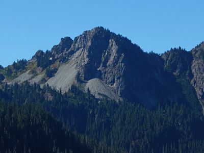
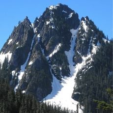
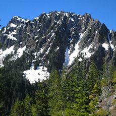
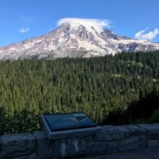
Chutla Peak, Mountain summit in Lewis County, Washington, US.

Chutla Peak is a mountain summit in the Tatoosh Range, part of the Cascade Mountains within Mount Rainier National Park. The peak rises to approximately 1830 meters (6000 feet) and stands as a distinct point along this ridge system.

The name comes from Chinook Jargon, where 'Chutla' means rock. This name choice reflects the stone and rocky character of the summit.

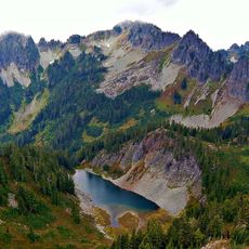
The peak contributes to the water system of the region as precipitation from its slopes flows into the Nisqually River.

Reaching the summit requires hiking the Eagle Peak Trail and traversing the northwest ridge to the top. The best climbing season runs from July through October when snow and ice are less of an obstacle.

The peak sits along a watershed where rainfall flows into the Nisqually River, shaping the region's water cycle. This hydrological role gives it a function beyond being merely a geographic marker.

Location: Washington

Location: Lewis County

Elevation above the sea: 1,831 m

GPS coordinates: 46.75261,-121.77482

Latest update: December 14, 2025 20:29

Photos
Around this place
Christine Falls
United States of America

Christine Falls

3.2 km
Christine Falls Bridge
United States of America

Christine Falls Bridge

3.2 km
Longmire Buildings
United States of America

Longmire Buildings

2.8 km
Plummer Peak
United States of America

Plummer Peak

2.7 km
Lane Peak
United States of America

Lane Peak

1.8 km
Eagle Peak
United States of America

Eagle Peak

480 m
Pinnacle Peak
United States of America

Pinnacle Peak

3.3 km
Denman Peak
United States of America

Denman Peak

2.5 km
Wahpenayo Peak
United States of America

Wahpenayo Peak

857 m
Longmire Service Station
United States of America

Longmire Service Station

2.9 km
Longmire Administration Building
United States of America

Longmire Administration Building

2.8 km
National Park Inn
United States of America

National Park Inn

3 km
Longmire Suspension Bridge
United States of America

Longmire Suspension Bridge

2.6 km
Longmire Campground Comfort Station No. L-302
United States of America

Longmire Campground Comfort Station No. L-302

2.9 km
Longmire Campground Comfort Station No. L-303
United States of America

Longmire Campground Comfort Station No. L-303

2.9 km
Longmire Museum
United States of America

Longmire Museum

2.9 km
Longmire Historic District
United States of America

Longmire Historic District

2.9 km
Longmire Community Building
United States of America

Longmire Community Building

2.8 km
Longmire General Store
United States of America

Longmire General Store

3 km
Longmire Library
United States of America

Longmire Library

2.8 km
Rampart Ridge Trail
United States of America

Rampart Ridge Trail

3.2 km
Cougar Rock Campground
United States of America

Cougar Rock Campground

2.2 km
Longmire Oil House
United States of America

Longmire Oil House

2.8 km
Mount Rainier National Park Valor Memorial
United States of America

Mount Rainier National Park Valor Memorial

2.9 km
Longmire Warehouse Building‎
United States of America

Longmire Warehouse Building‎

2.8 km
Mather Plaque in Longmire
United States of America

Mather Plaque in Longmire

2.8 km
Inspiration Point
United States of America

Inspiration Point

3.3 km
Longmire Comfort Station
United States of America

Longmire Comfort Station

2.9 km
Show the full map
Reviews

Visited this place? Tap the stars to rate it and share your experience / photos with the community! Try now! You can cancel it anytime.

« Chutla Peak - Mountain summit in Lewis County, Washington, US » is provided by Around Us (aroundus.com). Images and texts are derived from Wikimedia project under a Creative Commons license. You are allowed to copy, distribute, and modify copies of this page, under the conditions set by the license, as long as this note is clearly visible.

Discover hidden gems everywhere you go!

From secret cafés to breathtaking viewpoints, skip the crowded tourist spots and find places that match your style. Our app makes it easy with voice search, smart filtering, route optimization, and insider tips from travelers worldwide. Download now for the complete mobile experience.

Around Us App Screenshot

A unique approach to discovering new places

Le Figaro

All the places worth exploring

France Info

A tailor-made excursion in just a few clicks

20 Minutes