Enable Location

We need your location to show you interesting places around you

Discover nearby places

Find interesting locations and hidden gems around you

Precise directions

Get accurate directions and distances to places

Your location is never shared with other users. It's only used when you tap the location button.

Lower South Falls

Log in to your account

Start exploring — it's free

Trusted by 61,823 travelers worldwide

Continue with Google
Continue with Apple
or

We will send you a code to connect

By continuing, you accept our Terms and Conditions and our Privacy Policy

Check your inbox

We've sent a pincode in your inbox. Please enter the code below.

Lower South Falls

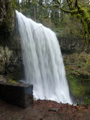
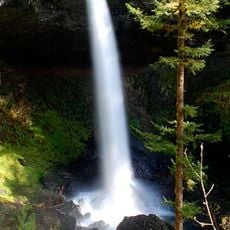
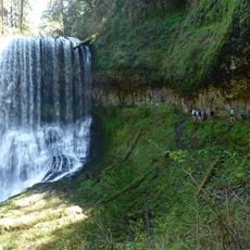
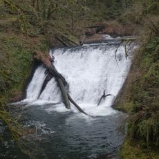
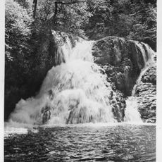
Lower South Falls, Plunge waterfall in Silver Falls State Park, Oregon, US.

Description

Lower South Falls is a plunge waterfall in Silver Falls State Park in Oregon that drops over a broad basalt ledge, creating a vertical curtain of water. The cascade maintains its full width throughout all seasons, providing a consistent and substantial flow regardless of the time of year.

History

Photographer June Drake discovered and named the falls in the 1880s while documenting the park's natural features. Her work helped bring attention to the region's waterfalls and contributed to the area's protection as a state park.

Culture

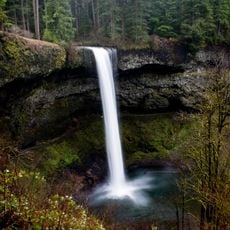
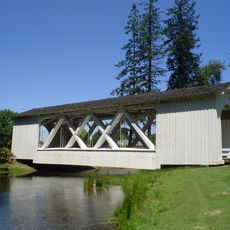
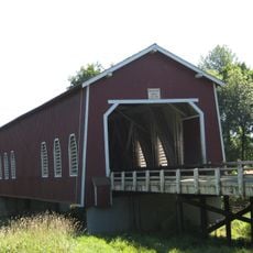
This waterfall serves as a key waypoint along the Trail of Ten Falls, connecting visitors through a series of natural cascades across the park. The site draws people who want to experience multiple falls within a single outing rather than visiting them separately.

Practical

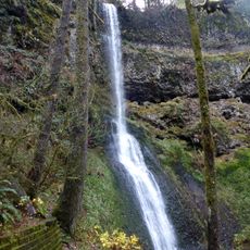
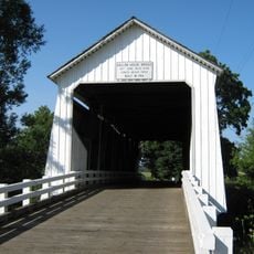
The hike starts from the main parking area and covers roughly a half-mile (800 meters) on well-maintained trails within the park. The route is clearly marked and accessible for most visitors, though sturdy shoes are helpful on the sometimes damp paths.

Did you know?

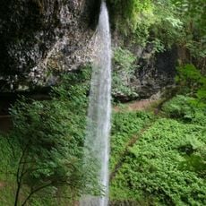
The path leads through a stone tunnel behind the cascade, allowing visitors to stand beneath and within the falls themselves. This interior vantage point shows how the water moves and sounds up close in a way few other locations offer.

Location
GPS coordinates
44.88537,-122.66102
Latest update
December 14, 2025 18:14

AroundUs brings together thousands of curated places, local tips, and hidden gems, enriched daily by 60,000 contributors worldwide. Discover all places nearby (Marion County).

Around this place
Silver Falls State Park
United States of America

Silver Falls State Park

5.2 km
Gordon House
United States of America

Gordon House

16.1 km
Oregon Garden
United States of America

Oregon Garden

16 km
Shellburg Falls
United States of America

Shellburg Falls

9.1 km
St. Mary's Roman Catholic Church
United States of America

St. Mary's Roman Catholic Church

23.1 km
Calvary Lutheran Church and Parsonage
United States of America

Calvary Lutheran Church and Parsonage

16.2 km
Winter Falls
United States of America

Winter Falls

1.6 km
Stayton–Jordan Bridge
United States of America

Stayton–Jordan Bridge

13.8 km
Gallon House Bridge
United States of America

Gallon House Bridge

19.6 km
North Falls
United States of America

North Falls

3 km
Palace Theatre
United States of America

Palace Theatre

16.5 km
Shimanek Bridge
United States of America

Shimanek Bridge

22 km
Hannah Bridge
United States of America

Hannah Bridge

19.8 km
Mt. Pleasant Community Church
United States of America

Mt. Pleasant Community Church

15.6 km
Middle North Falls
United States of America

Middle North Falls

1.5 km
Drake Falls
United States of America

Drake Falls

1.3 km
Lower North Falls
United States of America

Lower North Falls

1.3 km
June D. Drake House
United States of America

June D. Drake House

16.2 km
David and Maggie Aegerter Barn
United States of America

David and Maggie Aegerter Barn

16.6 km
Miller Cemetery Church
United States of America

Miller Cemetery Church

17.9 km
Louis J. Adams House
United States of America

Louis J. Adams House

16.4 km
Murton E. and Lillian DeGuire House
United States of America

Murton E. and Lillian DeGuire House

16.7 km
Mount Angel Abbey Library
United States of America

Mount Angel Abbey Library

21.2 km
Gordon House
United States of America

Gordon House

16.1 km
Twin Falls
United States of America

Twin Falls

1.9 km
Silverton Commercial Historic District
United States of America

Silverton Commercial Historic District

16.5 km
Silver Falls State Park Concession Building Area
United States of America

Silver Falls State Park Concession Building Area

838 m
South Falls Lodge
United States of America

South Falls Lodge

838 m
Show the full map
« Lower South Falls - Plunge waterfall in Silver Falls State Park, Oregon, US » is provided by Around Us (aroundus.com). Images and texts are derived from Wikimedia project under a Creative Commons license. You are allowed to copy, distribute, and modify copies of this page, under the conditions set by the license, as long as this note is clearly visible.

Discover hidden gems everywhere you go!

From secret cafés to breathtaking viewpoints, skip the crowded tourist spots and find places that match your style. Our app makes it easy with voice search, smart filtering, route optimization, and insider tips from travelers worldwide. Download now for the complete mobile experience.

Around Us App Screenshot

A unique approach to discovering new places

Le Figaro

All the places worth exploring

France Info

A tailor-made excursion in just a few clicks

20 Minutes

Around Us
Travel Guide & Maps
Download

Send to your phone

QR Code
1

Open the camera app on your mobile.

2

Point at the QR code with your camera. A notification will appear.

3

Tap the notification to open the link.