Enable Location

We need your location to show you interesting places around you

Discover nearby places

Find interesting locations and hidden gems around you

Precise directions

Get accurate directions and distances to places

Your location is never shared with other users. It's only used when you tap the location button.

Stayton–Jordan Bridge

Log in to your account

Start exploring — it's free

Trusted by 61,514 travelers worldwide

Continue with Google
Continue with Apple
or

We will send you a code to connect

By continuing, you accept our Terms and Conditions and our Privacy Policy

Check your inbox

We've sent a pincode in your inbox. Please enter the code below.

Stayton–Jordan Bridge

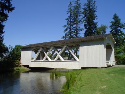
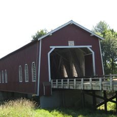
Stayton–Jordan Bridge, Covered bridge in Stayton, Oregon.

Description

The Stayton-Jordan Bridge is a covered footbridge that crosses the Salem Power Canal with a timber truss structure. It connects both banks of the waterway and is located within a park setting where community events take place.

History

An original bridge from 1937 was relocated to Stayton in 1988, but fire destroyed it in 1994. The current bridge was reconstructed by the community in 1998.

Culture

The bridge carries the Jordan name and symbolizes the community's connection to its craft heritage. Visitors can observe how wooden structures are built using traditional methods and how much the community values this construction approach.

Practical

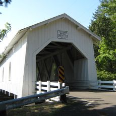
The bridge is easily reached within Pioneer Park, where visitors can park and access it on foot. The site is open for walking and invites exploration of the surrounding area.

Did you know?

Marines participated in rebuilding the first relocated bridge section, showing how military units joined community projects. This was an unusual example of collaboration between military personnel and local residents.

Official opening
1998
GPS coordinates
44.79867,-122.78589
Latest update
December 14, 2025 13:03

AroundUs brings together thousands of curated places, local tips, and hidden gems, enriched daily by 60,000 contributors worldwide. Discover all places nearby (United States of America).

Around this place
Silver Falls State Park
United States of America

Silver Falls State Park

15.4 km
Enchanted Forest
United States of America

Enchanted Forest

18 km
Thrill-Ville USA
United States of America

Thrill-Ville USA

18 km
Oregon Garden
United States of America

Oregon Garden

21.9 km
Shellburg Falls
United States of America

Shellburg Falls

14.1 km
Winter Falls
United States of America

Winter Falls

14.9 km
North Falls
United States of America

North Falls

16.1 km
Lower South Falls
United States of America

Lower South Falls

13.8 km
Hoffman Bridge
United States of America

Hoffman Bridge

18.2 km
Shimanek Bridge
United States of America

Shimanek Bridge

9.4 km
Gilkey Bridge
United States of America

Gilkey Bridge

15.4 km
Larwood Bridge
United States of America

Larwood Bridge

19.1 km
Jefferson Methodist Church
United States of America

Jefferson Methodist Church

19.7 km
Hannah Bridge
United States of America

Hannah Bridge

11 km
Mt. Pleasant Community Church
United States of America

Mt. Pleasant Community Church

5.6 km
Middle North Falls
United States of America

Middle North Falls

15.1 km
Drake Falls
United States of America

Drake Falls

15 km
Henry and Mary Cyrus Barn
United States of America

Henry and Mary Cyrus Barn

21 km
Prewitt–Allen Archaeological Museum
United States of America

Prewitt–Allen Archaeological Museum

16.7 km
Lower North Falls
United States of America

Lower North Falls

15.1 km
Z.C.B.J. Tolstoj Lodge No. 224
United States of America

Z.C.B.J. Tolstoj Lodge No. 224

15.5 km
Joseph Wesely House and Barn
United States of America

Joseph Wesely House and Barn

12.3 km
David and Maggie Aegerter Barn
United States of America

David and Maggie Aegerter Barn

6.5 km
Delaney–Edwards House
United States of America

Delaney–Edwards House

15.5 km
E. C. Perry Building
United States of America

E. C. Perry Building

11.5 km
Twin Falls
United States of America

Twin Falls

15.2 km
Silver Falls State Park Concession Building Area
United States of America

Silver Falls State Park Concession Building Area

13.5 km
South Falls Lodge
United States of America

South Falls Lodge

13.5 km
Show the full map
« Stayton–Jordan Bridge - Covered bridge in Stayton, Oregon » is provided by Around Us (aroundus.com). Images and texts are derived from Wikimedia project under a Creative Commons license. You are allowed to copy, distribute, and modify copies of this page, under the conditions set by the license, as long as this note is clearly visible.

Discover hidden gems everywhere you go!

From secret cafés to breathtaking viewpoints, skip the crowded tourist spots and find places that match your style. Our app makes it easy with voice search, smart filtering, route optimization, and insider tips from travelers worldwide. Download now for the complete mobile experience.

Around Us App Screenshot

A unique approach to discovering new places

Le Figaro

All the places worth exploring

France Info

A tailor-made excursion in just a few clicks

20 Minutes

Around Us
Travel Guide & Maps
Download

Send to your phone

QR Code
1

Open the camera app on your mobile.

2

Point at the QR code with your camera. A notification will appear.

3

Tap the notification to open the link.