Enable Location

We need your location to show you interesting places around you

Discover nearby places

Find interesting locations and hidden gems around you

Precise directions

Get accurate directions and distances to places

Your location is never shared with other users. It's only used when you tap the location button.

Larwood Bridge

Log in to your account

Start exploring — it's free

Trusted by 61,830 travelers worldwide

Continue with Google
Continue with Apple
or

We will send you a code to connect

By continuing, you accept our Terms and Conditions and our Privacy Policy

Check your inbox

We've sent a pincode in your inbox. Please enter the code below.

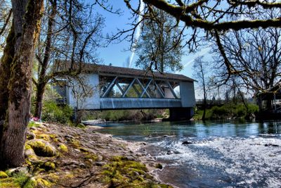
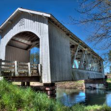
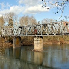
Larwood Bridge, Covered bridge in Crabtree, United States.

Description

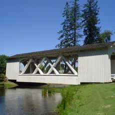
Larwood Bridge is a covered wooden bridge in Crabtree that spans about 105 feet across Crabtree Creek. The structure uses traditional Howe truss construction and sits where Roaring River flows into the creek.

History

The bridge was built between 1939 and 1941, after William Larwood had established a settlement here in 1888. Its construction met the needs of the growing farming community for a reliable crossing.

Culture

The name comes from William Larwood, who founded a settlement in this area during the 1800s. The bridge reflects how communities built sturdy crossings to connect farms and settlements across the creek.

Practical

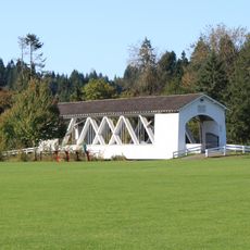
The best access is via Fish Hatchery Road, and the adjacent Larwood Wayside Park provides parking, picnic areas, and swimming facilities. The site is also good for photographers, especially during changing daylight when the wooden structure is most visible.

Did you know?

The spot where Roaring River flows into Crabtree Creek is geographically unusual and was even noted by Ripley's Believe It or Not. This rare water confluence makes the bridge location particularly worth noting for nature watchers.

Location
Inception
1939
GPS coordinates
44.63031,-122.74078
Latest update
December 14, 2025 18:46

AroundUs brings together thousands of curated places, local tips, and hidden gems, enriched daily by 60,000 contributors worldwide. Discover all places nearby (Linn County).

Around this place
Silver Falls State Park
United States of America

Silver Falls State Park

27.3 km
Foster Reservoir
United States of America

Foster Reservoir

24.5 km
Green Peter Reservoir
United States of America

Green Peter Reservoir

25.1 km
Santiam State Forest
United States of America

Santiam State Forest

27.3 km
Shellburg Falls
United States of America

Shellburg Falls

22.8 km
Green Peter Dam
United States of America

Green Peter Dam

25.2 km
Albany Municipal Airport
United States of America

Albany Municipal Airport

25.3 km
Stayton–Jordan Bridge
United States of America

Stayton–Jordan Bridge

19.1 km
Weddle Bridge
United States of America

Weddle Bridge

26.4 km
Hoffman Bridge
United States of America

Hoffman Bridge

12.1 km
Shimanek Bridge
United States of America

Shimanek Bridge

10.7 km
Gilkey Bridge
United States of America

Gilkey Bridge

14.4 km
Jefferson Methodist Church
United States of America

Jefferson Methodist Church

23.5 km
Hannah Bridge
United States of America

Hannah Bridge

9.3 km
Mt. Pleasant Community Church
United States of America

Mt. Pleasant Community Church

14.3 km
Henry and Mary Cyrus Barn
United States of America

Henry and Mary Cyrus Barn

11.4 km
Z.C.B.J. Tolstoj Lodge No. 224
United States of America

Z.C.B.J. Tolstoj Lodge No. 224

5.9 km
Joseph Wesely House and Barn
United States of America

Joseph Wesely House and Barn

11.3 km
Methodist Episcopal Church South
United States of America

Methodist Episcopal Church South

28.5 km
David and Maggie Aegerter Barn
United States of America

David and Maggie Aegerter Barn

13.1 km
Louis A. Crandall House
United States of America

Louis A. Crandall House

16.7 km
Hackleman Historic District
United States of America

Hackleman Historic District

28.4 km
E. C. Perry Building
United States of America

E. C. Perry Building

11.8 km
Angell–Brewster House
United States of America

Angell–Brewster House

11.7 km
Rio Theatre
United States of America

Rio Theatre

25.9 km
Silver Falls State Park Concession Building Area
United States of America

Silver Falls State Park Concession Building Area

28.4 km
Toledo District Willamette Bridge
United States of America

Toledo District Willamette Bridge

28.2 km
South Falls Lodge
United States of America

South Falls Lodge

28.4 km
Show the full map
« Larwood Bridge - Covered bridge in Crabtree, United States » is provided by Around Us (aroundus.com). Images and texts are derived from Wikimedia project under a Creative Commons license. You are allowed to copy, distribute, and modify copies of this page, under the conditions set by the license, as long as this note is clearly visible.

Discover hidden gems everywhere you go!

From secret cafés to breathtaking viewpoints, skip the crowded tourist spots and find places that match your style. Our app makes it easy with voice search, smart filtering, route optimization, and insider tips from travelers worldwide. Download now for the complete mobile experience.

Around Us App Screenshot

A unique approach to discovering new places

Le Figaro

All the places worth exploring

France Info

A tailor-made excursion in just a few clicks

20 Minutes

Around Us
Travel Guide & Maps
Download

Send to your phone

QR Code
1

Open the camera app on your mobile.

2

Point at the QR code with your camera. A notification will appear.

3

Tap the notification to open the link.