Enable Location

We need your location to show you interesting places around you

Discover nearby places

Find interesting locations and hidden gems around you

Precise directions

Get accurate directions and distances to places

Your location is never shared with other users. It's only used when you tap the location button.

Mt. Pleasant Community Church

Log in to your account

Start exploring — it's free

Trusted by 62,304 travelers worldwide

Continue with Google
Continue with Apple
or

We will send you a code to connect

By continuing, you accept our Terms and Conditions and our Privacy Policy

Check your inbox

We've sent a pincode in your inbox. Please enter the code below.

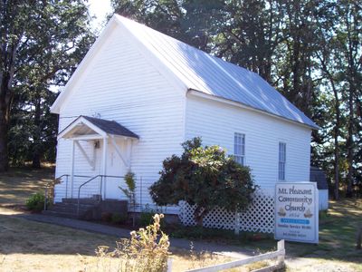
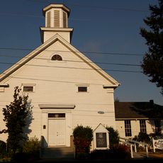
Mt. Pleasant Community Church, church and historic church building in Oregon, USA

Mt. Pleasant Community Church is a church building in Linn County, Oregon, built in 1854 with a simple and sturdy design using local materials. The structure features a small steeple, plain windows that allow light inside, and wooden pews arranged in a spacious but intimate interior.

The church was built in 1854 before Oregon became a state and originally served two Christian groups, the Cumberland Presbyterians and the Christian church, who shared the space. Tensions arose between these groups but eventually resolved, allowing them to worship together in the same building.

The church served as a gathering place where different religious groups came together, shaping how the community formed its identity. Today, visitors can observe how this space brought people together across differences and became central to local life.

The church is located in a quiet area near Stayton, across the Santiam River, and is easy to spot from the main road. Visitors are welcomed by friendly signage and can observe services or community events, particularly on weekends when the building is most active.

A landowner named Washington Crabtree once filled the church building with hay for two years to interrupt conflicts between the two religious groups sharing the space. This unusual act reveals how tense disputes became and how creative local people tried to bring peace.

The community of curious travelers

AroundUs brings together thousands of curated places, local tips, and hidden gems, enriched daily by 60,000 contributors worldwide.

Start exploring
Location
GPS coordinates
44.75861,-122.74389
Latest update
February 9, 2026 07:40
Around this place
Silver Falls State Park
United States of America

Silver Falls State Park

15.3 km
Enchanted Forest
United States of America

Enchanted Forest

22.5 km
Thrill-Ville USA
United States of America

Thrill-Ville USA

22.5 km
Shellburg Falls
United States of America

Shellburg Falls

12.3 km
Winter Falls
United States of America

Winter Falls

16.2 km
Stayton–Jordan Bridge
United States of America

Stayton–Jordan Bridge

5.6 km
North Falls
United States of America

North Falls

17 km
Lower South Falls
United States of America

Lower South Falls

15.6 km
Hoffman Bridge
United States of America

Hoffman Bridge

16.5 km
Shimanek Bridge
United States of America

Shimanek Bridge

6.8 km
Gilkey Bridge
United States of America

Gilkey Bridge

14.9 km
Larwood Bridge
United States of America

Larwood Bridge

14.3 km
Jefferson Methodist Church
United States of America

Jefferson Methodist Church

21.4 km
Hannah Bridge
United States of America

Hannah Bridge

5.6 km
Middle North Falls
United States of America

Middle North Falls

16.5 km
Drake Falls
United States of America

Drake Falls

16.5 km
Henry and Mary Cyrus Barn
United States of America

Henry and Mary Cyrus Barn

18.7 km
Prewitt–Allen Archaeological Museum
United States of America

Prewitt–Allen Archaeological Museum

22 km
Lower North Falls
United States of America

Lower North Falls

16.7 km
Z.C.B.J. Tolstoj Lodge No. 224
United States of America

Z.C.B.J. Tolstoj Lodge No. 224

11.9 km
Joseph Wesely House and Barn
United States of America

Joseph Wesely House and Barn

10.7 km
David and Maggie Aegerter Barn
United States of America

David and Maggie Aegerter Barn

1.1 km
Delaney–Edwards House
United States of America

Delaney–Edwards House

20.3 km
E. C. Perry Building
United States of America

E. C. Perry Building

10.1 km
Angell–Brewster House
United States of America

Angell–Brewster House

22.3 km
Twin Falls
United States of America

Twin Falls

16.4 km
Silver Falls State Park Concession Building Area
United States of America

Silver Falls State Park Concession Building Area

15 km
South Falls Lodge
United States of America

South Falls Lodge

15 km
Show the full map
« Mt. Pleasant Community Church - church and historic church building in Oregon, USA » is provided by Around Us (aroundus.com). Images and texts are derived from Wikimedia project under a Creative Commons license. You are allowed to copy, distribute, and modify copies of this page, under the conditions set by the license, as long as this note is clearly visible.

Discover hidden gems everywhere you go!

From secret cafés to breathtaking viewpoints, skip the crowded tourist spots and find places that match your style. Our app makes it easy with voice search, smart filtering, route optimization, and insider tips from travelers worldwide. Download now for the complete mobile experience.

Around Us App Screenshot

A unique approach to discovering new places

Le Figaro

All the places worth exploring

France Info

A tailor-made excursion in just a few clicks

20 Minutes

Around Us
Travel Guide & Maps
Download

Send to your phone

QR Code
1

Open the camera app on your mobile.

2

Point at the QR code with your camera. A notification will appear.

3

Tap the notification to open the link.