
Tarenguet Ehel Moul, commune and village in Mauritania
Location: M'Bout Department
Location: Gorgol Region
GPS coordinates: 15.84086,-12.39837
Latest update: March 5, 2025 03:25

Great Mosque of Touba
387.8 km
Niokolo-Koba National Park
323.5 km
River Gambia National Park
368.9 km
MacCarthy Island
361.9 km
Gouina Falls
246.5 km
Bassari Country
364.7 km
Badiar National Park
372.3 km
Dindefelo Falls
387 km
Félou Falls
200.3 km
Lake Manantali
371.8 km
Talari Gorges
276 km
Cercles de pierres de Wassu
357.2 km
Deer Island (Gambia)
370.6 km
Isla Sepu
368.4 km
Tata of Koniakary
213.6 km
Isla Brikama
373.6 km
Bird Island
360.9 km
Eisenbahnbrücke von Kidira
155.1 km
Cercles de pierres de Kerbatch
372.4 km
Sankulay Kunda Bridge
362.5 km
Straßenbrücke von Kidira
155.6 km
Isla Pangon
361.4 km
Isla Pasari
299.1 km
Isla Ba Faraba
385.6 km
Mimang Island
370.6 km
Pappa Island
390.2 km
Fort de Médine
197 km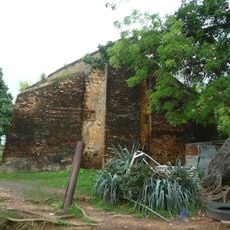
Slave House
360.9 kmReviews
Visited this place? Tap the stars to rate it and share your experience / photos with the community! Try now! You can cancel it anytime.
Discover hidden gems everywhere you go!
From secret cafés to breathtaking viewpoints, skip the crowded tourist spots and find places that match your style. Our app makes it easy with voice search, smart filtering, route optimization, and insider tips from travelers worldwide. Download now for the complete mobile experience.

A unique approach to discovering new places❞
— Le Figaro
All the places worth exploring❞
— France Info
A tailor-made excursion in just a few clicks❞
— 20 Minutes