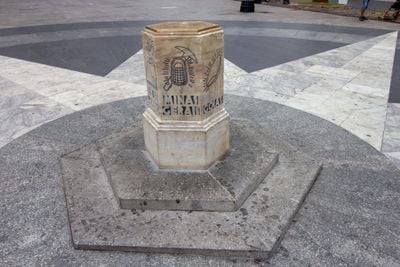
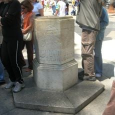
Number zero survey marker of the city of São Paulo, Geographic monument in Praça da Sé, São Paulo, Brazil
This hexagonal marble marker stands in front of São Paulo Cathedral and marks the point from which all road distances across the city are measured. The structure is made of marble, bronze, and granite, measuring about 2.2 m wide and 0.15 m in height.
This monument was inaugurated in 1934 and became South America's first geographic reference point following a proposal by journalist Américo R. Netto made in 1921. The creation established the city as a model for regional distance measurement systems.
The six sides of this marker display bronze engravings showing symbols from different Brazilian regions, such as Santos depicted with a steamship and Paraná with an Araucaria tree. These regional representations reflect the city's connection to the surrounding areas.
The marker is located at Praça da Sé, where multiple metro lines intersect, making it a central meeting point in downtown. Visitors can reach this location easily thanks to the extensive public transit network throughout the area.
A bronze plaque on the marker records important locations in São Paulo from 1934, including Paulista Avenue, Ipiranga Museum, and the Tietê River. This historical record offers a glimpse into the city's landscape from decades ago.
The community of curious travelers
AroundUs brings together thousands of curated places, local tips, and hidden gems, enriched daily by 60,000 contributors worldwide.