Enable Location

We need your location to show you interesting places around you

Discover nearby places

Find interesting locations and hidden gems around you

Precise directions

Get accurate directions and distances to places

Your location is never shared with other users. It's only used when you tap the location button.

Itapemirim

Log in to your account

Start exploring — it's free

Trusted by 64,404 travelers worldwide

Continue with Google
Continue with Apple
or

We will send you a code to connect

By continuing, you accept our Terms and Conditions and our Privacy Policy

Check your inbox

We've sent a pincode in your inbox. Please enter the code below.

Discussion Reviews 1 Photos
18.8k Popularity

Itapemirim, municipality of Espírito Santo, Brazil

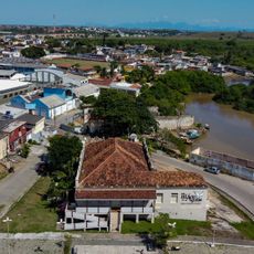
Itapemirim is a municipality in southern Espírito Santo located near the coast with mountains inland. The area features rocky landscapes carved by rivers and small settlements with low buildings and quiet streets that lead toward nearby beaches.

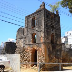
The town was officially established in 1816 as Nossa Senhora do Amparo de Itapemirim after families like the Gomes Bittencourt led settlement in the river valley. During the 1800s, growth came through river trade and the port became a hub for exporting sugar, spirits, and coffee until some territories separated to form new communities.

The town takes its name from the Itapemirim River, which shaped early settlement and remains visible in local music and traditional architecture. This connection to the river is part of how residents understand and talk about their community today.

The town sits roughly 122 kilometers from Vitória and is accessible via the Rodovia do Sol or BR-101 highway. The streets are easy to navigate on foot, and visitors can explore the old buildings and natural surroundings at a relaxed pace.

Many old houses in town were built from stones that sailors used as ballast in ships and later discarded in the water. This practice left enough material for people to construct buildings that still stand today as a visible reminder of the place's maritime past.

The community of curious travelers

AroundUs brings together thousands of curated places, local tips, and hidden gems, enriched daily by 60,000 contributors worldwide.

Start exploring
Location
Elevation above the sea
5 m
Shares border with
Marataízes, Atilio Vivaqua, Cachoeiro de Itapemirim, Piúma, Presidente Kennedy, Rio Novo do Sul, Vargem Alta
GPS coordinates
-21.01083,-40.83389
Latest update
February 16, 2026 23:20
Reviews
Share your experience

No review yet

Discussions
Start a discussion...

No discussion yet

« Itapemirim - municipality of Espírito Santo, Brazil » is provided by Around Us (aroundus.com). Images and texts are derived from Wikimedia project under a Creative Commons license. You are allowed to copy, distribute, and modify copies of this page, under the conditions set by the license, as long as this note is clearly visible.

Discover hidden gems everywhere you go!

From secret cafés to breathtaking viewpoints, skip the crowded tourist spots and find places that match your style. Our app makes it easy with voice search, smart filtering, route optimization, and insider tips from travelers worldwide. Download now for the complete mobile experience.

Around Us App Screenshot

A unique approach to discovering new places

Le Figaro

All the places worth exploring

France Info

A tailor-made excursion in just a few clicks

20 Minutes

Around Us
Travel Guide & Maps
Download

Send to your phone

QR Code
1

Open the camera app on your mobile.

2

Point at the QR code with your camera. A notification will appear.

3

Tap the notification to open the link.