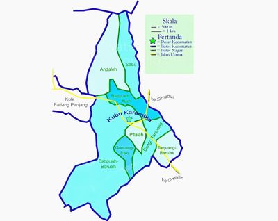
Batipuh, district in Tanah Datar Regency, West Sumatra Province, Indonesia
Location: Tanah Datar
Elevation above the sea: 363 m
GPS coordinates: -0.47719,100.46168
Latest update: April 3, 2025 11:27
Marapi
9.6 km
Minangkabau Culture Documentation and Information Center
9.3 km
Fort van der Capellen
14.9 km
Prasasti Kuburajo I
12.3 km
Asasi Mosque
4 km
Lima Kaum Mosque
11.9 km
Rumah Gadang Kampai Nan Panjang
13.1 km
Lubuk Bauk Mosque
570 m
Saadah Mosque
11.4 km
Balairung Sari Tabek
6.9 km
Padang Panjang Railway Bridge
10.5 km
Ishlah Pariangan Mosque
3.8 km
Jamik Sungai Jambu Mosque
7.3 km
Tuanku Pamansiangan Mosque
9.7 km
Rahmah El Yunusiyah Museum
7.3 km
Masjid Zu'ama Jembatan Besi
7.1 km
Masjid Makmur Simabur
5.6 km
Terraced rice fields
4.1 km
Masjid Nurul Iman Bungo Tanjuang
3.3 km
Batagak Grand Mosque
14.4 km
Islamic Center Padang Panjang
5.7 km
Jamik Darussalam Kotobaru Mosque
11.3 km
Syuhada Sariak Mosque
14.2 km
Jihaadu Waalidaina Mosque
7 km
Masjid Jamik Batu Palano
12.4 km
Masjid Jamik Kapalo Koto
14.2 km
Surau Kinawai
13.5 km
Musala Nurshalihin
7 kmReviews
Visited this place? Tap the stars to rate it and share your experience / photos with the community! Try now! You can cancel it anytime.
Discover hidden gems everywhere you go!
From secret cafés to breathtaking viewpoints, skip the crowded tourist spots and find places that match your style. Our app makes it easy with voice search, smart filtering, route optimization, and insider tips from travelers worldwide. Download now for the complete mobile experience.
A unique approach to discovering new places❞
— Le Figaro
All the places worth exploring❞
— France Info
A tailor-made excursion in just a few clicks❞
— 20 Minutes