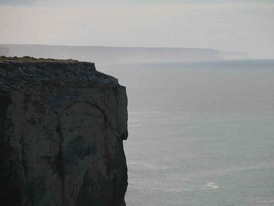
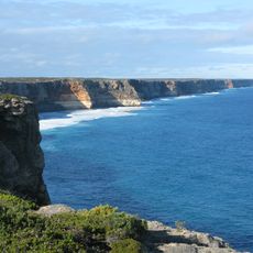
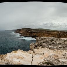
Bunda Cliffs, Limestone sea cliffs in South Australia.
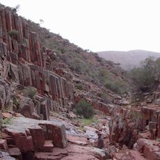
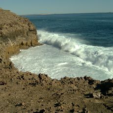
Bunda Cliffs are limestone escarpments along South Australia's southern coast, stretching for hundreds of kilometers above the Great Australian Bight. The rock walls rise steeply from the ocean and expose layers of marine sediments and fossils in their exposed faces.
These cliffs formed roughly 65 million years ago when Australia drifted away from Antarctica. The separation created geological conditions that allowed marine sediments to accumulate and solidify into the limestone we see today.
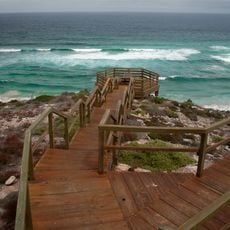
The name comes from an Aboriginal language and received official recognition in 2014. Visitors often pause here to take in how the cliffs meet the ocean and the vast emptiness beyond.
Several viewpoints along the Eyre Highway offer convenient access for observing the cliffs and the coastline. Visiting during the Southern Right Whale migration season provides opportunities to spot these marine mammals from the ridge above.
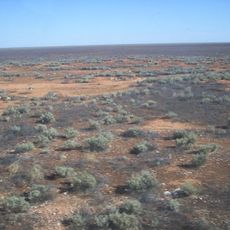
The limestone foundation forms part of the Nullarbor Plain, which is the largest continuous limestone platform on Earth. This makes the site geologically rare and shapes how water flows beneath the surface across an enormous area.
Location: South Australia
GPS coordinates: -31.95000,130.23333
Latest update: December 6, 2025 17:49
Cliffs rank among Earth's most striking geological formations, ranging from coastal precipices to inland mountain faces. Along oceans, they shape coastlines for thousands of miles, while in mountain regions they form vertical walls that draw climbers from around the world. This collection documents significant cliffs across six continents, including Ireland's 214-meter (702-foot) Cliffs of Moher, England's white chalk cliffs at Dover, and Norway's Preikestolen, which rises 604 meters (1,982 feet) above Lysefjord. Among the locations are some of Earth's highest vertical walls. Hawaii's Kalaupapa Cliffs on Molokai reach 1,010 meters (3,315 feet), while Pakistan's Trango Towers rise above 6,000 meters (19,685 feet) with nearly vertical rock faces. Coastal formations like Normandy's Étretat cliffs, Ireland's Slieve League, and Australia's Bunda Cliffs along the Nullarbor Plain demonstrate the power of marine erosion. Inland, formations such as California's El Capitan, China's Zhangjiajie National Forest Park towers, and South Africa's Table Mountain create distinctive landscape features shaped by different geological processes over millions of years.
Mundrabilla
286.2 km
Coffin Bay National Park
556.6 km
Murphys Haystacks
417 km
Murrawijinie Cave
89.3 km
Australian Farmer
505.9 km
Gawler Ranges National Park
495.2 km
Nullarbor National Park
99 km
Lake Gairdner National Park
547.4 km
Acraman Creek Conservation Park
363.9 km
Eyre Telegraph Station
372.3 km
Eucla National Park
123.5 km
Ilkulka Community
476.8 km
Toolinna Cove
498 km
Penong Windmill Museum
262.3 km
Talia Beach
455.1 km
Hall Beach
520.4 km
Almonta Beach
564.2 km
Loch Well Beach
490.4 km
Whistling Hill
371.9 km
Long Beach
569.5 km
Rawlinna Townsite
477 km
Eucla Telegraph Station
130.1 km
St Francis of Assisi Catholic Church, Elliston
474.7 km
Eucla Jetty
129.8 km
Venus Bay Jetty
440.1 km
Smoky Bay Jetty
351.9 km
Smoky Bay Community Church
352 km
Small Stony Lighthouse
473.7 kmVisited this place? Tap the stars to rate it and share your experience / photos with the community! Try now! You can cancel it anytime.
Discover hidden gems everywhere you go!
From secret cafés to breathtaking viewpoints, skip the crowded tourist spots and find places that match your style. Our app makes it easy with voice search, smart filtering, route optimization, and insider tips from travelers worldwide. Download now for the complete mobile experience.
A unique approach to discovering new places❞
— Le Figaro
All the places worth exploring❞
— France Info
A tailor-made excursion in just a few clicks❞
— 20 Minutes