Mount Rinjani National Park, National park in West Nusa Tenggara, Indonesia.
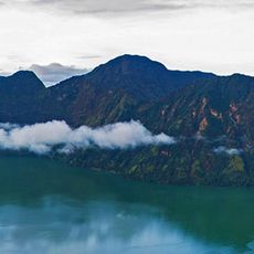
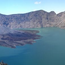
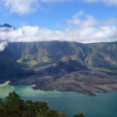
Mount Rinjani National Park covers about 41,330 hectares of mountainous terrain on Lombok, in North Lombok Regency. At its centre rises Mount Rinjani, Indonesia's third-highest volcano at 3,726 metres. Inside the summit crater lies Segara Anak, a caldera lake roughly 1,100 hectares in extent and estimated 160 to 230 metres deep, with the young cone of Gunung Baru Jari emerging from its middle.
The area received its official status as a national park in 1990, providing legal protection for the island's ecosystems. This protection measure came from recognizing the ecological importance and diversity of the volcano and its surroundings.
Sasak and Hindu Dharma communities on Lombok perform the Mulang Pekelem ritual, asking Dewi Anjani for rain by sinking gold plates shaped like water creatures into Segara Anak. Dewi Anjani is said to descend from a king of Selaparang and a spirit dwelling on Rinjani. The lake's name means "small sea" in Sasak.
The park's boundaries were fixed by the Minister of Forestry on 1 February 2007, splitting it across West, Central and East Lombok regencies. East Lombok holds 22,152.88 hectares (53%), West Lombok 12,357.67 hectares (30%) and Central Lombok 6,819.45 hectares (17%). Entry points sit in the sanggraloka sectors, including Senaru, Santong, Sembalun, Aikmel, Aikberik and Joben, each with guard posts.
The park sits on Wallace's Line, a natural boundary where plants and animals from Asian and Australian origins meet and live together. This geographical crossroads makes it a rare place where visitors can experience both biological regions in one landscape.
The community of curious travelers
AroundUs brings together thousands of curated places, local tips, and hidden gems, enriched daily by 93,443 contributors worldwide.