Muna, Administrative regency in Southeast Sulawesi, Indonesia
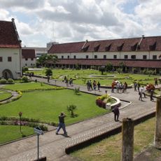
Muna is an administrative regency in Southeast Sulawesi that encompasses multiple islands divided into twenty-two districts. Raha serves as the administrative center and is linked to rural villages and urban areas throughout the territory.
The regency was split in 2014 when its western section separated to form West Muna Regency. This division reduced the original territory to its current form.
The motto 'Sowite' means 'For the sake of my land' and expresses how deeply people here feel connected to their home. This sense of belonging shapes life in the villages and brings the island communities together.
The regency is organized into multiple administrative units that serve both rural villages and urban areas. Visitors will find basic services and infrastructure available in Raha and throughout the smaller settlements.
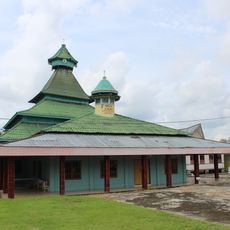
The Al Munajat Mosque in Raha displays regional architectural styles and serves as a central gathering place. Its design reflects local building traditions and religious importance to the community.
Location: Southeast Sulawesi
Capital city: Raha
Elevation above the sea: 150 m
Shares border with: North Buton, Buton, Central Buton, West Muna
GPS coordinates: -4.84250,122.64800
Latest update: December 7, 2025 10:08
Fort Rotterdam
361 km
Wakatobi National Park
177.7 km
Bantimurung – Bulusaraung National Park
321.5 km
Pettakere cave
328.1 kmJesus Buntu Burake
364.9 km
Taka Bone Rate National Park
263.7 km
Kete Kesu
366.5 km
Buntu Rantemario
333.3 kmAl-Alam Kendari Mosque
96.9 km
Palopo Old Mosque
341.4 km
Great Mosque of Makassar
359.4 km
Lewotolo
393.4 km
Balla Lompoa Museum
356.7 km
Sacred Heart Cathedral, Makassar
360.6 km
Al-Markaz Al-Islami Mosque
358.7 km
Rokatenda
400.5 km
Rawa Aopa Watumohai National Park
89.7 km
Batu Tara
344.1 km
La Galigo Museum
361.1 km
Makassar Museum
360.7 km
Iliboleng
395.5 km
Karaeng Pattingalloang Museum
361.8 km
Kassi Kebo Stadium
342.1 km
Grand Mosque of Makassar
359.4 km
Ilimuda
404.7 km
Monument gevallenen Boni-expeditie 1905-1906
361.1 km
Masjid Jami Koto Pangean 1931
362.5 km
Benteng weir
354 kmVisited this place? Tap the stars to rate it and share your experience / photos with the community! Try now! You can cancel it anytime.
Discover hidden gems everywhere you go!
From secret cafés to breathtaking viewpoints, skip the crowded tourist spots and find places that match your style. Our app makes it easy with voice search, smart filtering, route optimization, and insider tips from travelers worldwide. Download now for the complete mobile experience.
A unique approach to discovering new places❞
— Le Figaro
All the places worth exploring❞
— France Info
A tailor-made excursion in just a few clicks❞
— 20 Minutes