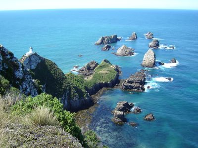
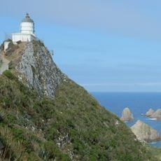
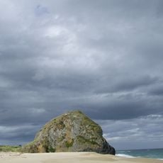
Nugget Point, Coastal viewpoint in Clutha District, New Zealand
A series of wave-eroded rocks rise from the Pacific Ocean near the lighthouse, forming distinct shapes that resemble gold nuggets along the coastline.
The lighthouse at Nugget Point began operations in 1870, constructed from local stone to guide ships navigating the challenging waters of the Otago coast.
The Maori name for Nugget Point, Tokatā, reflects the deep connection of indigenous peoples to this maritime location through generations.
The site includes a parking area and a maintained walking track that leads visitors to the lighthouse viewing platform within a 20-minute return journey.
Fur seals establish breeding colonies on the rocks below, while yellow-eyed penguins return from their daily fishing trips at Roaring Bay.
Location: Clutha District
Elevation above the sea: 3 m
GPS coordinates: -46.44750,169.81400
Latest update: March 7, 2025 13:37
New Zealand provides photographic subjects ranging from the Southern Alps to sand beaches on both coastlines. The landscape includes thermal springs in Rotorua, glaciers like Franz Josef and Tasman, and fjords in Fiordland. Mount Cook dominates the alpine region while the Coromandel Peninsula holds beaches including Hot Water Beach and Cathedral Cove. The Tongariro Alpine Crossing traverses volcanic terrain and Mount Taranaki rises above Taranaki. Coastal formations like the Moeraki Boulders, Split Apple Rock and Nugget Point demonstrate geological variety. Natural waterfalls including Purakaunui Falls and Whangarei Falls sit among native forests. Cultural sites complement the natural geography. The Hobbiton Movie Set near Matamata displays the film location from the Tolkien adaptation. Larnach Castle near Dunedin represents colonial architecture. Te Puia and Wai-O-Tapu demonstrate geothermal activity with geysers and colored pools. Waitomo Caves contains glowworm caverns. Lake Tekapo offers clear night skies for stargazing. Viewpoints like Roy's Peak near Wanaka and Queenstown Hill sit above lake landscapes. Remote regions including Cape Reinga at the northern tip and Cape Palliser in the Wairarapa show different coastal environments. The Forgotten World Highway crosses historic mountain country on the North Island.
Tunnel Beach
76.8 km
Purakaunui Falls
20.9 km
Nugget Point Lighthouse
225 m
McLean Falls
37.9 km
Balclutha Road Bridge
24.1 km
Maungatua
67.2 km
Niagara Falls
54.6 km
Mosgiel Woollen Mill
76.5 km
Cooks Head
34.2 km
Matai Falls
25.7 km
St Patricks Church School and Hall
60.3 km
War Memorial and Peace Garden
60.4 km
The Poplars
70.9 km
Lawrence Post Office
60.2 km
F. Martin Building
60.4 km
Owaka Museum
11.7 km
Tokomairiro Church
37.8 km
Fleming's Creamoata Mill complex
78 km
Tuapeka Mouth Punt and Jetty
53.2 km
Bank of New Zealand Building
60.3 km
Lawrence Court House
60.2 km
Bank of New South Wales
60.4 km
Gore Presbyterian Church
76.9 km
Tuapeka Times Office
60.3 km
Shops
60.3 km
East Taieri Church
74.3 km
Pukerau Red Tussock Scientific Reserve
68.8 km
Big Mosgiel Sign
75 kmReviews
Visited this place? Tap the stars to rate it and share your experience / photos with the community! Try now! You can cancel it anytime.
Discover hidden gems everywhere you go!
From secret cafés to breathtaking viewpoints, skip the crowded tourist spots and find places that match your style. Our app makes it easy with voice search, smart filtering, route optimization, and insider tips from travelers worldwide. Download now for the complete mobile experience.
A unique approach to discovering new places❞
— Le Figaro
All the places worth exploring❞
— France Info
A tailor-made excursion in just a few clicks❞
— 20 Minutes