Chest opened
+${chestReward.xp} XP
Explorer
NOUVEAU ×${chestReward.collectible.quantity}
tapez pour fermer
Chest locked

Open chests in the app

Around Us is built for your phone — chests unlock when you walk, explore and capture nearby places.

Enable Location

We need your location to show you interesting places around you

Discover nearby places

Find interesting locations and hidden gems around you

Precise directions

Get accurate directions and distances to places

Your location is never shared with other users. It's only used when you tap the location button.

Sand Island

Log in to your account

Start exploring — it's free

Trusted by 72,897 travelers worldwide

Continue with Google
Continue with Apple
or

We will send you a code to connect

By continuing, you accept our Terms and Conditions and our Privacy Policy

Check your inbox

We've sent a pincode in your inbox. Please enter the code below.

Sand Island
Discussion Reviews 1 Photos
26.7k Popularity

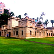
Sand Island, Coastal island near Honolulu Harbor, Hawaii

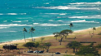
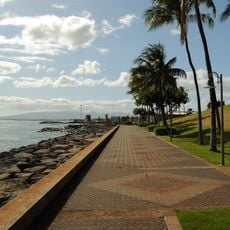
Sand Island is a 203-hectare landmass at Honolulu Harbor's entrance with sandy beaches, walking trails, and recreational facilities facing the Pacific Ocean. The property includes camping sites, picnic pavilions, restrooms, showers, and drinking water stations throughout the grounds.

During World War II, the island served as an internment camp holding over 600 residents, primarily Japanese Americans, between 1941 and 1943. This chapter remains central to understanding the site's past.

Community gatherings and local festivals connect visitors to Hawaiian traditions practiced along the island's shores. These regular events show how the place remains woven into the daily life and customs of nearby residents.

Access to the island is via Sand Island Parkway, which has several parking areas and entry points for both vehicles and pedestrians. Daytime visits work best when all facilities and paths are open and well-maintained.

Beyond recreation, the island houses a Coast Guard base and water treatment facility, revealing how leisure and infrastructure coexist on the same land. This combination shows the place serves multiple practical purposes for the wider community.

The community of curious travelers

AroundUs brings together thousands of curated places, local tips, and hidden gems, enriched daily by 60,000 contributors worldwide.

Start exploring
Location
Part of
Hawaiian Islands
GPS coordinates
21.30830,-157.88300
Latest update
December 20, 2025 14:43
Around this place
ʻIolani Palace
United States of America

ʻIolani Palace

2.5 km
Aloha Tower
United States of America

Aloha Tower

1.8 km
Izumo Taishakyo Mission of Hawaii
United States of America

Izumo Taishakyo Mission of Hawaii

2.4 km
Falls of Clyde
United States of America

Falls of Clyde

1.9 km
First Hawaiian Center
United States of America

First Hawaiian Center

2.2 km
Cathedral Basilica of Our Lady of Peace
United States of America

Cathedral Basilica of Our Lady of Peace

2.4 km
Foster Botanical Garden
United States of America

Foster Botanical Garden

2.6 km
Aliiolani Hale
United States of America

Aliiolani Hale

2.4 km
Hawaii Theatre
United States of America

Hawaii Theatre

2.3 km
Hawaii State Public Library System
United States of America

Hawaii State Public Library System

2.1 km
Hawaii State Art Museum
United States of America

Hawaii State Art Museum

2.5 km
Prince Kuhio Federal Building
United States of America

Prince Kuhio Federal Building

2.2 km
ʻIolani Barracks
United States of America

ʻIolani Barracks

2.5 km
Kakaako Waterfront Park
United States of America

Kakaako Waterfront Park

2.6 km
Kamehameha Statue
United States of America

Kamehameha Statue

2.4 km
Hawaii Maritime Center
United States of America

Hawaii Maritime Center

1.9 km
Merchant Street Historic District
United States of America

Merchant Street Historic District

2.1 km
King David Kalakaua Building
United States of America

King David Kalakaua Building

2.3 km
Kaumakapili Church
United States of America

Kaumakapili Church

2.3 km
YWCA Building
United States of America

YWCA Building

2.3 km
Lunalilo Mausoleum
United States of America

Lunalilo Mausoleum

2.6 km
United States Immigration Office
United States of America

United States Immigration Office

1.7 km
C. Brewer Building
United States of America

C. Brewer Building

1.9 km
Kakaako Pumping Station
United States of America

Kakaako Pumping Station

1.9 km
Royal Brewery
United States of America

Royal Brewery

2.5 km
Stangenwald Building
United States of America

Stangenwald Building

2.1 km
Melchers Building
United States of America

Melchers Building

2 km
Kapuāiwa Building
United States of America

Kapuāiwa Building

2.1 km
Show the full map
Reviews
Share your experience

No review yet

Discussions
Start a discussion...

No discussion yet

« Sand Island - Coastal island near Honolulu Harbor, Hawaii » is provided by Around Us (aroundus.com). Images and texts are derived from Wikimedia project under a Creative Commons license. You are allowed to copy, distribute, and modify copies of this page, under the conditions set by the license, as long as this note is clearly visible.

Discover hidden gems everywhere you go!

From secret cafés to breathtaking viewpoints, skip the crowded tourist spots and find places that match your style. Our app makes it easy with voice search, smart filtering, route optimization, and insider tips from travelers worldwide. Download now for the complete mobile experience.

Around Us App Screenshot

A unique approach to discovering new places

Le Figaro

All the places worth exploring

France Info

A tailor-made excursion in just a few clicks

20 Minutes

Around Us
Travel Guide & Maps
Download

Send to your phone

QR Code
1

Open the camera app on your mobile.

2

Point at the QR code with your camera. A notification will appear.

3

Tap the notification to open the link.