Log in to your account

AroundUs is a community-driven map of interesting places, built by curious explorers like you. It grows with every review, story, and photo you share.
Connect to save your favorite spots, contribute locations, and create personalized routes.
Continue with Google
Continue with Apple
Continue with X
Continue with Facebook
Continue with email
By continuing, you accept our Terms and Conditions and our Privacy Policy
Create an account

Sweetwater River Bridge

Add to collection
Map
Suggest a change
Share

Sweetwater River Bridge, Historic steel bridge in Rancho San Diego, United States.

Sweetwater River Bridge is a steel structure in Rancho San Diego measuring approximately 460 feet long and 22 feet wide, featuring a characteristic triangular truss framework. The support system consists of interconnected steel beams that create the distinctive geometric pattern typical of early 20th century bridge engineering.

The structure was built in 1929 by Pacific Iron and Steel Company and originally served as a crossing for Highway 94 traffic. After replacement by a modern bridge in 1987, the historic structure was preserved and remains standing today as a testament to early industrial engineering.

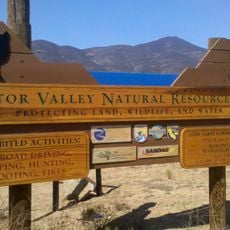
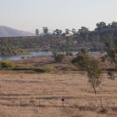
The bridge marks the entrance to San Diego National Wildlife Refuge, connecting visitors to protected habitats for endangered species and native California plants. Local nature observers and hikers use it as a vantage point to watch birds and wildlife in their natural setting.

The bridge is accessible from Singer Lane, which branches off Highway 94, where a small parking area serves hikers and photographers. The location is straightforward to reach and works well as a stopping point for a walk or short hike along the riverbed.

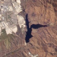
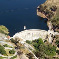
The structure stands isolated without connection to active roads, occasionally spanning a riverbed that runs completely dry during summer months. This detachment gives it a haunting quality, as if it were a monument from another era now existing only for visitors and the natural world.

Location: California

GPS coordinates: 32.73316,-116.94064

Latest update: December 14, 2025 18:20

Photos
Around this place
Cowles Mountain
United States of America

Cowles Mountain

12.3 km
Skyline Church
United States of America

Skyline Church

1.4 km
Lake Murray
United States of America

Lake Murray

11.3 km
Aztec Bowl
United States of America

Aztec Bowl

13.1 km
Lower Otay Reservoir
United States of America

Lower Otay Reservoir

12 km
Sweetwater Dam
United States of America

Sweetwater Dam

7.8 km
San Miguel Mountain
United States of America

San Miguel Mountain

4.1 km
Hepner Hall
United States of America

Hepner Hall

13.1 km
Museum of Creation and Earth History
United States of America

Museum of Creation and Earth History

12.6 km
Sweetwater Reservoir
United States of America

Sweetwater Reservoir

5.9 km
Hardy Memorial Tower
United States of America

Hardy Memorial Tower

13.1 km
Hubert H. Bancroft Ranch House
United States of America

Hubert H. Bancroft Ranch House

4.5 km
Edgemoor Farm Dairy Barn
United States of America

Edgemoor Farm Dairy Barn

12.6 km
Aztec Student Union
United States of America

Aztec Student Union

12.9 km
McGinty Mountain
United States of America

McGinty Mountain

7.8 km
Christian Fellowship Congregational Church
United States of America

Christian Fellowship Congregational Church

12.6 km
Creation & Earth History Museum & Bookstore
United States of America

Creation & Earth History Museum & Bookstore

12.6 km
Jardín Ahorrador de Agua en el Cuyamaca College
United States of America

Jardín Ahorrador de Agua en el Cuyamaca College

1.3 km
San Diego State College
United States of America

San Diego State College

13.1 km
Cal Coast Credit Union Open Air Theatre
United States of America

Cal Coast Credit Union Open Air Theatre

13.1 km
South Bay Botanic Gardens
United States of America

South Bay Botanic Gardens

11.3 km
Museum
United States of America

Museum

1.1 km
Love Library Addition
United States of America

Love Library Addition

13 km
Lemon Grove Park
United States of America

Lemon Grove Park

7.7 km
Administration Building
United States of America

Administration Building

13.1 km
Engineering & Interdisciplinary Sciences Complex
United States of America

Engineering & Interdisciplinary Sciences Complex

13.1 km
La Mesa Library
United States of America

La Mesa Library

8.6 km
Geology, Math and Computer Science Building
United States of America

Geology, Math and Computer Science Building

13 km
Show the full map
Reviews

Visited this place? Tap the stars to rate it and share your experience / photos with the community! Try now! You can cancel it anytime.

« Sweetwater River Bridge - Historic steel bridge in Rancho San Diego, United States » is provided by Around Us (aroundus.com). Images and texts are derived from Wikimedia project under a Creative Commons license. You are allowed to copy, distribute, and modify copies of this page, under the conditions set by the license, as long as this note is clearly visible.

Discover hidden gems everywhere you go!

From secret cafés to breathtaking viewpoints, skip the crowded tourist spots and find places that match your style. Our app makes it easy with voice search, smart filtering, route optimization, and insider tips from travelers worldwide. Download now for the complete mobile experience.

Around Us App Screenshot

A unique approach to discovering new places

Le Figaro

All the places worth exploring

France Info

A tailor-made excursion in just a few clicks

20 Minutes