Chest opened
+${chestReward.xp} XP
Explorer
NOUVEAU ×${chestReward.collectible.quantity}
tapez pour fermer
Chest locked

Open chests in the app

Around Us is built for your phone — chests unlock when you walk, explore and capture nearby places.

Enable Location

We need your location to show you interesting places around you

Discover nearby places

Find interesting locations and hidden gems around you

Precise directions

Get accurate directions and distances to places

Your location is never shared with other users. It's only used when you tap the location button.

Laveen

Log in to your account

Start exploring — it's free

Trusted by 72,881 travelers worldwide

Continue with Google
Continue with Apple
or

We will send you a code to connect

By continuing, you accept our Terms and Conditions and our Privacy Policy

Check your inbox

We've sent a pincode in your inbox. Please enter the code below.

Discussion Reviews 1 Photos
20.9k Popularity

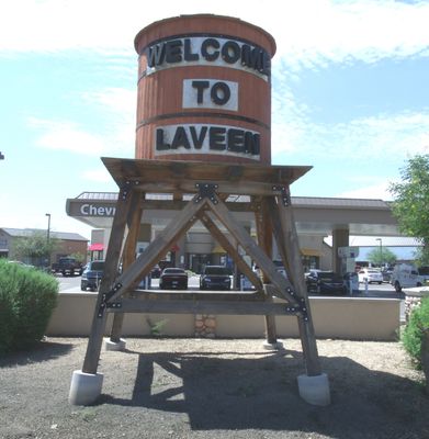
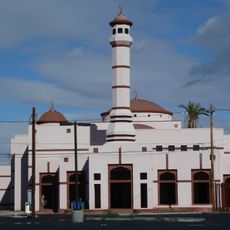
Laveen, human settlement in Phoenix, Arizona, United States

Laveen is an unincorporated community on the southwestern edge of Phoenix, Arizona, where older single-family homes sit alongside newer construction. The streets are wide, lots tend to be generous in size, and several parks are spread across the area.

Laveen started as a farming area on the edge of Phoenix and stayed rural and sparsely settled for most of the 20th century. Growth picked up noticeably in the early 2000s as Phoenix expanded outward and new housing developments moved into the area.

Many families in Laveen keep dogs, and the fenced dog parks serve as natural meeting points where neighbors get to know each other. Around the holidays, front yards and porches across the area fill with decorations that neighbors put up together as a shared tradition.

Getting around Laveen is easiest by car, and parking is generally not a problem anywhere in the area. Visiting early in the morning or in the late afternoon helps avoid the intense heat that Arizona brings for much of the year.

South Mountain Park, one of the largest municipal parks in the country, sits just minutes away and offers dozens of trails through desert terrain. Hikers who arrive at sunrise often find the rocky ridgelines almost entirely to themselves before the midday heat sets in.

The community of curious travelers

AroundUs brings together thousands of curated places, local tips, and hidden gems, enriched daily by 60,000 contributors worldwide.

Start exploring
Location
Elevation above the sea
315 m
GPS coordinates
33.36188,-112.15339
Latest update
March 3, 2026 08:22
Around this place
Arizona State Capitol
United States of America

Arizona State Capitol

11 km
Mystery Castle
United States of America

Mystery Castle

8.5 km
Arizona Federal Theatre
United States of America

Arizona Federal Theatre

11.9 km
South Mountain Park
United States of America

South Mountain Park

8.3 km
Wesley Bolin Memorial Plaza
United States of America

Wesley Bolin Memorial Plaza

11.1 km
Orpheum Theatre
United States of America

Orpheum Theatre

12.1 km
Carver High School
United States of America

Carver High School

11.8 km
Phoenix City Hall
United States of America

Phoenix City Hall

12 km
Sandra Day O'Connor United States Courthouse
United States of America

Sandra Day O'Connor United States Courthouse

11.7 km
Luhrs Tower
United States of America

Luhrs Tower

11.9 km
Islamic Community Center of Phoenix
United States of America

Islamic Community Center of Phoenix

8.8 km
Jain Center of Greater Phoenix
United States of America

Jain Center of Greater Phoenix

5.2 km
9/11 Memorial in Arizona
United States of America

9/11 Memorial in Arizona

11.1 km
Luhrs Building
United States of America

Luhrs Building

12 km
Cartwright Elementary School District
United States of America

Cartwright Elementary School District

13.5 km
Arizona Mining and Mineral Museum
United States of America

Arizona Mining and Mineral Museum

11.2 km
Wells Fargo Plaza
United States of America

Wells Fargo Plaza

12 km
Polly Rosenbaum Building
United States of America

Polly Rosenbaum Building

11.2 km
Phoenix Police Museum
United States of America

Phoenix Police Museum

11.9 km
First Baptist Church
United States of America

First Baptist Church

12.1 km
Wells Fargo History Museum
United States of America

Wells Fargo History Museum

12.1 km
Arizona Capitol Museum
United States of America

Arizona Capitol Museum

10.9 km
Evans House
United States of America

Evans House

11.5 km
Sachs-Webster House
United States of America

Sachs-Webster House

6.4 km
Del Monte Market
United States of America

Del Monte Market

3.3 km
Laveen School Auditorium
United States of America

Laveen School Auditorium

1.4 km
Copeland & Tracht Service Station
United States of America

Copeland & Tracht Service Station

11.4 km
Wells Fargo
United States of America

Wells Fargo

12 km
Show the full map
Reviews
Share your experience

No review yet

Discussions
Start a discussion...

No discussion yet

« Laveen - human settlement in Phoenix, Arizona, United States » is provided by Around Us (aroundus.com). Images and texts are derived from Wikimedia project under a Creative Commons license. You are allowed to copy, distribute, and modify copies of this page, under the conditions set by the license, as long as this note is clearly visible.

Discover hidden gems everywhere you go!

From secret cafés to breathtaking viewpoints, skip the crowded tourist spots and find places that match your style. Our app makes it easy with voice search, smart filtering, route optimization, and insider tips from travelers worldwide. Download now for the complete mobile experience.

Around Us App Screenshot

A unique approach to discovering new places

Le Figaro

All the places worth exploring

France Info

A tailor-made excursion in just a few clicks

20 Minutes

Around Us
Travel Guide & Maps
Download

Send to your phone

QR Code
1

Open the camera app on your mobile.

2

Point at the QR code with your camera. A notification will appear.

3

Tap the notification to open the link.