Chest opened
+${chestReward.xp} XP
Explorer
NOUVEAU ×${chestReward.collectible.quantity}
tapez pour fermer
Chest locked

Open chests in the app

Around Us is built for your phone — chests unlock when you walk, explore and capture nearby places.

Enable Location

We need your location to show you interesting places around you

Discover nearby places

Find interesting locations and hidden gems around you

Precise directions

Get accurate directions and distances to places

Your location is never shared with other users. It's only used when you tap the location button.

Sierra Estrella

Log in to your account

Start exploring — it's free

Trusted by 72,886 travelers worldwide

Continue with Google
Continue with Apple
or

We will send you a code to connect

By continuing, you accept our Terms and Conditions and our Privacy Policy

Check your inbox

We've sent a pincode in your inbox. Please enter the code below.

Sierra Estrella
Discussion Reviews 1 Photos
10.7k Popularity

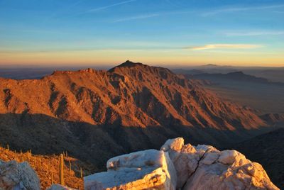
Sierra Estrella, Mountain range in Pinal County, Arizona

Sierra Estrella is a mountain range in Pinal County, Arizona, characterized by steep slopes and sharp, jagged ridgelines. The landscape contains numerous rocky canyons with peaks reaching approximately 4,500 feet in elevation.

The Battle of Pima Butte occurred near the range in 1857, marking a significant military clash between regional groups. This conflict shaped the dynamics of the area during that period.

Ancient rock carvings in the southern section show that Akimel O'odham and Yavapai peoples lived here for centuries. Visitors walking through these areas can still see the marks they left on the stone.

Access to the area requires careful planning and knowledge of local conditions due to the challenging terrain. Most of the wilderness is difficult to reach, so visitors should research permitted areas before visiting.

The range supports multiple animal species that thrive at different elevations, each occupying distinct ecological zones. Desert bighorn sheep, mountain lions, and golden eagles each inhabit different levels of this landscape.

The community of curious travelers

AroundUs brings together thousands of curated places, local tips, and hidden gems, enriched daily by 60,000 contributors worldwide.

Start exploring
Location
GPS coordinates
33.27361,-112.28083
Latest update
December 10, 2025 15:52
Around this place
Phoenix Raceway
United States of America

Phoenix Raceway

11.6 km
Mystery Castle
United States of America

Mystery Castle

22.4 km
Arizona Federal Theatre
United States of America

Arizona Federal Theatre

27 km
Desert Sky Pavilion
United States of America

Desert Sky Pavilion

22.5 km
South Mountain Park
United States of America

South Mountain Park

20.9 km
Wesley Bolin Memorial Plaza
United States of America

Wesley Bolin Memorial Plaza

26.1 km
Carver High School
United States of America

Carver High School

27.1 km
Phoenix City Hall
United States of America

Phoenix City Hall

27.2 km
Sandra Day O'Connor United States Courthouse
United States of America

Sandra Day O'Connor United States Courthouse

26.9 km
Luhrs Tower
United States of America

Luhrs Tower

27.2 km
Islamic Community Center of Phoenix
United States of America

Islamic Community Center of Phoenix

24.1 km
Jain Center of Greater Phoenix
United States of America

Jain Center of Greater Phoenix

20.6 km
9/11 Memorial in Arizona
United States of America

9/11 Memorial in Arizona

26.1 km
Cartwright Elementary School District
United States of America

Cartwright Elementary School District

24.6 km
Arizona Mining and Mineral Museum
United States of America

Arizona Mining and Mineral Museum

26.2 km
House of the Future
United States of America

House of the Future

26.7 km
Wells Fargo Plaza
United States of America

Wells Fargo Plaza

27.2 km
Polly Rosenbaum Building
United States of America

Polly Rosenbaum Building

26.2 km
Phoenix Police Museum
United States of America

Phoenix Police Museum

27.2 km
Arizona Capitol Museum
United States of America

Arizona Capitol Museum

25.9 km
Evans House
United States of America

Evans House

26.6 km
Dunbar School
United States of America

Dunbar School

26 km
Sachs-Webster House
United States of America

Sachs-Webster House

12.7 km
Del Monte Market
United States of America

Del Monte Market

18.1 km
Urban Air Trampoline and Adventure Park
United States of America

Urban Air Trampoline and Adventure Park

23.3 km
Laveen School Auditorium
United States of America

Laveen School Auditorium

14.4 km
Wigwam Resort
United States of America

Wigwam Resort

26.2 km
Sonic
United States of America

Sonic

24.6 km
Show the full map
Reviews
Share your experience

No review yet

Discussions
Start a discussion...

No discussion yet

« Sierra Estrella - Mountain range in Pinal County, Arizona » is provided by Around Us (aroundus.com). Images and texts are derived from Wikimedia project under a Creative Commons license. You are allowed to copy, distribute, and modify copies of this page, under the conditions set by the license, as long as this note is clearly visible.

Discover hidden gems everywhere you go!

From secret cafés to breathtaking viewpoints, skip the crowded tourist spots and find places that match your style. Our app makes it easy with voice search, smart filtering, route optimization, and insider tips from travelers worldwide. Download now for the complete mobile experience.

Around Us App Screenshot

A unique approach to discovering new places

Le Figaro

All the places worth exploring

France Info

A tailor-made excursion in just a few clicks

20 Minutes

Around Us
Travel Guide & Maps
Download

Send to your phone

QR Code
1

Open the camera app on your mobile.

2

Point at the QR code with your camera. A notification will appear.

3

Tap the notification to open the link.