Chest opened
+${chestReward.xp} XP
Explorer
NOUVEAU ×${chestReward.collectible.quantity}
tapez pour fermer
Chest locked

Open chests in the app

Around Us is built for your phone — chests unlock when you walk, explore and capture nearby places.

Enable Location

We need your location to show you interesting places around you

Discover nearby places

Find interesting locations and hidden gems around you

Precise directions

Get accurate directions and distances to places

Your location is never shared with other users. It's only used when you tap the location button.

Log in to your account

Start exploring — it's free

Trusted by 73,002 travelers worldwide

Continue with Google
Continue with Apple
or

We will send you a code to connect

By continuing, you accept our Terms and Conditions and our Privacy Policy

Check your inbox

We've sent a pincode in your inbox. Please enter the code below.

Hayden-Rhodes Aqueduct
Discussion Reviews Photo
1.7k Popularity

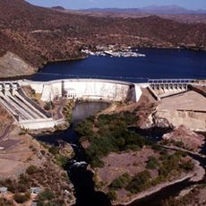
Hayden-Rhodes Aqueduct, Water diversion canal in Arizona, United States.

The Hayden-Rhodes Aqueduct is a water transport system that carries water from the Colorado River across Arizona using channels, pipes, and tunnels. Pumping stations along the route move the water over hills and mountains to reach cities and farmland across the state.

Construction began in the 1970s to address the growing water needs of Arizona's expanding population and economy. The project was shaped by earlier agreements about sharing water from the Colorado River among southwestern states.

The aqueduct has shaped how communities in Arizona depend on water from distant sources, becoming part of the landscape that residents see and use every day. It enabled agricultural expansion and urban growth that changed how people live and work across the region.

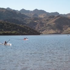
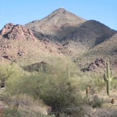
The aqueduct runs across diverse terrain ranging from desert flatlands to mountainous areas, so the experience changes depending on where you visit. Early morning or late afternoon visits offer better light for viewing and photography along accessible sections.

The system requires enormous amounts of electricity year-round to pump water uphill through the landscape, which few visitors realize when they first encounter it. This energy demand is so large that it ranks among the biggest power consumers in the entire state.

The community of curious travelers

AroundUs brings together thousands of curated places, local tips, and hidden gems, enriched daily by 60,000 contributors worldwide.

Start exploring
Location
GPS coordinates
33.52926,-111.70440
Latest update
December 14, 2025 12:22
Around this place
Taliesin West
United States of America

Taliesin West

15.6 km
Salt River Fields at Talking Stick
United States of America

Salt River Fields at Talking Stick

16.9 km
OdySea Aquarium
United States of America

OdySea Aquarium

16.3 km
HoHoKam Stadium
United States of America

HoHoKam Stadium

15.5 km
Saguaro Lake
United States of America

Saguaro Lake

17.2 km
Mesa Grande
United States of America

Mesa Grande

16.8 km
Mesa Arts Center
United States of America

Mesa Arts Center

17.3 km
Butterfly Wonderland

Butterfly Wonderland

16.2 km
United States of America

Mount McDowell

1.6 km
Arizona Commemorative Air Force Museum
United States of America

Arizona Commemorative Air Force Museum

9 km
Buckhorn Baths Motel
United States of America

Buckhorn Baths Motel

12.6 km
Stewart Mountain Dam
United States of America

Stewart Mountain Dam

16.2 km
Thompson Peak
United States of America

Thompson Peak

16.2 km
Mesa Historical Museum
United States of America

Mesa Historical Museum

12.8 km
United States of America

Buckhorn Hot Mineral Wells

12.5 km
Mesa East Bowl
United States of America

Mesa East Bowl

15 km
West Second Street Historic District
United States of America

West Second Street Historic District

17.1 km
Fountain Hills Observatory
United States of America

Fountain Hills Observatory

12.3 km
Las Sendas Golf Club
United States of America

Las Sendas Golf Club

6.2 km
Wilbur Street Historic District
United States of America

Wilbur Street Historic District

16.7 km
Mesa Aquatic Complex
United States of America

Mesa Aquatic Complex

17.3 km
Kino Aquatic Center
United States of America

Kino Aquatic Center

14.9 km
Desert Sands Golf Course
United States of America

Desert Sands Golf Course

16.6 km
Original ChopShop
United States of America

Original ChopShop

17.1 km
Brimhall Aquatic Complex
United States of America

Brimhall Aquatic Complex

15.3 km
Stapley Aquatic Center
United States of America

Stapley Aquatic Center

9.2 km
Desert Canyon Golf Course
United States of America

Desert Canyon Golf Course

6.3 km
Falcon Field Airport
United States of America

Falcon Field Airport

8.3 km
Show the full map
Reviews
Share your experience

No review yet

Discussions
Start a discussion...

No discussion yet

« Hayden-Rhodes Aqueduct - Water diversion canal in Arizona, United States » is provided by Around Us (aroundus.com). Images and texts are derived from Wikimedia project under a Creative Commons license. You are allowed to copy, distribute, and modify copies of this page, under the conditions set by the license, as long as this note is clearly visible.

Discover hidden gems everywhere you go!

From secret cafés to breathtaking viewpoints, skip the crowded tourist spots and find places that match your style. Our app makes it easy with voice search, smart filtering, route optimization, and insider tips from travelers worldwide. Download now for the complete mobile experience.

Around Us App Screenshot

A unique approach to discovering new places

Le Figaro

All the places worth exploring

France Info

A tailor-made excursion in just a few clicks

20 Minutes

Around Us
Travel Guide & Maps
Download

Send to your phone

QR Code
1

Open the camera app on your mobile.

2

Point at the QR code with your camera. A notification will appear.

3

Tap the notification to open the link.