·

Enable Location

We need your location to show you interesting places around you

Discover nearby places

Find interesting locations and hidden gems around you

Precise directions

Get accurate directions and distances to places

Your location is never shared with other users. It's only used when you tap the location button.

Thompson Peak

Log in to your account

Start exploring — it's free

Trusted by 62,732 travelers worldwide

Continue with Google
Continue with Apple
or

We will send you a code to connect

By continuing, you accept our Terms and Conditions and our Privacy Policy

Check your inbox

We've sent a pincode in your inbox. Please enter the code below.

Thompson Peak

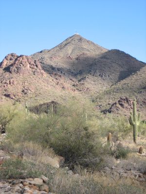
Thompson Peak, Mountain summit in McDowell Mountains, Maricopa County, Arizona

Thompson Peak rises to 3,984 feet within the McDowell Mountains, featuring communication towers at its summit and offering panoramic views across the Valley of the Sun through challenging terrain that climbs nearly 2,000 feet from base to peak.

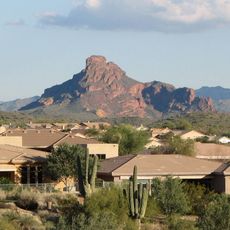
The summit has served as a significant landmark for generations, with its strategic position in the McDowell Mountains making it a natural reference point for early settlers and indigenous peoples navigating the desert landscape of central Arizona.

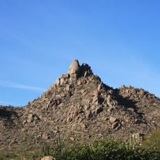
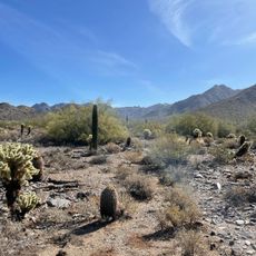
Thompson Peak attracts outdoor enthusiasts from Phoenix and Scottsdale who seek challenging hikes through Sonoran Desert terrain populated with towering saguaro cacti, creating a popular destination for the regional hiking and trail running community.

The main hiking route spans approximately 9.5 miles roundtrip with 2,572 feet of elevation gain, requiring 4-5 hours to complete and accessed via the Golden Eagle Trailhead near Fountain Hills with parking and restroom facilities available.

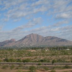
Thompson Peak ranks as the third highest summit among fifteen peaks within the McDowell Sonoran Preserve, with a prominence of 787 feet that makes it distinctly visible from surrounding desert plains and urban areas.

The community of curious travelers

AroundUs brings together thousands of curated places, local tips, and hidden gems, enriched daily by 60,000 contributors worldwide.

Start exploring
Location
GPS coordinates
33.64421,-111.81209
Latest update
July 25, 2025 19:52
Around this place
Taliesin West
United States of America

Taliesin West

5.2 km
Camelback Mountain
United States of America

Camelback Mountain

20 km
Salt River Fields at Talking Stick
United States of America

Salt River Fields at Talking Stick

12.9 km
Musical Instrument Museum
United States of America

Musical Instrument Museum

15.6 km
OdySea Aquarium
United States of America

OdySea Aquarium

11.7 km
McCormick Stillman Railroad Park
United States of America

McCormick Stillman Railroad Park

15.8 km
Pinnacle Peak
United States of America

Pinnacle Peak

10.5 km
Butterfly Wonderland

Butterfly Wonderland

11.6 km
Mummy Mountain
United States of America

Mummy Mountain

17.9 km
McCormick-Stillman Railroad Park
United States of America

McCormick-Stillman Railroad Park

15.8 km
United States of America

Mount McDowell

15.9 km

Scottsdale Museum of Contemporary Art
United States of America

Scottsdale Museum of Contemporary Art

19.9 km
Congregation Beth Israel
United States of America

Congregation Beth Israel

16.9 km
Roald Amundsen
United States of America

Roald Amundsen

15.7 km
Gateway Trailhead - McDowell Sonoran Preserve

Gateway Trailhead - McDowell Sonoran Preserve

4.3 km
Pinnacle Peak Park
United States of America

Pinnacle Peak Park

10.4 km
Little Red Schoolhouse
United States of America

Little Red Schoolhouse

19.8 km
Louise Lincoln Kerr House and Studio
United States of America

Louise Lincoln Kerr House and Studio

16.9 km
Udinotti Museum of Figurative Art
United States of America

Udinotti Museum of Figurative Art

17.9 km
Edward L. Jones House
United States of America

Edward L. Jones House

18.4 km
Fountain Hills Observatory
United States of America

Fountain Hills Observatory

6.7 km
Scottsdale Shadows Executive Golf Course
United States of America

Scottsdale Shadows Executive Golf Course

18.1 km
Verde River Golf and Social Club
United States of America

Verde River Golf and Social Club

15.7 km
Desert Canyon Golf Course
United States of America

Desert Canyon Golf Course

11.2 km
Scottsdale Historical Museum
United States of America

Scottsdale Historical Museum

19.8 km
Gilbert Ortega
United States of America

Gilbert Ortega

19.4 km
Monterra at WestWorld
United States of America

Monterra at WestWorld

6.9 km
Show the full map
« Thompson Peak - Mountain summit in McDowell Mountains, Maricopa County, Arizona » is provided by Around Us (aroundus.com). Images and texts are derived from Wikimedia project under a Creative Commons license. You are allowed to copy, distribute, and modify copies of this page, under the conditions set by the license, as long as this note is clearly visible.

Discover hidden gems everywhere you go!

From secret cafés to breathtaking viewpoints, skip the crowded tourist spots and find places that match your style. Our app makes it easy with voice search, smart filtering, route optimization, and insider tips from travelers worldwide. Download now for the complete mobile experience.

Around Us App Screenshot

A unique approach to discovering new places

Le Figaro

All the places worth exploring

France Info

A tailor-made excursion in just a few clicks

20 Minutes

Around Us
Travel Guide & Maps
Download

Send to your phone

QR Code
1

Open the camera app on your mobile.

2

Point at the QR code with your camera. A notification will appear.

3

Tap the notification to open the link.