Chest opened
+${chestReward.xp} XP
Explorer
NOUVEAU ×${chestReward.collectible.quantity}
tapez pour fermer
Chest locked

Open chests in the app

Around Us is built for your phone — chests unlock when you walk, explore and capture nearby places.

Enable Location

We need your location to show you interesting places around you

Discover nearby places

Find interesting locations and hidden gems around you

Precise directions

Get accurate directions and distances to places

Your location is never shared with other users. It's only used when you tap the location button.

Naco

Log in to your account

Start exploring — it's free

Trusted by 72,883 travelers worldwide

Continue with Google
Continue with Apple
or

We will send you a code to connect

By continuing, you accept our Terms and Conditions and our Privacy Policy

Check your inbox

We've sent a pincode in your inbox. Please enter the code below.

Naco
Discussion Reviews 1 Photos
12.8k Popularity

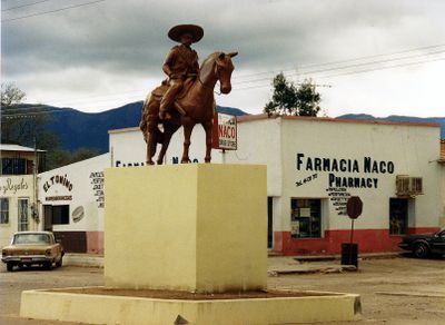
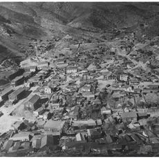
Naco, Border municipality in Sonora, Mexico.

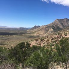
Naco is a border municipality in Sonora situated at 1408 meters elevation and connecting the Mexican state with its counterpart town across the border in Arizona. The settlement is located in a highland region where the landscape transitions between the two countries.

The settlement began in 1901 when a railway line to Cananea was built to support copper mining operations near the border. This rail connection became central to the area's economic development and growth.

The name Naco comes from the Opata language and refers to the prickly pear cactus that grows naturally throughout the region and shapes the landscape. These plants remain a visible part of the local environment and connect the place to its indigenous roots.

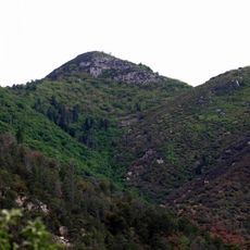
The settlement is accessible through a border crossing that connects to the neighboring Arizona town. Visitors should note that the terrain is hilly and the border location requires standard attention when crossing.

A fleeting moment in 1929 saw an aviator accidentally bomb the United States side during a rebellion while attempting to support Mexican rebels. This unusual incident remains a surprising part of the local story.

The community of curious travelers

AroundUs brings together thousands of curated places, local tips, and hidden gems, enriched daily by 60,000 contributors worldwide.

Start exploring
Location
Inception
1901
GPS coordinates
31.33167,-109.94806
Latest update
December 7, 2025 20:43
Around this place
Coronado National Memorial
United States of America

Coronado National Memorial

30.9 km
Miller Peak
United States of America

Miller Peak

33.5 km
United States of America

Lehner Mammoth-Kill Site

18.3 km
San Pedro Riparian National Conservation Area
United States of America

San Pedro Riparian National Conservation Area

32.9 km
United States of America

Junk Bond Observatory

29.1 km
United States of America

Arizona Cactus Botanical Garden

7.2 km
Bisbee Historic District
United States of America

Bisbee Historic District

12.8 km
Hereford Arizona Observatory
United States of America

Hereford Arizona Observatory

30.6 km
Phelps Dodge General Office Building
United States of America

Phelps Dodge General Office Building

12.7 km
St. Patrick's Roman Catholic Church
United States of America

St. Patrick's Roman Catholic Church

12.8 km
Coronado cave
United States of America

Coronado cave

29.8 km
Bisbee Residential Historic District
United States of America

Bisbee Residential Historic District

12.7 km
Bisbee Woman's Club Clubhouse
United States of America

Bisbee Woman's Club Clubhouse

12.4 km
Kinjockity Ranch
United States of America

Kinjockity Ranch

26.7 km
United States of America

Palominas Observatory

23.8 km
United States of America

Castle Rock

12.6 km
United States of America

Coronado National Memorial Visitor Center

29.1 km
United States of America

Bucky O'Neill Hill

12.3 km
Castle Rock
United States of America

Castle Rock

12.6 km
Mexico

Cañón Mina Oro

10.2 km
Evergreen Cemetery
United States of America

Evergreen Cemetery

12.4 km
United States of America

Turquoise Valley Golf Course

1.4 km
United States of America

Car

13.5 km
United States of America

Car

12.7 km
United States of America

Iron Man

12.7 km
United States of America

Coronado Memorial Overlook

32 km
United States of America

Scenic viewpoint

33.3 km
United States of America

Montezuma Pass Viewpoint

32.1 km
Show the full map
Reviews
Share your experience

No review yet

Discussions
Start a discussion...

No discussion yet

« Naco - Border municipality in Sonora, Mexico » is provided by Around Us (aroundus.com). Images and texts are derived from Wikimedia project under a Creative Commons license. You are allowed to copy, distribute, and modify copies of this page, under the conditions set by the license, as long as this note is clearly visible.

Discover hidden gems everywhere you go!

From secret cafés to breathtaking viewpoints, skip the crowded tourist spots and find places that match your style. Our app makes it easy with voice search, smart filtering, route optimization, and insider tips from travelers worldwide. Download now for the complete mobile experience.

Around Us App Screenshot

A unique approach to discovering new places

Le Figaro

All the places worth exploring

France Info

A tailor-made excursion in just a few clicks

20 Minutes

Around Us
Travel Guide & Maps
Download

Send to your phone

QR Code
1

Open the camera app on your mobile.

2

Point at the QR code with your camera. A notification will appear.

3

Tap the notification to open the link.