Enable Location

We need your location to show you interesting places around you

Discover nearby places

Find interesting locations and hidden gems around you

Precise directions

Get accurate directions and distances to places

Your location is never shared with other users. It's only used when you tap the location button.

Coronado National Memorial

Log in to your account

Join the adventure

Create your free account and start exploring (like 60k+ others)

We will send you a code to connect

or
Continue with Google
Continue with Apple
By continuing, you accept our Terms and Conditions and our Privacy Policy

Check your inbox

We've sent a pincode in your inbox. Please enter the code below.

Coronado National Memorial, National Memorial in Cochise County, Arizona, US

Description

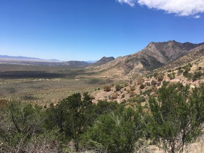
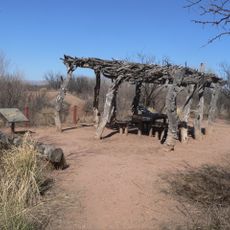
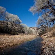
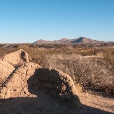
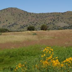
Coronado National Memorial is a protected site in the Huachuca Mountains spanning several thousand acres with trails of varying difficulty. From higher points on the property, visitors can see both the United States and Mexico while taking in mountain views.

History

The expedition led by Spanish conquistador Coronado passed through this area in 1540 while searching for legendary wealthy cities. This journey represented one of the first contacts between European and local cultures in what is now Arizona.

Culture

The site is named after the Spanish explorer Coronado and marks where different peoples and worlds encountered each other across this border region. Walking through the landscape helps visitors understand the impact of these early contacts on the region.

Practical

The site is accessible year-round with various trails ranging from short to longer routes. Visitors should prepare for temperature shifts since the mountains can be noticeably cooler or warmer than lower surrounding areas depending on season and elevation.

Did you know?

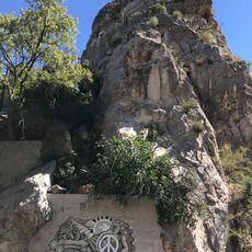
A striking rock outcrop at the highest point sits right at the border between the two countries and displays inscriptions from visitors across different time periods. This natural formation has served as a landmark for travelers crossing this border route for centuries.

Location
Inception
November 5, 1952
Operator
National Park Service
Address
East Montezuma Canyon Road
Phone
GPS coordinates
31.34830,-110.27200
Latest update
December 8, 2025 20:02

AroundUs brings together thousands of curated places, local tips, and hidden gems, enriched daily by 60,000 contributors worldwide. Discover all places nearby (Cochise County).

Around this place
Bird Cage Theatre
United States of America

Bird Cage Theatre

45 km
San Rafael Ranch
United States of America

San Rafael Ranch

32.4 km
Miller Peak
United States of America

Miller Peak

5.3 km
Schieffelin Hall
United States of America

Schieffelin Hall

45.1 km
Tombstone Courthouse
United States of America

Tombstone Courthouse

44.9 km
Murray Springs Clovis Site
United States of America

Murray Springs Clovis Site

26.3 km
San Pedro Riparian National Conservation Area
United States of America

San Pedro Riparian National Conservation Area

29.3 km
Tombstone Historic District
United States of America

Tombstone Historic District

45 km
Presidio Santa Cruz de Terrenate
United States of America

Presidio Santa Cruz de Terrenate

45.2 km
Brown Canyon Ranch
United States of America

Brown Canyon Ranch

14.2 km
Bisbee Historic District
United States of America

Bisbee Historic District

35.6 km
The Little Outfit Schoolhouse
United States of America

The Little Outfit Schoolhouse

33 km
Hereford Arizona Observatory
United States of America

Hereford Arizona Observatory

12 km
Canelo Hills Cienega Reserve
United States of America

Canelo Hills Cienega Reserve

33.9 km
Phelps Dodge General Office Building
United States of America

Phelps Dodge General Office Building

35.5 km
St. Patrick's Roman Catholic Church
United States of America

St. Patrick's Roman Catholic Church

34.9 km
Canelo School
United States of America

Canelo School

31.3 km
Canelo Ranger Station
United States of America

Canelo Ranger Station

32.4 km
James Finley House
United States of America

James Finley House

43.2 km
Coronado cave
United States of America

Coronado cave

1.1 km
Parroquia de Guadalupe en Cananea Sonora
Mexico

Parroquia de Guadalupe en Cananea Sonora

40.9 km
Plaza Juárez
Mexico

Plaza Juárez

40.7 km
Bisbee Residential Historic District
United States of America

Bisbee Residential Historic District

34.7 km
Bisbee Woman's Club Clubhouse
United States of America

Bisbee Woman's Club Clubhouse

35.3 km
Cananea city hall
Mexico

Cananea city hall

40.7 km
Kinjockity Ranch
United States of America

Kinjockity Ranch

6.4 km
Castle Rock
United States of America

Castle Rock

35.2 km
Hereford Road Bridge
United States of America

Hereford Road Bridge

18.5 km
Show the full map
« Coronado National Memorial - National Memorial in Cochise County, Arizona, US » is provided by Around Us (aroundus.com). Images and texts are derived from Wikimedia project under a Creative Commons license. You are allowed to copy, distribute, and modify copies of this page, under the conditions set by the license, as long as this note is clearly visible.

Discover hidden gems everywhere you go!

From secret cafés to breathtaking viewpoints, skip the crowded tourist spots and find places that match your style. Our app makes it easy with voice search, smart filtering, route optimization, and insider tips from travelers worldwide. Download now for the complete mobile experience.

Around Us App Screenshot

A unique approach to discovering new places

Le Figaro

All the places worth exploring

France Info

A tailor-made excursion in just a few clicks

20 Minutes

Around Us
Travel Guide & Maps
Download

Send to your phone

QR Code
1

Open the camera app on your mobile.

2

Point at the QR code with your camera. A notification will appear.

3

Tap the notification to open the link.