Ruby

Log in to your account

AroundUs is a community-driven map of interesting places, built by curious explorers like you. It grows with every review, story, and photo you share.
Connect to save your favorite spots, contribute locations, and create personalized routes.
Continue with Google
Continue with Apple
Continue with X
Continue with Facebook
Continue with email
By continuing, you accept our Terms and Conditions and our Privacy Policy
Create an account
Add to collection
Map
Suggest a change
Share

Ruby, ghost town in Santa Cruz County, Arizona

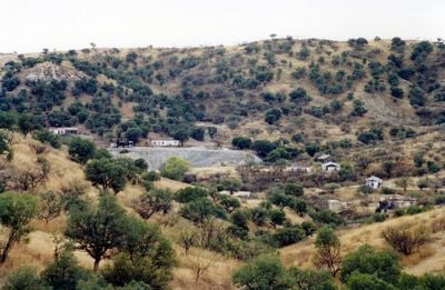
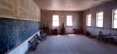
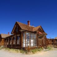
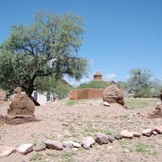
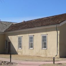
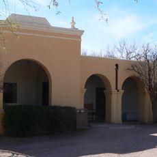
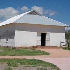
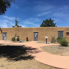
Ruby is a ghost town in the mountains of Santa Cruz County, Arizona, with about 25 remaining buildings including a jail, schoolhouse, houses, and old mining equipment from former lead and zinc operations. The structures and mine workings tell the story of a past mining community built on the slopes near Montana Peak.

Ruby began around 1877 as Montana Camp, a mining settlement extracting lead, zinc, silver, and gold from the Montana mine, which became the town's economic core. The post office opened in 1910 under the name Ruby, the town peaked in the 1930s with around 1,200 residents, then declined after mining ceased in 1940.

The town took its name from the wife of postmaster Julius Andrews, whose maiden name was given to the post office in 1910. The place reflects how mining communities organized around a general store and public buildings that served as centers of daily life for workers and their families.

Access to Ruby is limited since it is private property; visitors must obtain a permit online before entering the site. The gate opens Thursday through Sunday for those who wish to explore the remaining buildings and grounds on their own.

Each evening at sunset, thousands of Mexican free-tailed bats emerge from an old mine shaft and sweep over the town in waves; this natural display draws many visitors. The phenomenon makes Ruby a rare place where mining history and active wildlife converge in one location.

Location: Santa Cruz County

Elevation above the sea: 1,276 m

GPS coordinates: 31.46111,-111.23750

Latest update: December 18, 2025 19:00

Photos
The 100 notable ghost towns in the United States

The United States have hundreds of abandoned towns. This selection includes 100 of these places where time seems to stand still. Most grew rich in the 19th century through gold or silver finds. They attracted miners, traders, and whole families. When the veins were empty, people left. They left...

Around this place
Tumacácori National Historical Park
United States of America

Tumacácori National Historical Park

21.3 km
Tumacácori Mission
United States of America

Tumacácori Mission

21.4 km
Tubac Presidio State Historic Park
United States of America

Tubac Presidio State Historic Park

24.7 km
Tubac Presidio
United States of America

Tubac Presidio

24.7 km
United States of America

Arivaca Lake

7.8 km
Arivaca Schoolhouse
United States of America

Arivaca Schoolhouse

15.5 km
United States of America

Pajarita Wilderness

8.1 km
Old Tubac Schoolhouse
United States of America

Old Tubac Schoolhouse

24.7 km
Tubac Presidio State Historic Park
United States of America

Tubac Presidio State Historic Park

24.6 km
Tumacácori Museum
United States of America

Tumacácori Museum

21.3 km
United States of America

Atascosa Lookout House

9.7 km
United States of America

Caralampi Canyon

23.4 km
United States of America

Tumacacori Peak

19 km
United States of America

Tumacácori National Historical Park Residence No. 2

21.4 km
Otero Hall
United States of America

Otero Hall

24.7 km
United States of America

Tumacácori National Historical Park Residence No. 1

21.4 km
United States of America

Javelin Canyon

13 km
United States of America

Calabasas Canyon

23.9 km
Rojas House
United States of America

Rojas House

24.7 km
United States of America

Aliso Canyon

23.4 km
United States of America

Josephine Canyon

21.9 km
United States of America

Fresno Canyon

14.6 km
United States of America

Cerro Pelon

23.1 km
United States of America

Crusher

19 km
United States of America

Cienega Trail, Buenos Aires NWR

15.1 km
United States of America

Bat viewing benches

208 m
United States of America

Garcia Ranch

21.4 km
United States of America

Scenic viewpoint

24.8 km
Show the full map
Reviews

Visited this place? Tap the stars to rate it and share your experience / photos with the community! Try now! You can cancel it anytime.

« Ruby - ghost town in Santa Cruz County, Arizona » is provided by Around Us (aroundus.com). Images and texts are derived from Wikimedia project under a Creative Commons license. You are allowed to copy, distribute, and modify copies of this page, under the conditions set by the license, as long as this note is clearly visible.

Discover hidden gems everywhere you go!

From secret cafés to breathtaking viewpoints, skip the crowded tourist spots and find places that match your style. Our app makes it easy with voice search, smart filtering, route optimization, and insider tips from travelers worldwide. Download now for the complete mobile experience.

Around Us App Screenshot

A unique approach to discovering new places

Le Figaro

All the places worth exploring

France Info

A tailor-made excursion in just a few clicks

20 Minutes