Enable Location

We need your location to show you interesting places around you

Discover nearby places

Find interesting locations and hidden gems around you

Precise directions

Get accurate directions and distances to places

Your location is never shared with other users. It's only used when you tap the location button.

Lowell Ranger Station

Log in to your account

Join the adventure

Create your free account and start exploring (like 60k+ others)

We will send you a code to connect

or
Continue with Google
Continue with Apple
By continuing, you accept our Terms and Conditions and our Privacy Policy

Check your inbox

We've sent a pincode in your inbox. Please enter the code below.

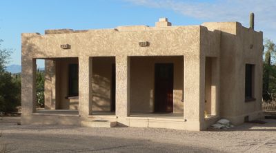
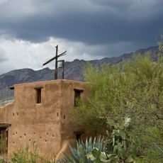
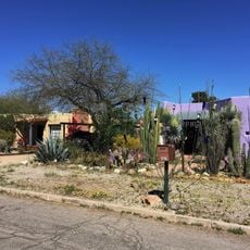
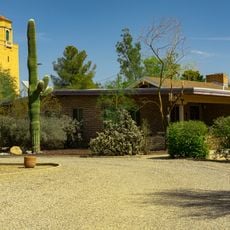
Lowell Ranger Station, Forest Service ranger station in Pima County, United States.

Description

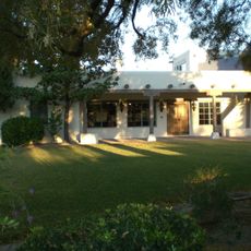
Lowell Ranger Station comprises three buildings - an office, a barn, and a house - spread across two acres in Arizona. All structures follow Pueblo Revival style and appear as a small, self-contained work complex from the mid-20th century.

History

The station was built in 1934 by the Civilian Conservation Corps, a work program during the Great Depression under President Roosevelt. The project was part of New Deal policy to create jobs while protecting forests.

Culture

The station shows how forest work was organized decades ago and how the government managed the land. The buildings and their layout tell the story of this working approach, still visible today.

Practical

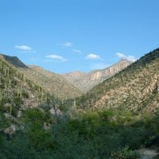
The site is located in a rural area and is best reached by car, as public transit is limited. It is worth checking ahead whether buildings are open to visitors, as access can vary depending on current operations.

Did you know?

The buildings were constructed using a standard plan developed by regional government architects, showing how the government designed buildings uniformly in the 1930s. The Pueblo Revival details are typical of federal buildings from this era in the Southwest and were not custom choices.

Location
Inception
1930s
Architectural style
Pueblo Revival Style architecture
GPS coordinates
32.31103,-110.81816
Latest update
December 14, 2025 18:15

AroundUs brings together thousands of curated places, local tips, and hidden gems, enriched daily by 60,000 contributors worldwide. Discover all places nearby (Pima County).

Around this place
Sabino Canyon
United States of America

Sabino Canyon

640 m
Mount Lemmon Observatory
United States of America

Mount Lemmon Observatory

14.8 km
Tucson Botanical Gardens
United States of America

Tucson Botanical Gardens

14.2 km
DeGrazia Gallery in the Sun Historic District
United States of America

DeGrazia Gallery in the Sun Historic District

7 km
Tucson Arizona Temple
United States of America

Tucson Arizona Temple

12.7 km
Loft Cinema
United States of America

Loft Cinema

12.9 km
United States of America

Bear Canyon

3 km
United States of America

Pima Canyon

14.8 km
University of Arizona Poetry Center
United States of America

University of Arizona Poetry Center

14.8 km
Catalina Station
United States of America

Catalina Station

14.2 km
Agua Caliente Regional Park
United States of America

Agua Caliente Regional Park

8.6 km
Thimble Peak
United States of America

Thimble Peak

5.1 km
Molino Canyon
United States of America

Molino Canyon

11.3 km
Pusch Ridge Wilderness Area
United States of America

Pusch Ridge Wilderness Area

7.4 km
St. Philip's in the Hills Episcopal Church
United States of America

St. Philip's in the Hills Episcopal Church

12 km
The Mini Time Machine Museum
United States of America

The Mini Time Machine Museum

8.9 km
Ball-Paylore House
United States of America

Ball-Paylore House

13.5 km
Catalina American Baptist Church
United States of America

Catalina American Baptist Church

12.4 km
Blenman-Elm Historic District
United States of America

Blenman-Elm Historic District

13.1 km
Lemmon Rock Lookout House
United States of America

Lemmon Rock Lookout House

14.1 km
Colonia Solana Residential Historic District
United States of America

Colonia Solana Residential Historic District

14.3 km
Jefferson Park Historic District
United States of America

Jefferson Park Historic District

14.5 km
Saint Joseph church in Tucson
United States of America

Saint Joseph church in Tucson

11.9 km
Saint Cyril of Alexandria church in Tucson
United States of America

Saint Cyril of Alexandria church in Tucson

10.6 km
Saints-Peter-and-Paul church of Tucson
United States of America

Saints-Peter-and-Paul church of Tucson

14.4 km
Church of Saint Thomas the Apostle in Tucson
United States of America

Church of Saint Thomas the Apostle in Tucson

7.7 km
Drexel House
United States of America

Drexel House

10.3 km
San Pedro chapel capillita in Tucson
United States of America

San Pedro chapel capillita in Tucson

8.1 km
Show the full map
« Lowell Ranger Station - Forest Service ranger station in Pima County, United States » is provided by Around Us (aroundus.com). Images and texts are derived from Wikimedia project under a Creative Commons license. You are allowed to copy, distribute, and modify copies of this page, under the conditions set by the license, as long as this note is clearly visible.

Discover hidden gems everywhere you go!

From secret cafés to breathtaking viewpoints, skip the crowded tourist spots and find places that match your style. Our app makes it easy with voice search, smart filtering, route optimization, and insider tips from travelers worldwide. Download now for the complete mobile experience.

Around Us App Screenshot

A unique approach to discovering new places

Le Figaro

All the places worth exploring

France Info

A tailor-made excursion in just a few clicks

20 Minutes

Around Us
Travel Guide & Maps
Download

Send to your phone

QR Code
1

Open the camera app on your mobile.

2

Point at the QR code with your camera. A notification will appear.

3

Tap the notification to open the link.