Enable Location

We need your location to show you interesting places around you

Discover nearby places

Find interesting locations and hidden gems around you

Precise directions

Get accurate directions and distances to places

Your location is never shared with other users. It's only used when you tap the location button.

Theodore Roosevelt Dam

Log in to your account

Start exploring — it's free

Trusted by 61,534 travelers worldwide

Continue with Google
Continue with Apple
or

We will send you a code to connect

By continuing, you accept our Terms and Conditions and our Privacy Policy

Check your inbox

We've sent a pincode in your inbox. Please enter the code below.

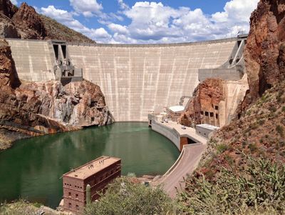
Theodore Roosevelt Dam, Hydroelectric dam on Salt River in Gila County and Maricopa County, United States.

Description

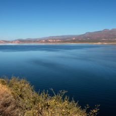
Theodore Roosevelt Dam is a concrete structure spanning the Salt River that creates a large water reservoir serving multiple functions. The construction manages power generation, water supply, and flood protection for central Arizona.

History

Construction took place between 1905 and 1911 as one of the first major federal projects under the 1902 Newlands Reclamation Act. The project demonstrated that the federal government could support large-scale infrastructure in western states.

Culture

The dam shows how early irrigation projects transformed land use across Arizona's desert and enabled farming communities to establish themselves. Visitors can observe how this structure shaped the relationship between people and water in this arid region.

Practical

Visitors can explore the dam from designated areas that offer viewpoints and information displays about its operation. The best time to visit is during cooler months, as desert temperatures become very high in summer.

Did you know?

The structure underwent major renovation from 1989 to 1996, with its height increased by 24 meters. This modernization significantly expanded storage capacity and showed how older infrastructure can be adapted for current needs.

Location
Location
Location
Elevation above the sea
655.6 m
Made from material
concrete
GPS coordinates
33.67150,-111.16150
Latest update
December 7, 2025 10:07

AroundUs brings together thousands of curated places, local tips, and hidden gems, enriched daily by 60,000 contributors worldwide. Discover all places nearby (Gila County).

Natural areas and historic sites in Arizona

Arizona contains geological formations spanning millions of years alongside evidence of Spanish colonial settlement and prehistoric cultures. The landscape includes sandstone canyons such as Antelope Canyon X and Canyon de Chelly National Monument, extensive desert areas with saguaro and organ pipe...

« Theodore Roosevelt Dam - Hydroelectric dam on Salt River in Gila County and Maricopa County, United States » is provided by Around Us (aroundus.com). Images and texts are derived from Wikimedia project under a Creative Commons license. You are allowed to copy, distribute, and modify copies of this page, under the conditions set by the license, as long as this note is clearly visible.

Discover hidden gems everywhere you go!

From secret cafés to breathtaking viewpoints, skip the crowded tourist spots and find places that match your style. Our app makes it easy with voice search, smart filtering, route optimization, and insider tips from travelers worldwide. Download now for the complete mobile experience.

Around Us App Screenshot

A unique approach to discovering new places

Le Figaro

All the places worth exploring

France Info

A tailor-made excursion in just a few clicks

20 Minutes

Around Us
Travel Guide & Maps
Download

Send to your phone

QR Code
1

Open the camera app on your mobile.

2

Point at the QR code with your camera. A notification will appear.

3

Tap the notification to open the link.