Enable Location

We need your location to show you interesting places around you

Discover nearby places

Find interesting locations and hidden gems around you

Precise directions

Get accurate directions and distances to places

Your location is never shared with other users. It's only used when you tap the location button.

Log in to your account

Start exploring — it's free

Trusted by 63,463 travelers worldwide

Continue with Google
Continue with Apple
or

We will send you a code to connect

By continuing, you accept our Terms and Conditions and our Privacy Policy

Check your inbox

We've sent a pincode in your inbox. Please enter the code below.

Reavis Falls
Discussion Reviews Photo
1.1k Popularity

Reavis Falls, Seasonal waterfall in Arizona

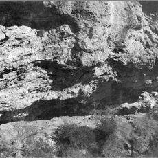
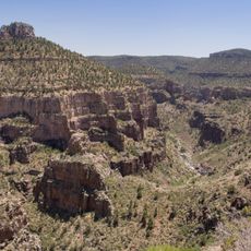
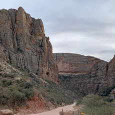
Reavis Falls is a waterfall in the Superstition Mountains in Arizona that drops over 190 feet into a rocky pool below. The cascade is surrounded by steep canyon walls, with ferns and moss framing the cliff face where water pours down.

The waterfall was named after Reavis Ranch, a settlement that existed in this remote mountain region. The area was inhabited by the Sinagua, an ancient culture whose presence is marked by pottery fragments and ruins found along the trail.

The hike starts at Reavis Ranch Trailhead and covers roughly 13 miles round trip with a steep, rocky descent into the canyon. Bring plenty of water, sturdy boots, and a map or GPS device, as the route becomes faint in places and navigation can be challenging on loose terrain.

The waterfall only flows after heavy rain or rare snowfall and can disappear entirely during dry periods, making each visit dependent on recent weather conditions. This variability means that seeing it at full strength is a memorable event that few visitors experience.

The community of curious travelers

AroundUs brings together thousands of curated places, local tips, and hidden gems, enriched daily by 60,000 contributors worldwide.

Start exploring
Location
GPS coordinates
33.53285,-111.16708
Latest update
February 9, 2026 07:40
Around this place
Theodore Roosevelt Lake
United States of America

Theodore Roosevelt Lake

15.5 km
Canyon Lake
United States of America

Canyon Lake

25.1 km
Lost Dutchman State Park
United States of America

Lost Dutchman State Park

30 km
Four Peaks
United States of America

Four Peaks

22.4 km
Saguaro Lake
United States of America

Saguaro Lake

33.5 km
Weaver's Needle
United States of America

Weaver's Needle

21.9 km
Skeleton Cave
United States of America

Skeleton Cave

19.5 km
Salt River Canyon Wilderness
United States of America

Salt River Canyon Wilderness

35.3 km
Boyce Thompson Arboretum
United States of America

Boyce Thompson Arboretum

28.3 km
Sears-Kay Ruin
United States of America

Sears-Kay Ruin

36.3 km
United States of America

Picketpost Mountain

30.8 km
Stewart Mountain Dam
United States of America

Stewart Mountain Dam

34.4 km
Mormon Flat Dam
United States of America

Mormon Flat Dam

25.6 km
Roosevelt Lake Bridge
United States of America

Roosevelt Lake Bridge

15.7 km
Gila County Courthouse
United States of America

Gila County Courthouse

38.5 km
United States of America

Peralta Canyon

24.7 km
Our Lady of the Blessed Sacrament Church
United States of America

Our Lady of the Blessed Sacrament Church

31.1 km
Gold Canyon Golf Resort
United States of America

Gold Canyon Golf Resort

31.7 km
Miami Community Church
United States of America

Miami Community Church

31.5 km
Tonto National Monument Visitor Center
United States of America

Tonto National Monument Visitor Center

13.5 km
Bullion Plaza Cultural Center and Museum
United States of America

Bullion Plaza Cultural Center and Museum

30.9 km
Goldfield Ghost Town
United States of America

Goldfield Ghost Town

30.9 km
Gila County Historical Museum
United States of America

Gila County Historical Museum

37.1 km
Apache Trail
United States of America

Apache Trail

37.5 km
Boulder Creek Bridge
United States of America

Boulder Creek Bridge

23.8 km
Pinto Creek Bridge
United States of America

Pinto Creek Bridge

27.3 km
Mormon Flat Bridge
United States of America

Mormon Flat Bridge

25.6 km
Queen Creek Bridge
United States of America

Queen Creek Bridge

31.2 km
Show the full map
Reviews
Share your experience

No review yet

Discussions
Start a discussion...

No discussion yet

« Reavis Falls - Seasonal waterfall in Arizona » is provided by Around Us (aroundus.com). Images and texts are derived from Wikimedia project under a Creative Commons license. You are allowed to copy, distribute, and modify copies of this page, under the conditions set by the license, as long as this note is clearly visible.

Discover hidden gems everywhere you go!

From secret cafés to breathtaking viewpoints, skip the crowded tourist spots and find places that match your style. Our app makes it easy with voice search, smart filtering, route optimization, and insider tips from travelers worldwide. Download now for the complete mobile experience.

Around Us App Screenshot

A unique approach to discovering new places

Le Figaro

All the places worth exploring

France Info

A tailor-made excursion in just a few clicks

20 Minutes

Around Us
Travel Guide & Maps
Download

Send to your phone

QR Code
1

Open the camera app on your mobile.

2

Point at the QR code with your camera. A notification will appear.

3

Tap the notification to open the link.